ℹ️ Skipped - page is already crawled
| Filter | Status | Condition | Details |
|---|---|---|---|
| HTTP status | PASS | download_http_code = 200 | HTTP 200 |
| Age cutoff | PASS | download_stamp > now() - 6 MONTH | 0.5 months ago |
| History drop | PASS | isNull(history_drop_reason) | No drop reason |
| Spam/ban | PASS | fh_dont_index != 1 AND ml_spam_score = 0 | ml_spam_score=0 |
| Canonical | PASS | meta_canonical IS NULL OR = '' OR = src_unparsed | Not set |
| Property | Value |
|---|---|
| URL | https://www.weather.gov/ffc/2017_irma |
| Last Crawled | 2026-04-01 07:30:25 (13 days ago) |
| First Indexed | 2020-10-29 15:27:47 (5 years ago) |
| HTTP Status Code | 200 |
| Meta Title | Irma Causes Widespread Damage in Georgia (9/11/17) |
| Meta Description | null |
| Meta Canonical | null |
| Boilerpipe Text | Irma Causes Widespread Damage in Georgia:
September 11, 2017
[
Overview
]
[
Damaging Wind
]
[
Wind Damage Photos
]
[
Heavy Rainfall
]
[
Why No Tornadoes?
]
Overview:
Major Hurricane Irma made landfall in southwest Florida on September 10, 2017. Irma moved northward through the day on September 10th, gradually losing intensity but continuing to bring widespread wind damage and heavy rainfall along its track. By the morning of Monday, September 11th, then-Tropical Storm Irma moved into Georgia with a very large wind field containing at least tropical storm force wind gusts (39+mph). These high winds lasted several hours across most of the state, which resulted in many thousands of downed trees and caused
1.5 million customers
in Georgia to lose power. Given the extensive damage, power was not restored to many areas for several days. With generally dry conditions prior to Irma's arrival, flooding issues in this area were relatively minor, though portions of southern and coastal Georgia outside of the NWS Atlanta/Peachtree City forecast area experienced more significant flooding as well as coastal storm surge.
Damaging Winds:
Widespread sustained winds of 30-45 mph with gusts in the 50-65 mph range downed numerous trees and power lines across the area. Many trees fell onto homes and businesses, causing additional damage. Unfortunately, at least two people were killed in the north Georgia due to falling trees with several others sustaining injuries. Below are some of the notable wind reports across the area during Tropical Storm Irma.
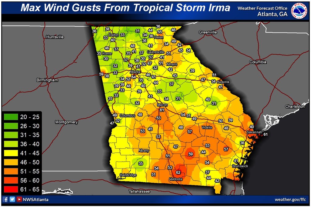
This map displays peak recorded wind gusts across Georgia during Irma.
(Click the map to enlarge it.)
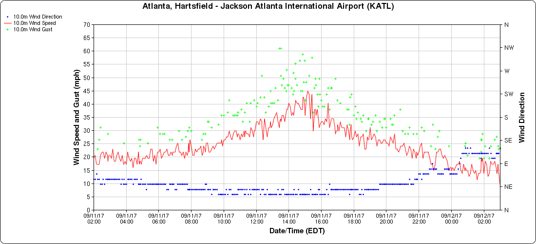
This graph shows wind direction and wind speed/gusts in miles per hour at Hartsfield-Jackson Airport in Atlanta.
(Courtesy MesoWest, University of Utah)
Note the frequent wind gusts between 50 and 65 mph.
Click the graph to enlarge it.
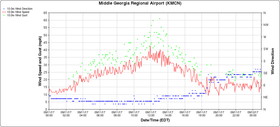
This graph shows wind direction and wind speed/gusts in miles per hour at Middle Georgia Regional Airport in Macon.
(Courtesy MesoWest, University of Utah)
Note the frequent wind gusts between 50 and 65 mph.
Click the graph to enlarge it.
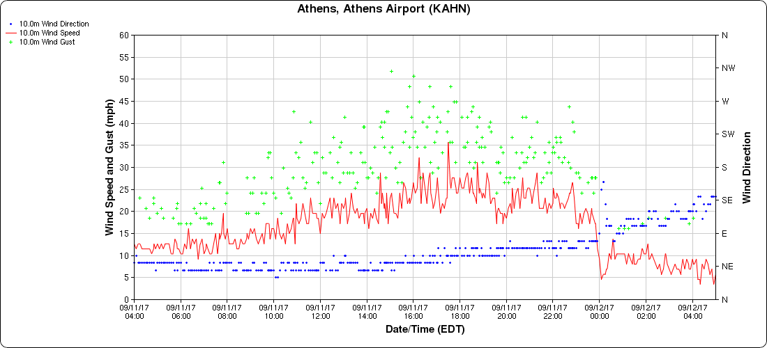
This graph shows wind direction and wind speed/gusts in miles per hour at the Athens Airport.
(Courtesy MesoWest, University of Utah)
Note the high wind gusts over 50 mph.
Click the graph to enlarge it.
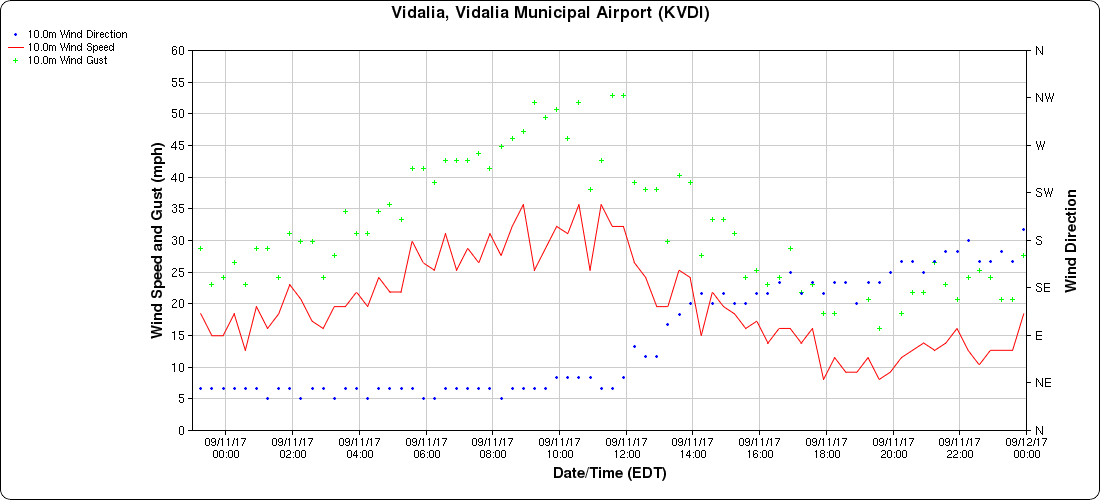
This graph shows wind direction and wind speed/gusts in miles per hour at the Vidalia airport.
(Courtesy MesoWest, University of Utah)
Note the high wind gusts over 50 mph.
Click the graph to enlarge it.
Wind Damage Photos:
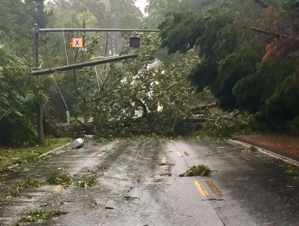
One large tree pulled down power lines as it fell across Memorial Drive in Atlanta, while another large tree on the right side of the roadway was also blown down.
This utility pole was pulled down on Memorial Drive in Atlanta.
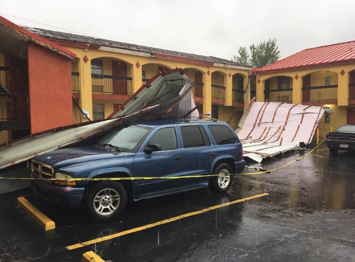
Part of the roof was removed from this motel in College Park. (Courtesy WSB-TV)
This large tree fell onto a home in McDonough. (Courtesy WSB-TV)
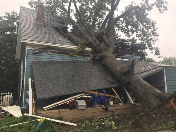
This huge tree fell onto a home in Commerce. (Courtesy WSB-TV)
Heavy Rainfall:
The heaviest rainfall totals were confined to far southeast Georgia, outside of the local forecast and warning area. In our local region, the highest rainfall totals were around 5 inches. Since the conditions immediately leading up to the passage of Irma were mostly dry, primarily minor flooding issues were experienced.
This map displays rainfall accumulation from 8 AM 9/10/17 - 8 AM 9/12/17.
(Click the map to enlarge it.)
Why Weren't There Any Tornadoes?:
Despite the fact that much of the area was on the side of Irma typically favorable for tornadoes, no tornadoes were recorded across the state during Irma's passage. The primary reason for this lack of tornadoes was the fact that an unseasonably cool and stable air mass was in place across the area. In fact, high temperatures were only in the 60s that day, which set record cool high temperatures for September 11th for many locations. These cool temperatures eliminated any instability that would have supported tornado-producing tropical convection associated with Irma.
|
| Markdown | [](https://www.weather.gov/) [](http://www.commerce.gov/)
- [HOME](https://www.weather.gov/ffc/2017_irma)
- [FORECAST](https://www.weather.gov/forecastmaps/)
- [Local](https://www.weather.gov/)
- [Graphical](https://digital.weather.gov/)
- [Aviation](https://aviationweather.gov/)
- [Marine](https://www.weather.gov/marine/)
- [Rivers and Lakes](https://water.noaa.gov/)
- [Hurricanes](https://www.nhc.noaa.gov/)
- [Severe Weather](https://www.spc.noaa.gov/)
- [Fire Weather](https://www.weather.gov/fire/)
- [Sunrise/Sunset](https://gml.noaa.gov/grad/solcalc/)
- [Long Range Forecasts](https://www.cpc.ncep.noaa.gov/)
- [Climate Prediction](https://www.cpc.ncep.noaa.gov/)
- [Space Weather](https://www.swpc.noaa.gov/)
- [PAST WEATHER](https://www.weather.gov/wrh/climate)
- [Past Weather](https://www.weather.gov/wrh/climate)
- [Astronomical Data](https://gml.noaa.gov/grad/solcalc/)
- [Certified Weather Data](https://www.climate.gov/maps-data/dataset/past-weather-zip-code-data-table)
- [SAFETY](https://www.weather.gov/safety/)
- [INFORMATION](https://www.weather.gov/informationcenter)
- [Wireless Emergency Alerts](https://www.weather.gov/wrn/wea)
- [Brochures](https://www.weather.gov/owlie/publication_brochures)
- [Weather-Ready Nation](https://www.weather.gov/wrn/)
- [Cooperative Observers](https://www.weather.gov/coop/)
- [Daily Briefing](https://www.weather.gov/briefing/)
- [Damage/Fatality/Injury Statistics](https://www.weather.gov/hazstat)
- [Forecast Models](http://mag.ncep.noaa.gov/)
- [GIS Data Portal](https://www.weather.gov/gis/)
- [NOAA Weather Radio](https://www.weather.gov/nwr)
- [Publications](https://www.weather.gov/publications/)
- [SKYWARN Storm Spotters](https://www.weather.gov/skywarn/)
- [StormReady](https://www.weather.gov/stormready)
- [TsunamiReady](https://www.weather.gov/tsunamiready/)
- [Service Change Notices](https://www.weather.gov/notification/)
- [EDUCATION](https://www.weather.gov/education/)
- [NEWS](https://www.weather.gov/news)
- [SEARCH](https://www.weather.gov/search/)
- [ABOUT](https://www.weather.gov/about/)
- [About NWS](https://www.weather.gov/about/)
- [Organization](https://www.weather.gov/organization)
- [For NWS Employees](https://sites.google.com/a/noaa.gov/nws-insider/)
- [National Centers](https://www.weather.gov/ncep/)
- [Careers](https://www.noaa.gov/nws-careers)
- [Contact Us](https://www.weather.gov/contact)
- [Glossary](https://forecast.weather.gov/glossary.php)
- [Social Media](https://www.weather.gov/socialmedia)
- [NWS Transformation](https://www.noaa.gov/NWStransformation)
News Headlines
- [**Check out our StoryMap on tornadoes in our area so far in 2026\!**](http://storymaps.arcgis.com/stories/a8f59e9db66c4fe79dd86a06dcee2009)
- [**Previous Headlines and Features appearing on our Front Page**](https://www.weather.gov/ffc/prev26)
- [**2026 Flood Safety Preparedness Week**](https://www.weather.gov/ffc/flood_preparedness)
LOADING...
Atlanta/Peachtree City, GA
Weather Forecast Office
# Irma Causes Widespread Damage in Georgia (9/11/17)
[Weather.gov](https://www.weather.gov/) \> [Atlanta/Peachtree City, GA](https://www.weather.gov/ffc) \> Irma Causes Widespread Damage in Georgia (9/11/17)
- [Current Hazards](https://forecast.weather.gov/product.php?site=NWS&issuedby=FFC&product=HWO)
- [Submit a Storm Report](https://www.weather.gov/ffc/strmsubm1)
- [Local Warnings](https://www.weather.gov/ffc/warnings)
- [Outlooks](http://www.weather.gov/crh/outlooks?sid=ffc)
- [Nationwide](https://www.weather.gov/ffc/ntnlhaz)
- [Outlooks](https://www.weather.gov/ffc/hwo)
- [Local Storm Reports](http://forecast.weather.gov/product.php?site=NWS&issuedby=FFC&product=LSR)
- [Georgia Road Conditions](http://www.511ga.org/)
- [Current Conditions](https://www.weather.gov/)
- [Satellite](https://www.weather.gov/ffc/wxdatsat)
- [Observed Precipitation](http://water.noaa.gov/precip/)
- [Surface Observations](https://www.weather.gov/wrh/hazards?obs=true&boundaries=true&wfo=ffc)
- [Satellite Images](https://www.weather.gov/ffc/wxdatsat)
- [Rivers/Lakes](https://water.noaa.gov/wfo/FFC)
- [Maps](https://www.weather.gov/ffc/mapslast)
- [Radar](https://radar.weather.gov/)
- [Local KFFC Standard Radar (low bandwith)](https://radar.weather.gov/station/KFFC/standard)
- [Local KFFC Enhanced Radar](https://radar.weather.gov/?settings=v1_eyJhZ2VuZGEiOnsiaWQiOiJsb2NhbCIsImNlbnRlciI6Wy04NC41NjYsMzMuMzYzXSwibG9jYXRpb24iOm51bGwsInpvb20iOjcuOTc2OTA2Mjc2NDQ0NTk2LCJmaWx0ZXIiOiJXU1ItODhEIiwibGF5ZXIiOiJzcl9icmVmIiwic3RhdGlvbiI6IktGRkMifSwiYW5pbWF0aW5nIjpmYWxzZSwiYmFzZSI6InN0YW5kYXJkIiwiYXJ0Y2MiOmZhbHNlLCJjb3VudHkiOmZhbHNlLCJjd2EiOmZhbHNlLCJyZmMiOmZhbHNlLCJzdGF0ZSI6ZmFsc2UsIm1lbnUiOnRydWUsInNob3J0RnVzZWRPbmx5Ijp0cnVlLCJvcGFjaXR5Ijp7ImFsZXJ0cyI6MC44LCJsb2NhbCI6MC42LCJsb2NhbFN0YXRpb25zIjowLjgsIm5hdGlvbmFsIjowLjZ9fQ%3D%3D#/)
- [Local KJGX Standard Radar (low bandwith)](https://radar.weather.gov/station/KJGX/standard)
- [Local KJGX Enhanced Radar](https://radar.weather.gov/?settings=v1_eyJhZ2VuZGEiOnsiaWQiOiJsb2NhbCIsImNlbnRlciI6Wy04My4zNTEsMzIuNjc1XSwibG9jYXRpb24iOm51bGwsInpvb20iOjcuOTc2OTA2Mjc2NDQ0NTk2LCJmaWx0ZXIiOiJXU1ItODhEIiwibGF5ZXIiOiJzcl9icmVmIiwic3RhdGlvbiI6IktKR1gifSwiYW5pbWF0aW5nIjpmYWxzZSwiYmFzZSI6InN0YW5kYXJkIiwiYXJ0Y2MiOmZhbHNlLCJjb3VudHkiOmZhbHNlLCJjd2EiOmZhbHNlLCJyZmMiOmZhbHNlLCJzdGF0ZSI6ZmFsc2UsIm1lbnUiOnRydWUsInNob3J0RnVzZWRPbmx5Ijp0cnVlLCJvcGFjaXR5Ijp7ImFsZXJ0cyI6MC44LCJsb2NhbCI6MC42LCJsb2NhbFN0YXRpb25zIjowLjgsIm5hdGlvbmFsIjowLjZ9fQ%3D%3D#/)
- [Regional Standard Radar (low bandwith)](https://radar.weather.gov/region/southeast/standard)
- [Forecasts](https://www.weather.gov/ffc/2017_irma)
- [Forecaster's Discussion](http://forecast.weather.gov/product.php?site=NWS&issuedby=FFC&product=AFD&format=CI&version=1&glossary=1)
- [Probabilistic Precipitation](https://www.weather.gov/crh/pqpf?sid=ffc)
- [Fire](https://www.weather.gov/ffc/fire)
- [Hourly View](http://forecast.weather.gov/gridpoint.php?site=ffc&TypeDefault=graphical)
- [Local](https://www.weather.gov/ffc/fcsts)
- [Graphical](http://graphical.weather.gov/sectors/conus.php)
- [Tropical Weather](https://www.weather.gov/srh/tropical?office=ffc)
- [Aviation Weather](https://www.weather.gov/ffc/avlast)
- [Winter Weather](https://www.weather.gov/ffc/winter)
- [Computer Models](https://www.weather.gov/ffc/models)
- [Decision Support](https://www.weather.gov/ffc/dss)
- [Recreational Forecast](https://www.weather.gov/ffc/recfcst)
- [Severe](https://www.weather.gov/ffc/severe)
- [Cold](https://www.weather.gov/ffc/cold)
- [Heat](https://www.weather.gov/ffc/heat)
- [Rivers and Lakes](https://water.noaa.gov/wfo/ffc)
- [\*New\* National Water Prediction Service (NWPS)](https://water.noaa.gov/)
- [\*New\* NWPS - Local View](https://water.noaa.gov/wfo/FFC)
- [Climate and Past Weather](https://www.weather.gov/wrh/Climate?wfo=ffc)
- [Climate Prediction](http://www.cpc.ncep.noaa.gov/)
- [Drought](http://www.drought.gov/drought/)
- [National](http://www.weather.gov/climate/)
- [Rainfall](https://www.weather.gov/ffc/rainresrc)
- [Yearly Climate Graphs](https://www.weather.gov/ffc/climateplot)
- [Climate FAQs](https://www.weather.gov/ffc/climate_faq)
- [More...](https://www.weather.gov/climate/local_data.php?wfo=ffc)
- [Tropical Cyclone Reports](https://www.weather.gov/ffc/TropicalEventSummary)
- [Local Drought Info](https://www.weather.gov/ffc/drought)
- [Local Programs](https://www.weather.gov/ffc/)
- [Deaf and Hard of Hearing](https://www.weather.gov/ffc/deafandhardofhearing)
- [NOAA Weather Radio](https://www.weather.gov/ffc/radio)
- [SKYWARN](https://www.weather.gov/ffc/skywarn)
- [StormReady](https://www.weather.gov/ffc/sready)
- [User's Guide](https://www.weather.gov/ffc/uguide)
- [Education & Outreach](https://www.weather.gov/ffc/outreach)
- [Archived Info](https://www.weather.gov/ffc/archives/)
- [Past Weather Events](https://www.weather.gov/ffc/past_events)
- [Research](https://www.weather.gov/ffc/research)
- [FAQs](https://www.weather.gov/ffc/faq)
- [Our Office](https://www.weather.gov/ffc/officelst)
- [Contact Us](https://www.weather.gov/ffc/contact)
**Irma Causes Widespread Damage in Georgia:**
**September 11, 2017**
\[[Overview](https://www.weather.gov/ffc/2017_irma#overview)\]
\[[Damaging Wind](https://www.weather.gov/ffc/2017_irma#damagingwind)\]
\[[Wind Damage Photos](https://www.weather.gov/ffc/2017_irma#winddamagephoto)\]
\[[Heavy Rainfall](https://www.weather.gov/ffc/2017_irma#heavyrainfall)\]
\[[Why No Tornadoes?](https://www.weather.gov/ffc/2017_irma#notornadoes)\]
**Overview:**
Major Hurricane Irma made landfall in southwest Florida on September 10, 2017. Irma moved northward through the day on September 10th, gradually losing intensity but continuing to bring widespread wind damage and heavy rainfall along its track. By the morning of Monday, September 11th, then-Tropical Storm Irma moved into Georgia with a very large wind field containing at least tropical storm force wind gusts (39+mph). These high winds lasted several hours across most of the state, which resulted in many thousands of downed trees and caused **1\.5 million customers** in Georgia to lose power. Given the extensive damage, power was not restored to many areas for several days. With generally dry conditions prior to Irma's arrival, flooding issues in this area were relatively minor, though portions of southern and coastal Georgia outside of the NWS Atlanta/Peachtree City forecast area experienced more significant flooding as well as coastal storm surge.
**Damaging Winds:**
Widespread sustained winds of 30-45 mph with gusts in the 50-65 mph range downed numerous trees and power lines across the area. Many trees fell onto homes and businesses, causing additional damage. Unfortunately, at least two people were killed in the north Georgia due to falling trees with several others sustaining injuries. Below are some of the notable wind reports across the area during Tropical Storm Irma.
| |
|---|
| [](https://www.weather.gov/images/ffc/events/2017_Irma/Irma_Wind_Gusts.jpg) |
| **This map displays peak recorded wind gusts across Georgia during Irma.** (Click the map to enlarge it.) |
| |
|---|
| [](https://www.weather.gov/images/ffc/events/2017_Irma/ATL_irma_wind.png) |
| **This graph shows wind direction and wind speed/gusts in miles per hour at Hartsfield-Jackson Airport in Atlanta.** (Courtesy MesoWest, University of Utah) Note the frequent wind gusts between 50 and 65 mph. Click the graph to enlarge it. |
| |
|---|
| [](https://www.weather.gov/images/ffc/events/2017_Irma/MCN_Irma_wind.png) |
| **This graph shows wind direction and wind speed/gusts in miles per hour at Middle Georgia Regional Airport in Macon.** (Courtesy MesoWest, University of Utah) Note the frequent wind gusts between 50 and 65 mph. Click the graph to enlarge it. |
| |
|---|
| [](https://www.weather.gov/images/ffc/events/2017_Irma/AHN_irma_wind.png) |
| **This graph shows wind direction and wind speed/gusts in miles per hour at the Athens Airport.** (Courtesy MesoWest, University of Utah) Note the high wind gusts over 50 mph. Click the graph to enlarge it. |
| |
|---|
| [](https://www.weather.gov/images/ffc/events/2017_Irma/Vidalia_irma_wind.png) |
| **This graph shows wind direction and wind speed/gusts in miles per hour at the Vidalia airport.** (Courtesy MesoWest, University of Utah) Note the high wind gusts over 50 mph. Click the graph to enlarge it. |
***Wind Damage Photos:***
| | |
|---|---|
| [](https://www.weather.gov/images/ffc/events/2017_Irma/IMG_9774.JPG) | [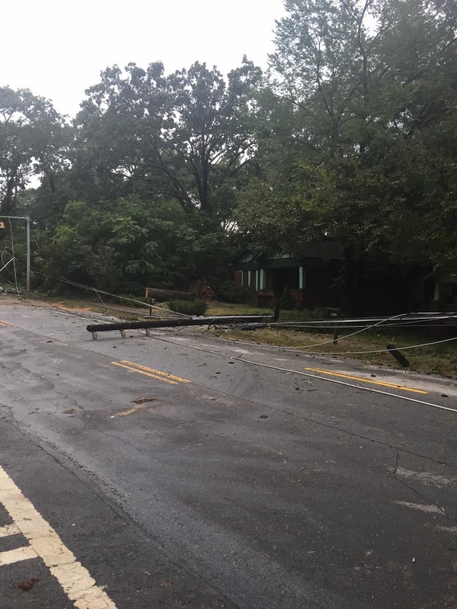](https://www.weather.gov/images/ffc/events/2017_Irma/IMG_9741.JPG) |
| One large tree pulled down power lines as it fell across Memorial Drive in Atlanta, while another large tree on the right side of the roadway was also blown down. | This utility pole was pulled down on Memorial Drive in Atlanta. |
| | |
|---|---|
| [](https://www.weather.gov/images/ffc/events/2017_Irma/College_Park_motel_irma.jpg) | [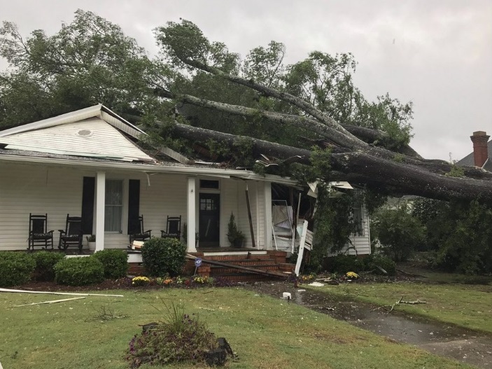](https://www.weather.gov/images/ffc/events/2017_Irma/Tree_on_house_McDonough.jpg) |
| Part of the roof was removed from this motel in College Park. (Courtesy WSB-TV) | This large tree fell onto a home in McDonough. (Courtesy WSB-TV) |
| |
|---|
| [](https://www.weather.gov/images/ffc/events/2017_Irma/tree_on_house_commerce.jpg) |
| This huge tree fell onto a home in Commerce. (Courtesy WSB-TV) |
**Heavy Rainfall:**
The heaviest rainfall totals were confined to far southeast Georgia, outside of the local forecast and warning area. In our local region, the highest rainfall totals were around 5 inches. Since the conditions immediately leading up to the passage of Irma were mostly dry, primarily minor flooding issues were experienced.
| |
|---|
| [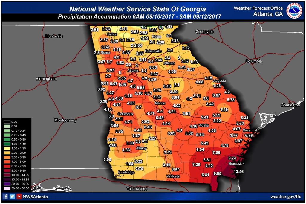](https://www.weather.gov/images/ffc/events/2017_Irma/irma_rainfall_totals.jpg) |
| **This map displays rainfall accumulation from 8 AM 9/10/17 - 8 AM 9/12/17.** (Click the map to enlarge it.) |
**Why Weren't There Any Tornadoes?:**
Despite the fact that much of the area was on the side of Irma typically favorable for tornadoes, no tornadoes were recorded across the state during Irma's passage. The primary reason for this lack of tornadoes was the fact that an unseasonably cool and stable air mass was in place across the area. In fact, high temperatures were only in the 60s that day, which set record cool high temperatures for September 11th for many locations. These cool temperatures eliminated any instability that would have supported tornado-producing tropical convection associated with Irma.
[ Follow us on X](https://twitter.com/NWSAtlanta)
[ Follow us on Facebook](https://www.facebook.com/NWSAtlanta)
[ Follow us on YouTube](https://www.youtube.com/NWSPeachtreeCity)
[ FFC RSS Feed](https://www.weather.gov/rss_page.php?site_name=ffc)
[Current Hazards](https://www.weather.gov/ffc/2017_irma)
[Outlooks](https://www.weather.gov/ffc/hwo)
[Georgia Road Conditions](http://www.511ga.org/)
[Nationwide](https://www.weather.gov/ffc/ntnlhaz)
[Local Storm Reports](http://forecast.weather.gov/product.php?site=NWS&issuedby=FFC&product=LSR)
[Local](https://www.weather.gov/ffc/warnings)
[Submit Storm Report](https://www.weather.gov/ffc/strmsubm1)
[Forecasts](https://www.weather.gov/ffc/2017_irma)
[Forecast Discussion](http://forecast.weather.gov/product.php?site=NWS&issuedby=FFC&product=AFD)
[Incident Support](https://www.weather.gov/ffc/dss)
[Tropical Weather](https://www.weather.gov/srh/tropical?office=ffc)
[Local](https://www.weather.gov/ffc/fcsts)
[Computer Models](https://www.weather.gov/ffc/models)
[Graphical](http://graphical.weather.gov/sectors/ffc.php)
[Aviation Weather](https://www.weather.gov/ffc/avlast)
[Activity Planner](http://forecast.weather.gov/wxplanner.php?site=ffc)
[Recreational Forecast](https://www.weather.gov/ffc/recfcst)
[Fire Weather](https://www.weather.gov/ffc/firewx)
[Current Weather](https://www.weather.gov/ffc/2017_irma)
[Rivers/Lakes](http://water.weather.gov/ahps2/index.php?wfo=ffc)
[Satellite Images](https://www.weather.gov/ffc/wxdatsat)
[Observations](https://www.weather.gov/ffc/observations)
[Maps](https://www.weather.gov/ffc/mapslast)
[Radar Imagery](https://www.weather.gov/ffc/2017_irma)
[Regional Loop](https://radar.weather.gov/region/southeast/standard)
[Nationwide](https://radar.weather.gov/region/conus/standard)
[Warner Robins](https://radar.weather.gov/station/KJGX/standard)
[Peachtree City](https://radar.weather.gov/station/KFFC/standard)
[Climate](https://www.weather.gov/ffc/2017_irma)
[Local](https://www.weather.gov/wrh/Climate?wfo=ffc)
[National](http://www.weather.gov/climate/)
[Rainfall](https://www.weather.gov/ffc/rainresrc)
[Yearly Climate Graphs](https://www.weather.gov/ffc/climateplot)
[Climate FAQs](https://www.weather.gov/ffc/climate_faq)
[Weather Safety](https://www.weather.gov/ffc/2017_irma)
[Weather Radio](https://www.weather.gov/ffc/radio)
[Get Prepared](https://www.weather.gov/ffc/prep)
[StormReady](https://www.weather.gov/ffc/sready)
[SKYWARN](https://www.weather.gov/ffc/skywarn)
[Additional Info](https://www.weather.gov/ffc/2017_irma)
[User's Guide](https://www.weather.gov/ffc/uguide)
[Archived Info](https://www.weather.gov/ffc/archives)
[Education and Outreach](https://www.weather.gov/ffc/outreach)
[About Us](https://www.weather.gov/ffc/2017_irma)
[Shareholder's Report](https://www.weather.gov/ffc/anreports)
[FAQs](https://www.weather.gov/ffc/faq)
[Our Office](https://www.weather.gov/ffc/officelst)
[Past Weather Events](https://www.weather.gov/ffc/past_events)
[Research](https://www.weather.gov/ffc/research)
[Contact us](https://www.weather.gov/ffc/contact)
[](http://www.usa.gov/)
[US Dept of Commerce](http://www.commerce.gov/)
[National Oceanic and Atmospheric Administration](http://www.noaa.gov/)
[National Weather Service](https://www.weather.gov/)
Atlanta/Peachtree City, GA
4 Falcon Drive
Peachtree City, GA 30269
770\.486.1133
[Comments? Questions? Please Contact Us.](mailto:sr-ffc.webmaster@noaa.gov)
[Disclaimer](https://www.weather.gov/disclaimer)
[Information Quality](http://www.cio.noaa.gov/services_programs/info_quality.html)
[Help](https://www.weather.gov/help)
[Glossary](https://www.weather.gov/glossary)
[Privacy Policy](https://www.weather.gov/privacy)
[Freedom of Information Act (FOIA)](https://www.noaa.gov/foia-freedom-of-information-act)
[About Us](https://www.weather.gov/about)
[Career Opportunities](https://www.weather.gov/careers) |
| Readable Markdown | **Irma Causes Widespread Damage in Georgia:**
**September 11, 2017**
\[[Overview](https://www.weather.gov/ffc/2017_irma#overview)\]
\[[Damaging Wind](https://www.weather.gov/ffc/2017_irma#damagingwind)\]
\[[Wind Damage Photos](https://www.weather.gov/ffc/2017_irma#winddamagephoto)\]
\[[Heavy Rainfall](https://www.weather.gov/ffc/2017_irma#heavyrainfall)\]
\[[Why No Tornadoes?](https://www.weather.gov/ffc/2017_irma#notornadoes)\]
**Overview:**
Major Hurricane Irma made landfall in southwest Florida on September 10, 2017. Irma moved northward through the day on September 10th, gradually losing intensity but continuing to bring widespread wind damage and heavy rainfall along its track. By the morning of Monday, September 11th, then-Tropical Storm Irma moved into Georgia with a very large wind field containing at least tropical storm force wind gusts (39+mph). These high winds lasted several hours across most of the state, which resulted in many thousands of downed trees and caused **1\.5 million customers** in Georgia to lose power. Given the extensive damage, power was not restored to many areas for several days. With generally dry conditions prior to Irma's arrival, flooding issues in this area were relatively minor, though portions of southern and coastal Georgia outside of the NWS Atlanta/Peachtree City forecast area experienced more significant flooding as well as coastal storm surge.
**Damaging Winds:**
Widespread sustained winds of 30-45 mph with gusts in the 50-65 mph range downed numerous trees and power lines across the area. Many trees fell onto homes and businesses, causing additional damage. Unfortunately, at least two people were killed in the north Georgia due to falling trees with several others sustaining injuries. Below are some of the notable wind reports across the area during Tropical Storm Irma.
| |
|---|
| [](https://www.weather.gov/images/ffc/events/2017_Irma/Irma_Wind_Gusts.jpg) |
| **This map displays peak recorded wind gusts across Georgia during Irma.** (Click the map to enlarge it.) |
| |
|---|
| [](https://www.weather.gov/images/ffc/events/2017_Irma/ATL_irma_wind.png) |
| **This graph shows wind direction and wind speed/gusts in miles per hour at Hartsfield-Jackson Airport in Atlanta.** (Courtesy MesoWest, University of Utah) Note the frequent wind gusts between 50 and 65 mph. Click the graph to enlarge it. |
| |
|---|
| [](https://www.weather.gov/images/ffc/events/2017_Irma/MCN_Irma_wind.png) |
| **This graph shows wind direction and wind speed/gusts in miles per hour at Middle Georgia Regional Airport in Macon.** (Courtesy MesoWest, University of Utah) Note the frequent wind gusts between 50 and 65 mph. Click the graph to enlarge it. |
| |
|---|
| [](https://www.weather.gov/images/ffc/events/2017_Irma/AHN_irma_wind.png) |
| **This graph shows wind direction and wind speed/gusts in miles per hour at the Athens Airport.** (Courtesy MesoWest, University of Utah) Note the high wind gusts over 50 mph. Click the graph to enlarge it. |
| |
|---|
| [](https://www.weather.gov/images/ffc/events/2017_Irma/Vidalia_irma_wind.png) |
| **This graph shows wind direction and wind speed/gusts in miles per hour at the Vidalia airport.** (Courtesy MesoWest, University of Utah) Note the high wind gusts over 50 mph. Click the graph to enlarge it. |
***Wind Damage Photos:***
| | |
|---|---|
| [](https://www.weather.gov/images/ffc/events/2017_Irma/IMG_9774.JPG) | [](https://www.weather.gov/images/ffc/events/2017_Irma/IMG_9741.JPG) |
| One large tree pulled down power lines as it fell across Memorial Drive in Atlanta, while another large tree on the right side of the roadway was also blown down. | This utility pole was pulled down on Memorial Drive in Atlanta. |
| | |
|---|---|
| [](https://www.weather.gov/images/ffc/events/2017_Irma/College_Park_motel_irma.jpg) | [](https://www.weather.gov/images/ffc/events/2017_Irma/Tree_on_house_McDonough.jpg) |
| Part of the roof was removed from this motel in College Park. (Courtesy WSB-TV) | This large tree fell onto a home in McDonough. (Courtesy WSB-TV) |
| |
|---|
| [](https://www.weather.gov/images/ffc/events/2017_Irma/tree_on_house_commerce.jpg) |
| This huge tree fell onto a home in Commerce. (Courtesy WSB-TV) |
**Heavy Rainfall:**
The heaviest rainfall totals were confined to far southeast Georgia, outside of the local forecast and warning area. In our local region, the highest rainfall totals were around 5 inches. Since the conditions immediately leading up to the passage of Irma were mostly dry, primarily minor flooding issues were experienced.
| |
|---|
| [](https://www.weather.gov/images/ffc/events/2017_Irma/irma_rainfall_totals.jpg) |
| **This map displays rainfall accumulation from 8 AM 9/10/17 - 8 AM 9/12/17.** (Click the map to enlarge it.) |
**Why Weren't There Any Tornadoes?:**
Despite the fact that much of the area was on the side of Irma typically favorable for tornadoes, no tornadoes were recorded across the state during Irma's passage. The primary reason for this lack of tornadoes was the fact that an unseasonably cool and stable air mass was in place across the area. In fact, high temperatures were only in the 60s that day, which set record cool high temperatures for September 11th for many locations. These cool temperatures eliminated any instability that would have supported tornado-producing tropical convection associated with Irma. |
| Shard | 181 (laksa) |
| Root Hash | 14582890608774637581 |
| Unparsed URL | gov,weather!www,/ffc/2017_irma s443 |