ℹ️ Skipped - page is already crawled
| Filter | Status | Condition | Details |
|---|---|---|---|
| HTTP status | PASS | download_http_code = 200 | HTTP 200 |
| Age cutoff | PASS | download_stamp > now() - 6 MONTH | 0.2 months ago |
| History drop | PASS | isNull(history_drop_reason) | No drop reason |
| Spam/ban | PASS | fh_dont_index != 1 AND ml_spam_score = 0 | ml_spam_score=0 |
| Canonical | PASS | meta_canonical IS NULL OR = '' OR = src_unparsed | Not set |
| Property | Value |
|---|---|
| URL | https://www.visit-vermont.com/northern/walking-hiking/ |
| Last Crawled | 2026-04-16 04:40:39 (5 days ago) |
| First Indexed | 2018-06-25 18:03:21 (7 years ago) |
| HTTP Status Code | 200 |
| Meta Title | Walking and Hiking - Outdoor Activities in Northern Vermont |
| Meta Description | Visit Northern Vermont on your family vacation for walking and hiking trails in the area’s mountains, parks and forests in Lake Elmore, Groton and other regions. |
| Meta Canonical | null |
| Boilerpipe Text | Intervale Center Trails
180 Intervale Road
Burlington, VT, 05401
Phone: 802-660-0440
This farm- and food-loving organization declares a mission of strengthening community food systems. Among its many offerings is to welcome people to the outdoors. The Intervale is open to the public every day. Recreational trails wind along the Winooski River to the
Ethan Allen Homestead
. They are used for biking, walking, and jogging, In winter, three miles of cross-country ski trails are groomed for classic and skate skiers. Bicyclists: Intervale roads are part of
Cycle the City
, a self-guided loop that winds through Burlington and the Ethan Allen Homestead, up to the University of Vermont and downtown Burlington. -
Trail Map (PDF)
Parking:
Visitors to the Intervale Center may park at two public parking lots off of Intervale Road, or in the lot across the street from Gardener’s Supply, at 128 Intervale Road.
Gillespie/Copp-Welch Trails
Off Gilman or Lewis Creek Road
Hinesburg, VT, 05461
Phone:
Easy-to moderate level foot trails on a 3-mile loop a few miles southeast of Hinesburg Village center. Trails pass through forest and fields. Good for hiking, cross-country skiing, snowshoeing, and horseback riding. Part of the
Hinesburg Area Recreational Trails system
, managed by the Hinesburg Town Trails Committee.
The Trail
: Parked dirt, grass and meadow. Loop trail. Three miles.
Access
: via Gilman Road or Lewis Creek Road.
Elmore State Park’s Fire Tower and Balanced Rock Trails
856 VT Route 12
Lake Elmore, VT, 05657
Phone: 802-888-2982
Mix of easy and moderate walks 0.5 to 1.25 miles; some good for kids
There is a variety of trails to explore, from easy to moderate to difficult. Mountain Brook Nature Trail is approximately 0.5 mile in length (about 30 minutes for a leisurely stroll). Printed brochure describes plant and wild life. Beaver Trail is 0.50 mile and easy. Passes through woodlands and wetlands.
Two trails in the park are rated moderate to difficult, and not for children. Elmore Mountain Trail (also called Fire Tower Trail) is 1.25 miles, ending at a fire tower with spectacular views of the Presidential Range in New Hampshire to Jay Peak and Mount Mansfield in Vermont. The Balancing Rock Trail is 0.5 miles through woodlands and along ledges, leading to a cool boulder balancing on its tip. -
Mountain Brook Nature Trail Guide (PDF)
Niquette Bay State Park Trails
274 Raymond Road
Colchester, VT, 05446
Phone: 802-893-5210
Five easy or moderate walks; 0.25 to 1.50 miles; some good for kids
This state park is perched on the shore of Malletts Bay. It is an easy drive along Routes 89 or 7 to Burlington and Shelburne, to the south, or along Route 2, out to the beautiful Lake Champlain Islands, for day trips. Both places have many great attractions for adults and kids.
The park’s trails offer three loops and a variety of hiking combinations ranging from 0.6 miles to 3.5 miles. Most are rated moderate difficulty; the Burns and Allen Trails are rated easy. Views of the lake, ridges, and distant mountains. Parking is next to the park office at the entrance to the property. Pets are welcome; proof of rabies vaccination is required. The Burns, Muhley, and Island View trails are designated off-leash areas. -
Interactive Map (PDF)
Smuggler's Notch State Park Trails
6443 Mountain Road
Stowe, VT, 05672
Phone: 802-253-4014
Moderate to difficult trails in high mountains; not for children
Smugglers' Notch is a narrow pass through the mountain with 1,000 foot cliffs. Today, it is the home of peregrine falcons and it is heavily used by hikers and ice climbers. The entrance road is passable by vehicles only in summer. A well-loved trail up the mountain is the Long Trail, which can be reached from the Notch. The Long Trail passes Elephant’s Head and Sterling Pond, a beautiful and serene mountain lake. The Hell Brook Trail is a shorter but much steeper route to the summit of Mount Mansfield. -
Trail Map (PDF)
Knight Point State Park
44 Knight Point Road
North Hero, VT, 05474
Phone: 802-372-8389
Easy walk; one mile; good for kids
This easy, one-mile trail skirts one point of Knight Point State Park, which is located at the southern end of North Hero Island, one of the Lake Champlain Islands. The trail passes through woodland and along the shore, offering views of the lake and lots of boat traffic. The Lake Champlain Islands are the closest image of Heaven you are likely to find anywhere. Twisty roads through rural areas and small towns offer beautiful views of the lake and distant mountain tops on all sides. -
Interactive Map (PDF)
Underhill State Park Trails
352 Mountain Road
Underhill, VT, 05490
Phone: 802-899-3022
Trails are moderate to difficult, to the summit of Mount Mansfield; not for kids; entrance road does not accommodate RVs, trailers, large buses
Underhill State Park is 2,000 feet above sea level on the slope of Mount Mansfield, the state’s tallest peak. From this park four hiking trails lead to the summit ridge of Mount Mansfield. The Sunset Ridge trail is the most popular.
Vermont’s Long Trail crosses the summit ridge and provides many hiking loops on both slopes of the mountain. The ridgeline is above tree line, and plants in this area are of the alpine tundra varieties. The ridge offers views of Lake Champlain and the mountains of New York. -
Interactive Trail Map (PDF)
Whales Tails Walking Path
30 Community Drive - Technology Park
Williston, VT, 05403
Phone:
This easy, 1.7-mile loop travels around the 13-foot-tall Whale Tails sculpture, a familiar sight off of I-89 south of Burlington. The granite sculpture, created by Jim Sardonis, was a finalist for a museum front in Anchorage, Alaska. The sculpture's title, "Reverence," is meant to evoke the fragility of the planet.It now occupies the property of Technology Park and is the centerpiece of a walking path. Nice walk for photographers; Vermont whales are rare and these two fellows are very popular. Photo Credit: Michael Weizenegger
Peninsula Nature Trail at Waterbury Center State Park
177 Reservoir Road
Waterbury Center, VT, 05677
Phone: 802-244-1226
Waterbury Center State Park lies on the Waterbury Reservoir, a quarter mile off VT Route 100. The park is open from Memorial Day to the second week of October. This walk is about one-half mile and easy. Good for kids. -
Nature Trail Map (PDF)
Mount Philo State Park
5425 Humphreys' Road
Charlotte, VT, 05445
Phone: 802-425-2390
Park on a mountain top has magnificent views; camping; hiking; pets allowed
This park atop Mount Philo has magnificent views. There are hiking trails from the mountain base to the summit.
The main trail enters the woods off the park road and proceeds uphill to House Rock. One-half mile up the main trail, an offshoot trail goes to the right to Devil’s Chair, a huge boulder. The summit ledges and picnic area are a short, steep climb. Use blue blazes. -
Trail Guide (PDF)
Stowe Recreational Path
Along Mountain Road (Route 108)
Stowe, VT
Phone: 802-253-2264
Total Length: 5.3 Miles
The Stowe Recreation Path is an easy walking trail that winds through the Village of Stowe and crosses the West Branch River. The 5.5-mile one-way path (not loop) is paved and easy to reach. It is open all year, for walking, running, cycling, Nordic skiing and snowshoeing. Stay out of the groomed ski tracks during the winter. Dogs allowed on leash.
Access Points:
Lintilhac Park behind the Stowe Community Church on Main Street; Chase Park across from Stony Brook Condominiums on Luce Hill Road; Thompson Park off Route 108 across from the Percy Farm Corn Maze; Topnotch access off Brook Road, just past Topnotch Resort on Route 108. |
| Markdown | 
- [Maps](https://www.visit-vermont.com/state/vtmap/)
- [Subscribe](https://mailchi.mp/visitnewengland/lwimsaeguj)
- [Blog](https://blog.visitnewengland.com/)
[](https://www.visitnewengland.com/all/)
- [State: VT](https://www.visit-vermont.com/northern/walking-hiking/)
[Connecticut](https://www.visitconnecticut.com/)
[State](https://www.visitconnecticut.com/state/) [Fairfield Southwest](https://www.visitconnecticut.com/fairfield_southwest/) [Hartford Central](https://www.visitconnecticut.com/hartford_central/) [Litchfield Northwest](https://www.visitconnecticut.com/litchfield_northwest/) [Mystic Eastern](https://www.visitconnecticut.com/mystic_eastern/) [New Haven South Central](https://www.visitconnecticut.com/newhaven_southcentral/)
[Maine](https://www.visit-maine.com/)
[State](https://www.visit-maine.com/state/) [Bar Harbor Acadia](https://www.visit-maine.com/acadiadowneast/) [Greater Portland](https://www.visit-maine.com/greaterportlandcascobay/) [Mid Coast](https://www.visit-maine.com/midcoast/) [Northern Maine](https://www.visit-maine.com/northern/) [South Coast](https://www.visit-maine.com/southcoast/) [Western Lakes Mountains](https://www.visit-maine.com/westernlakesmountains/)
[Massachusetts](https://www.visit-massachusetts.com/)
[State](https://www.visit-massachusetts.com/state/) [Cape Cod & The Islands](https://www.visit-massachusetts.com/capecod-marthasvineyard-nantucket/) [Central Mass.](https://www.visit-massachusetts.com/central/) [Greater Boston & Cambridge](https://www.visit-massachusetts.com/boston/) [North of Boston](https://www.visit-massachusetts.com/northofbostoncapeann/) [South of Boston](https://www.visit-massachusetts.com/southofbostonplymouth/) [Western Mass.](https://www.visit-massachusetts.com/berkshiresandpioneervalley/)
[New Hampshire](https://www.visit-newhampshire.com/)
[State](https://www.visit-newhampshire.com/state/) [Dartmouth-Lake Sunapee](https://www.visit-newhampshire.com/dartmouth/) [Great North Woods](https://www.visit-newhampshire.com/greatnorthwoods/) [Lakes](https://www.visit-newhampshire.com/lakes/) [Merrimack Valley](https://www.visit-newhampshire.com/merrimackvalley/) [Monadnock](https://www.visit-newhampshire.com/monadnock/) [Seacoast](https://www.visit-newhampshire.com/seacoast/) [White Mountains](https://www.visit-newhampshire.com/whitemountains/)
[Rhode Island](https://www.visitri.com/)
[State](https://www.visitri.com/state/) [Blackstone Valley](https://www.visitri.com/blackstonevalley/) [Block Island](https://www.visitri.com/blockisland/) [Newport](https://www.visitri.com/newport/) [Providence Warwick](https://www.visitri.com/providence/) [South County](https://www.visitri.com/southcounty/)
[Vermont](https://www.visit-vermont.com/)
[State](https://www.visit-vermont.com/state/) [Central](https://www.visit-vermont.com/central/) [Northeast Kingdom](https://www.visit-vermont.com/northeastkingdom/) [Northern](https://www.visit-vermont.com/northern/) [Southern](https://www.visit-vermont.com/southern/)
[New England](https://www.visitnewengland.com/)
[All New England](https://www.visitnewengland.com/all/)
- [Things to Do and See](https://www.visit-vermont.com/northern/things-to-do-and-see/)
- [Places to Stay](https://www.visit-vermont.com/northern/places-to-stay/)
- [Events](https://www.visit-vermont.com/northern/events/)
- [Weddings](https://www.visit-vermont.com/northern/weddings/)
- [Where to Eat](https://www.visit-vermont.com/northern/food-and-drink/)
- [Travel Information](https://www.visit-vermont.com/northern/travel-information/)
[](https://www.visit-vermont.com/state/)
[State](https://www.visit-vermont.com/state/)
[](https://www.visit-vermont.com/central/)
[Central](https://www.visit-vermont.com/central/)
[](https://www.visit-vermont.com/southern/)
[Southern](https://www.visit-vermont.com/southern/)
[](https://www.visit-vermont.com/northeastkingdom/)
[Northeast Kingdom](https://www.visit-vermont.com/northeastkingdom/)
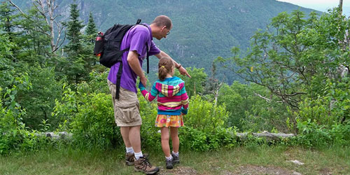
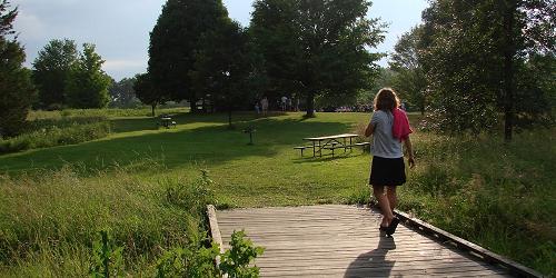
# Parks, towns, and forests of Northern Vermont welcome walkers and hikers
[Vermont](https://www.visit-vermont.com/) \> [Northern](https://www.visit-vermont.com/northern/) \> [Outdoor Activities]() \> [Walking and Hiking](https://www.visit-vermont.com/northern/walking-hiking/)
[](https://www.intervale.org/activities-events)
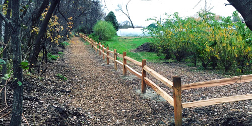
##### [Intervale Center Trails](https://www.intervale.org/activities-events)
180 Intervale Road Burlington, VT, 05401 Phone: 802-660-0440
This farm- and food-loving organization declares a mission of strengthening community food systems. Among its many offerings is to welcome people to the outdoors. The Intervale is open to the public every day. Recreational trails wind along the Winooski River to the [Ethan Allen Homestead](https://ethanallenhomestead.org/). They are used for biking, walking, and jogging, In winter, three miles of cross-country ski trails are groomed for classic and skate skiers. Bicyclists: Intervale roads are part of [Cycle the City](https://www.localmotion.org/cycle_city), a self-guided loop that winds through Burlington and the Ethan Allen Homestead, up to the University of Vermont and downtown Burlington. - [Trail Map (PDF)](https://static1.squarespace.com/static/5877a359f5e231f7a6d2b622/t/5f68e2745a651556251d3935/1600709243129/Trail+Map+Inside.pdf)
**Parking:** Visitors to the Intervale Center may park at two public parking lots off of Intervale Road, or in the lot across the street from Gardener’s Supply, at 128 Intervale Road.
[](https://www.trailfinder.info/trails/trail/gillespie-copp-welch-trails)
##### [Gillespie/Copp-Welch Trails](https://www.trailfinder.info/trails/trail/gillespie-copp-welch-trails)
Off Gilman or Lewis Creek Road Hinesburg, VT, 05461 Phone:
Easy-to moderate level foot trails on a 3-mile loop a few miles southeast of Hinesburg Village center. Trails pass through forest and fields. Good for hiking, cross-country skiing, snowshoeing, and horseback riding. Part of the [Hinesburg Area Recreational Trails system](https://www.hinesburg.org/trails-committee/pages/hinesburg-area-recreational-trails-hart), managed by the Hinesburg Town Trails Committee.
**The Trail**: Parked dirt, grass and meadow. Loop trail. Three miles.
**Access**: via Gilman Road or Lewis Creek Road.
[](https://vtstateparks.com/elmore.html)
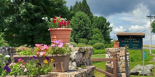
##### [Elmore State Park’s Fire Tower and Balanced Rock Trails](https://vtstateparks.com/elmore.html)
856 VT Route 12 Lake Elmore, VT, 05657 Phone: 802-888-2982
Mix of easy and moderate walks 0.5 to 1.25 miles; some good for kids
There is a variety of trails to explore, from easy to moderate to difficult. Mountain Brook Nature Trail is approximately 0.5 mile in length (about 30 minutes for a leisurely stroll). Printed brochure describes plant and wild life. Beaver Trail is 0.50 mile and easy. Passes through woodlands and wetlands.
Two trails in the park are rated moderate to difficult, and not for children. Elmore Mountain Trail (also called Fire Tower Trail) is 1.25 miles, ending at a fire tower with spectacular views of the Presidential Range in New Hampshire to Jay Peak and Mount Mansfield in Vermont. The Balancing Rock Trail is 0.5 miles through woodlands and along ledges, leading to a cool boulder balancing on its tip. - [Mountain Brook Nature Trail Guide (PDF)](https://vtstateparks.com/assets/pdf/elmore_mtnbrktrail.pdf)
[](https://vtstateparks.com/niquette.html)
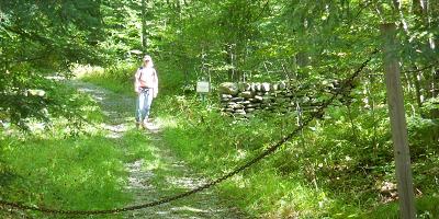
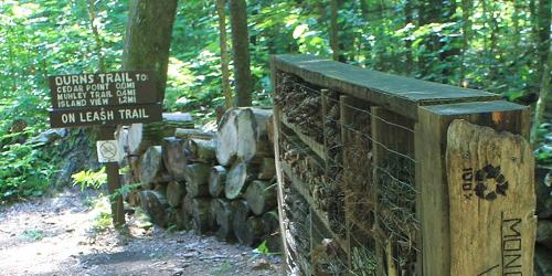
##### [Niquette Bay State Park Trails](https://vtstateparks.com/niquette.html)
274 Raymond Road Colchester, VT, 05446 Phone: 802-893-5210
Five easy or moderate walks; 0.25 to 1.50 miles; some good for kids
This state park is perched on the shore of Malletts Bay. It is an easy drive along Routes 89 or 7 to Burlington and Shelburne, to the south, or along Route 2, out to the beautiful Lake Champlain Islands, for day trips. Both places have many great attractions for adults and kids.
The park’s trails offer three loops and a variety of hiking combinations ranging from 0.6 miles to 3.5 miles. Most are rated moderate difficulty; the Burns and Allen Trails are rated easy. Views of the lake, ridges, and distant mountains. Parking is next to the park office at the entrance to the property. Pets are welcome; proof of rabies vaccination is required. The Burns, Muhley, and Island View trails are designated off-leash areas. - [Interactive Map (PDF)](https://vtstateparks.com/assets/pdf/niquette.pdf)
[](https://vtstateparks.com/smugglers.html)
##### [Smuggler's Notch State Park Trails](https://vtstateparks.com/smugglers.html)
6443 Mountain Road Stowe, VT, 05672 Phone: 802-253-4014
Moderate to difficult trails in high mountains; not for children
Smugglers' Notch is a narrow pass through the mountain with 1,000 foot cliffs. Today, it is the home of peregrine falcons and it is heavily used by hikers and ice climbers. The entrance road is passable by vehicles only in summer. A well-loved trail up the mountain is the Long Trail, which can be reached from the Notch. The Long Trail passes Elephant’s Head and Sterling Pond, a beautiful and serene mountain lake. The Hell Brook Trail is a shorter but much steeper route to the summit of Mount Mansfield. - [Trail Map (PDF)](https://vtstateparks.com/assets/pdf/smuggstrails.pdf)
[](https://vtstateparks.com/knightpoint.html)
##### [Knight Point State Park](https://vtstateparks.com/knightpoint.html)
44 Knight Point Road North Hero, VT, 05474 Phone: 802-372-8389
Easy walk; one mile; good for kids
This easy, one-mile trail skirts one point of Knight Point State Park, which is located at the southern end of North Hero Island, one of the Lake Champlain Islands. The trail passes through woodland and along the shore, offering views of the lake and lots of boat traffic. The Lake Champlain Islands are the closest image of Heaven you are likely to find anywhere. Twisty roads through rural areas and small towns offer beautiful views of the lake and distant mountain tops on all sides. - [Interactive Map (PDF)](https://vtstateparks.com/assets/pdf/knightpoint.pdf)
[](https://vtstateparks.com/underhill.html)
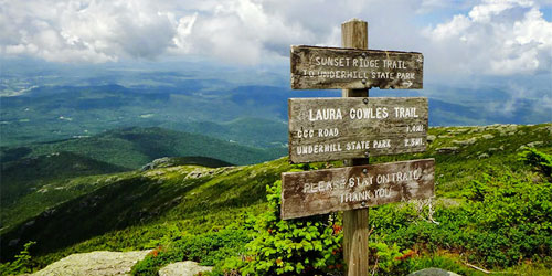
##### [Underhill State Park Trails](https://vtstateparks.com/underhill.html)
352 Mountain Road Underhill, VT, 05490 Phone: 802-899-3022
Trails are moderate to difficult, to the summit of Mount Mansfield; not for kids; entrance road does not accommodate RVs, trailers, large buses
Underhill State Park is 2,000 feet above sea level on the slope of Mount Mansfield, the state’s tallest peak. From this park four hiking trails lead to the summit ridge of Mount Mansfield. The Sunset Ridge trail is the most popular.
Vermont’s Long Trail crosses the summit ridge and provides many hiking loops on both slopes of the mountain. The ridgeline is above tree line, and plants in this area are of the alpine tundra varieties. The ridge offers views of Lake Champlain and the mountains of New York. - [Interactive Trail Map (PDF)](https://vtstateparks.com/assets/pdf/underhilltrails.pdf)
[](https://www.burlingtoncityarts.org/whale-tails)
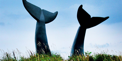
##### [Whales Tails Walking Path](https://www.burlingtoncityarts.org/whale-tails)
30 Community Drive - Technology Park Williston, VT, 05403 Phone:
This easy, 1.7-mile loop travels around the 13-foot-tall Whale Tails sculpture, a familiar sight off of I-89 south of Burlington. The granite sculpture, created by Jim Sardonis, was a finalist for a museum front in Anchorage, Alaska. The sculpture's title, "Reverence," is meant to evoke the fragility of the planet.It now occupies the property of Technology Park and is the centerpiece of a walking path. Nice walk for photographers; Vermont whales are rare and these two fellows are very popular. Photo Credit: Michael Weizenegger
[](https://vtstateparks.com/waterbury.html)
##### [Peninsula Nature Trail at Waterbury Center State Park](https://vtstateparks.com/waterbury.html)
177 Reservoir Road Waterbury Center, VT, 05677 Phone: 802-244-1226
Waterbury Center State Park lies on the Waterbury Reservoir, a quarter mile off VT Route 100. The park is open from Memorial Day to the second week of October. This walk is about one-half mile and easy. Good for kids. - [Nature Trail Map (PDF)](https://vtstateparks.com/assets/pdf/waterbury-center-nature-trail.pdf)
[](https://vtstateparks.com/philo.html)
##### [Mount Philo State Park](https://vtstateparks.com/philo.html)
5425 Humphreys' Road Charlotte, VT, 05445 Phone: 802-425-2390
Park on a mountain top has magnificent views; camping; hiking; pets allowed
This park atop Mount Philo has magnificent views. There are hiking trails from the mountain base to the summit. The main trail enters the woods off the park road and proceeds uphill to House Rock. One-half mile up the main trail, an offshoot trail goes to the right to Devil’s Chair, a huge boulder. The summit ledges and picnic area are a short, steep climb. Use blue blazes. - [Trail Guide (PDF)](https://www.vtstateparks.com/assets/pdf/PhiloTrailBrochure2021.pdf)
[](https://www.stowerec.org/parks-facilities/rec-paths/stowe-recreation-path/)
##### [Stowe Recreational Path](https://www.stowerec.org/parks-facilities/rec-paths/stowe-recreation-path/)
Along Mountain Road (Route 108) Stowe, VT Phone: 802-253-2264
Total Length: 5.3 Miles
The Stowe Recreation Path is an easy walking trail that winds through the Village of Stowe and crosses the West Branch River. The 5.5-mile one-way path (not loop) is paved and easy to reach. It is open all year, for walking, running, cycling, Nordic skiing and snowshoeing. Stay out of the groomed ski tracks during the winter. Dogs allowed on leash.
**Access Points:** Lintilhac Park behind the Stowe Community Church on Main Street; Chase Park across from Stony Brook Condominiums on Luce Hill Road; Thompson Park off Route 108 across from the Percy Farm Corn Maze; Topnotch access off Brook Road, just past Topnotch Resort on Route 108.
#### Destinations
***
[All New England](https://www.visitnewengland.com/)
[Connecticut](https://www.visitconnecticut.com/)
[Maine](https://www.visit-maine.com/)
[Massachusetts](https://www.visit-massachusetts.com/)
[New Hampshire](https://www.visit-newhampshire.com/)
[Rhode Island](https://www.visitri.com/)
[Vermont](https://www.visit-vermont.com/)
[State Map](https://www.visit-vermont.com/state/vtmap/)
#### Company
***
[About Us](https://www.visitnewengland.com/all/about-us/)
[Contact](https://www.visitnewengland.com/all/contact/)
[Privacy Policy](https://www.visitnewengland.com/all/privacy/)
[Terms and Conditions](https://www.visitnewengland.com/all/termsofuse/)
[Copyright](https://www.visitnewengland.com/all/copyright/)
[Site Map](https://www.visit-vermont.com/site-map/)
#### Partnership
***
[Advertise](https://www.visitnewengland.com/all/how_to_advertise/)
[Submit a Listing](https://share.hsforms.com/2ckIKGat7QBy3mFhOI2Cktgruw6c/)
[Submit an Event](https://www.visitnewengland.com/submit-event/)
#### Top Articles
***
[Great Things To Do](https://www.visitnewengland.com/all/great-things-to-do-in-new-england/)
[Fairs and Festivals](https://www.visitnewengland.com/all/fairs-and-festivals/)
[Family Activities](https://www.visitnewengland.com/all/family-activities/)
[Winter Activities](https://www.visitnewengland.com/all/winter-activities/)
[Fall Foliage](https://www.visitnewengland.com/all/fall-foliage-in-new-england/)
[Pet Friendly Lodging](https://www.visitnewengland.com/all/pet-and-dog-friendly/)
[Romantic Gateways](https://www.visitnewengland.com/all/romantic-getaways/)
[Waterfront Lodging](https://www.visitnewengland.com/all/waterfront-lodging/)
***
TM © 2026 Travel Media Group LLC & Visit New England®. All rights reserved. [Top](https://www.visit-vermont.com/northern/walking-hiking/#top) |
| Readable Markdown | [](https://www.intervale.org/activities-events)
##### [Intervale Center Trails](https://www.intervale.org/activities-events)
180 Intervale Road Burlington, VT, 05401 Phone: 802-660-0440
This farm- and food-loving organization declares a mission of strengthening community food systems. Among its many offerings is to welcome people to the outdoors. The Intervale is open to the public every day. Recreational trails wind along the Winooski River to the [Ethan Allen Homestead](https://ethanallenhomestead.org/). They are used for biking, walking, and jogging, In winter, three miles of cross-country ski trails are groomed for classic and skate skiers. Bicyclists: Intervale roads are part of [Cycle the City](https://www.localmotion.org/cycle_city), a self-guided loop that winds through Burlington and the Ethan Allen Homestead, up to the University of Vermont and downtown Burlington. - [Trail Map (PDF)](https://static1.squarespace.com/static/5877a359f5e231f7a6d2b622/t/5f68e2745a651556251d3935/1600709243129/Trail+Map+Inside.pdf)
**Parking:** Visitors to the Intervale Center may park at two public parking lots off of Intervale Road, or in the lot across the street from Gardener’s Supply, at 128 Intervale Road.
[](https://www.trailfinder.info/trails/trail/gillespie-copp-welch-trails)
##### [Gillespie/Copp-Welch Trails](https://www.trailfinder.info/trails/trail/gillespie-copp-welch-trails)
Off Gilman or Lewis Creek Road Hinesburg, VT, 05461 Phone:
Easy-to moderate level foot trails on a 3-mile loop a few miles southeast of Hinesburg Village center. Trails pass through forest and fields. Good for hiking, cross-country skiing, snowshoeing, and horseback riding. Part of the [Hinesburg Area Recreational Trails system](https://www.hinesburg.org/trails-committee/pages/hinesburg-area-recreational-trails-hart), managed by the Hinesburg Town Trails Committee.
**The Trail**: Parked dirt, grass and meadow. Loop trail. Three miles.
**Access**: via Gilman Road or Lewis Creek Road.
[](https://vtstateparks.com/elmore.html)
##### [Elmore State Park’s Fire Tower and Balanced Rock Trails](https://vtstateparks.com/elmore.html)
856 VT Route 12 Lake Elmore, VT, 05657 Phone: 802-888-2982
Mix of easy and moderate walks 0.5 to 1.25 miles; some good for kids
There is a variety of trails to explore, from easy to moderate to difficult. Mountain Brook Nature Trail is approximately 0.5 mile in length (about 30 minutes for a leisurely stroll). Printed brochure describes plant and wild life. Beaver Trail is 0.50 mile and easy. Passes through woodlands and wetlands.
Two trails in the park are rated moderate to difficult, and not for children. Elmore Mountain Trail (also called Fire Tower Trail) is 1.25 miles, ending at a fire tower with spectacular views of the Presidential Range in New Hampshire to Jay Peak and Mount Mansfield in Vermont. The Balancing Rock Trail is 0.5 miles through woodlands and along ledges, leading to a cool boulder balancing on its tip. - [Mountain Brook Nature Trail Guide (PDF)](https://vtstateparks.com/assets/pdf/elmore_mtnbrktrail.pdf)
[](https://vtstateparks.com/niquette.html)
##### [Niquette Bay State Park Trails](https://vtstateparks.com/niquette.html)
274 Raymond Road Colchester, VT, 05446 Phone: 802-893-5210
Five easy or moderate walks; 0.25 to 1.50 miles; some good for kids
This state park is perched on the shore of Malletts Bay. It is an easy drive along Routes 89 or 7 to Burlington and Shelburne, to the south, or along Route 2, out to the beautiful Lake Champlain Islands, for day trips. Both places have many great attractions for adults and kids.
The park’s trails offer three loops and a variety of hiking combinations ranging from 0.6 miles to 3.5 miles. Most are rated moderate difficulty; the Burns and Allen Trails are rated easy. Views of the lake, ridges, and distant mountains. Parking is next to the park office at the entrance to the property. Pets are welcome; proof of rabies vaccination is required. The Burns, Muhley, and Island View trails are designated off-leash areas. - [Interactive Map (PDF)](https://vtstateparks.com/assets/pdf/niquette.pdf)
[](https://vtstateparks.com/smugglers.html)
##### [Smuggler's Notch State Park Trails](https://vtstateparks.com/smugglers.html)
6443 Mountain Road Stowe, VT, 05672 Phone: 802-253-4014
Moderate to difficult trails in high mountains; not for children
Smugglers' Notch is a narrow pass through the mountain with 1,000 foot cliffs. Today, it is the home of peregrine falcons and it is heavily used by hikers and ice climbers. The entrance road is passable by vehicles only in summer. A well-loved trail up the mountain is the Long Trail, which can be reached from the Notch. The Long Trail passes Elephant’s Head and Sterling Pond, a beautiful and serene mountain lake. The Hell Brook Trail is a shorter but much steeper route to the summit of Mount Mansfield. - [Trail Map (PDF)](https://vtstateparks.com/assets/pdf/smuggstrails.pdf)
[](https://vtstateparks.com/knightpoint.html)
##### [Knight Point State Park](https://vtstateparks.com/knightpoint.html)
44 Knight Point Road North Hero, VT, 05474 Phone: 802-372-8389
Easy walk; one mile; good for kids
This easy, one-mile trail skirts one point of Knight Point State Park, which is located at the southern end of North Hero Island, one of the Lake Champlain Islands. The trail passes through woodland and along the shore, offering views of the lake and lots of boat traffic. The Lake Champlain Islands are the closest image of Heaven you are likely to find anywhere. Twisty roads through rural areas and small towns offer beautiful views of the lake and distant mountain tops on all sides. - [Interactive Map (PDF)](https://vtstateparks.com/assets/pdf/knightpoint.pdf)
[](https://vtstateparks.com/underhill.html)
##### [Underhill State Park Trails](https://vtstateparks.com/underhill.html)
352 Mountain Road Underhill, VT, 05490 Phone: 802-899-3022
Trails are moderate to difficult, to the summit of Mount Mansfield; not for kids; entrance road does not accommodate RVs, trailers, large buses
Underhill State Park is 2,000 feet above sea level on the slope of Mount Mansfield, the state’s tallest peak. From this park four hiking trails lead to the summit ridge of Mount Mansfield. The Sunset Ridge trail is the most popular.
Vermont’s Long Trail crosses the summit ridge and provides many hiking loops on both slopes of the mountain. The ridgeline is above tree line, and plants in this area are of the alpine tundra varieties. The ridge offers views of Lake Champlain and the mountains of New York. - [Interactive Trail Map (PDF)](https://vtstateparks.com/assets/pdf/underhilltrails.pdf)
[](https://www.burlingtoncityarts.org/whale-tails)
##### [Whales Tails Walking Path](https://www.burlingtoncityarts.org/whale-tails)
30 Community Drive - Technology Park Williston, VT, 05403 Phone:
This easy, 1.7-mile loop travels around the 13-foot-tall Whale Tails sculpture, a familiar sight off of I-89 south of Burlington. The granite sculpture, created by Jim Sardonis, was a finalist for a museum front in Anchorage, Alaska. The sculpture's title, "Reverence," is meant to evoke the fragility of the planet.It now occupies the property of Technology Park and is the centerpiece of a walking path. Nice walk for photographers; Vermont whales are rare and these two fellows are very popular. Photo Credit: Michael Weizenegger
[](https://vtstateparks.com/waterbury.html)
##### [Peninsula Nature Trail at Waterbury Center State Park](https://vtstateparks.com/waterbury.html)
177 Reservoir Road Waterbury Center, VT, 05677 Phone: 802-244-1226
Waterbury Center State Park lies on the Waterbury Reservoir, a quarter mile off VT Route 100. The park is open from Memorial Day to the second week of October. This walk is about one-half mile and easy. Good for kids. - [Nature Trail Map (PDF)](https://vtstateparks.com/assets/pdf/waterbury-center-nature-trail.pdf)
[](https://vtstateparks.com/philo.html)
##### [Mount Philo State Park](https://vtstateparks.com/philo.html)
5425 Humphreys' Road Charlotte, VT, 05445 Phone: 802-425-2390
Park on a mountain top has magnificent views; camping; hiking; pets allowed
This park atop Mount Philo has magnificent views. There are hiking trails from the mountain base to the summit. The main trail enters the woods off the park road and proceeds uphill to House Rock. One-half mile up the main trail, an offshoot trail goes to the right to Devil’s Chair, a huge boulder. The summit ledges and picnic area are a short, steep climb. Use blue blazes. - [Trail Guide (PDF)](https://www.vtstateparks.com/assets/pdf/PhiloTrailBrochure2021.pdf)
[](https://www.stowerec.org/parks-facilities/rec-paths/stowe-recreation-path/)
##### [Stowe Recreational Path](https://www.stowerec.org/parks-facilities/rec-paths/stowe-recreation-path/)
Along Mountain Road (Route 108) Stowe, VT Phone: 802-253-2264
Total Length: 5.3 Miles
The Stowe Recreation Path is an easy walking trail that winds through the Village of Stowe and crosses the West Branch River. The 5.5-mile one-way path (not loop) is paved and easy to reach. It is open all year, for walking, running, cycling, Nordic skiing and snowshoeing. Stay out of the groomed ski tracks during the winter. Dogs allowed on leash.
**Access Points:** Lintilhac Park behind the Stowe Community Church on Main Street; Chase Park across from Stony Brook Condominiums on Luce Hill Road; Thompson Park off Route 108 across from the Percy Farm Corn Maze; Topnotch access off Brook Road, just past Topnotch Resort on Route 108. |
| Shard | 147 (laksa) |
| Root Hash | 4230425678977489347 |
| Unparsed URL | com,visit-vermont!www,/northern/walking-hiking/ s443 |