ℹ️ Skipped - page is already crawled
| Filter | Status | Condition | Details |
|---|---|---|---|
| HTTP status | PASS | download_http_code = 200 | HTTP 200 |
| Age cutoff | PASS | download_stamp > now() - 6 MONTH | 0 months ago |
| History drop | PASS | isNull(history_drop_reason) | No drop reason |
| Spam/ban | PASS | fh_dont_index != 1 AND ml_spam_score = 0 | ml_spam_score=0 |
| Canonical | PASS | meta_canonical IS NULL OR = '' OR = src_unparsed | Not set |
| Property | Value |
|---|---|
| URL | https://www.nps.gov/grsm/planyourvisit/cadescove.htm |
| Last Crawled | 2026-04-19 21:36:00 (8 hours ago) |
| First Indexed | 2016-03-25 15:51:21 (10 years ago) |
| HTTP Status Code | 200 |
| Meta Title | Cades Cove - Great Smoky Mountains National Park (U.S. National Park Service) |
| Meta Description | null |
| Meta Canonical | null |
| Boilerpipe Text | NPS Photo
Cades Cove is a scenic valley surrounded on all sides by mountains south of Townsend, Tennessee. A popular 11-mile one-way loop road encircling the valley provides access to hiking trails, opportunities for wildlife viewing, and chances to explore the many historic homesites, cemeteries, and churches. The area also holds a visitor center, campground, picnic area, and riding stable.
Are you too close? Approaching wildlife endangers both humans and wildlife. Even turkeys have been known to attack humans in the Smokies, so be a friend to wildlife, and keep your distance.
Smokies Life Graphic/Emma Oxford
Touring the Cove
Cades Cove Loop Road is open sunrise to sunset each day, but
closed to vehicles each Wednesday typically from May through September
.
The 11-mile, one-way loop road circles the cove, offering motorists the opportunity to sightsee at a leisurely pace.
Allow at least two to four hours to tour Cades Cove, longer if you hike some of the area's trails.
Traffic is heavy during the tourist season in summer and fall and on weekends year-round. While driving the loop road, please be courteous to other visitors and use paved pullouts when stopping to enjoy the scenery or view wildlife.
Download the
NPS mobile app
and check out the self-guided Cades Cove driving tour for an interactive experience.
Alternative Scenic Drives
Foothills Parkway (Cosby to I-40)
: 5.6 miles (9.01 km) one-way
Foothills Parkway (Walland to Wears Valley)
: 14.75 miles (23.74 km) one-way
Foothills Parkway (Chilhowee to Walland)
: 16.6 miles (26.7 km) one-way
Places to Go in Cades Cove
Loading results...
Things to Do in Cades Cove
Loading results...
Visitor Center & Campground Information
Loading...
History
The valley has a rich
history
. For hundreds of years, Cherokee Indians hunted in Cades Cove but archeologists have found no evidence of major settlements. The first Europeans settled in the cove sometime between 1818 and 1821. By 1830, the population of the area had already swelled to 271. Cades Cove offers the widest variety of historic buildings of any area in the national park.
Scattered along the loop road are three churches, a working gristmill, barns, log houses, and many other faithfully restored eighteenth- and nineteenth-century structures. Pick up the self-guiding tour booklet available at the entrance to the loop road for information about the buildings you'll see in the cove and the people who lived here.
Cades Cove Story
Learn about farming, home life, religion, and recreation in the fascinating history of this beautiful, lively mountain community. Contains historic photos.
Self-Guiding Auto Tour Booklet Cades Cove
Keyed to numbered posts or landmarks along the Cades Cove Loop Road, this tour booklet describes the history of the Cove and describes the homes, barns, churches, Cable Mill, and other historic buildings you'll see in the area. It features historic photographs and illustrations that show what life was like a century ago.
Day Hikes In and Around Cades Cove
Map and guide with descriptions of the nine best day hikes in the Cades Cove area. Full color topo map and elevation charts.
Visit
Great Smoky Mountains National Park's official online store
for books, maps, and guides to the park. Operated by the nonprofit Smokies Life, proceeds generated by purchases at the store are donated to educational, scientific, and historical projects in the park.
Last updated: January 21, 2026 |
| Markdown | 
An official website of the United States government
Here's how you know
Here's how you know

**Official websites use .gov**
A **.gov** website belongs to an official government organization in the United States.

**Secure .gov websites use HTTPS**
A **lock** ( Locked padlock icon) or **https://** means you've safely connected to the .gov website. Share sensitive information only on official, secure websites.
- [Skip to global NPS navigation](https://www.nps.gov/grsm/planyourvisit/cadescove.htm#GlobalNav-toggle)
- [Skip to this park navigation](https://www.nps.gov/grsm/planyourvisit/cadescove.htm#LocalNav-desktop-nav)
- [Skip to the main content](https://www.nps.gov/grsm/planyourvisit/cadescove.htm#main)
- [Skip to this park information section](https://www.nps.gov/grsm/planyourvisit/cadescove.htm#ParkFooter)
- [Skip to the footer section](https://www.nps.gov/grsm/planyourvisit/cadescove.htm#GlobalFooter)
[ National Park Service](https://www.nps.gov/)
[Search](https://www.nps.gov/grsm/planyourvisit/cadescove.htm#GlobalFooterSearchInput)
# Open Menu Close Menu
## Explore This Park
## Explore the National Park Service
## Exiting nps.gov
Cancel
[Great Smoky Mountains](https://www.nps.gov/grsm/)
National Park NC, TN
- [Info](https://www.nps.gov/grsm/planyourvisit/basicinfo.htm)
- [Alerts](https://www.nps.gov/grsm/planyourvisit/conditions.htm)
- [Maps](https://www.nps.gov/grsm/planyourvisit/maps.htm)
- [Calendar](https://www.nps.gov/grsm/planyourvisit/calendar.htm)
- [Fees](https://www.nps.gov/grsm/planyourvisit/fees.htm)
#### Contact Us
# Cades Cove
| |
|---|
|  NPS Photo Cades Cove is a scenic valley surrounded on all sides by mountains south of Townsend, Tennessee. A popular 11-mile one-way loop road encircling the valley provides access to hiking trails, opportunities for wildlife viewing, and chances to explore the many historic homesites, cemeteries, and churches. The area also holds a visitor center, campground, picnic area, and riding stable. On This Page Navigation 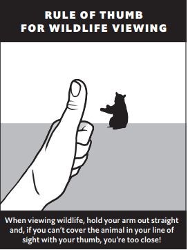 Are you too close? Approaching wildlife endangers both humans and wildlife. Even turkeys have been known to attack humans in the Smokies, so be a friend to wildlife, and keep your distance. Smokies Life Graphic/Emma Oxford Touring the Cove Cades Cove Loop Road is open sunrise to sunset each day, but [closed to vehicles each Wednesday typically from May through September](https://www.nps.gov/grsm/planyourvisit/cades-cove-vehicle-free-days.htm). The 11-mile, one-way loop road circles the cove, offering motorists the opportunity to sightsee at a leisurely pace. **Allow at least two to four hours to tour Cades Cove, longer if you hike some of the area's trails.** Traffic is heavy during the tourist season in summer and fall and on weekends year-round. While driving the loop road, please be courteous to other visitors and use paved pullouts when stopping to enjoy the scenery or view wildlife. Download the [NPS mobile app](https://www.nps.gov/subjects/digital/nps-apps.htm) and check out the self-guided Cades Cove driving tour for an interactive experience. Alternative Scenic Drives [Foothills Parkway (Cosby to I-40)](https://www.nps.gov/thingstodo/drive-foothills-parkway-cosby-to-i-40.htm): 5.6 miles (9.01 km) one-way [Foothills Parkway (Walland to Wears Valley)](https://www.nps.gov/thingstodo/drive-foothills-parkway-walland-to-wears-valley.htm): 14.75 miles (23.74 km) one-way [Foothills Parkway (Chilhowee to Walland)](https://www.nps.gov/thingstodo/drive-foothills-parkway-chilhowee-to-walland.htm): 16.6 miles (26.7 km) one-way Places to Go in Cades Cove Loading results... Things to Do in Cades Cove Loading results... Visitor Center & Campground Information Addresses Directions Hours & Seasons Amenities Contact Information Image Gallery Loading... History The valley has a rich [history](https://www.nps.gov/grsm/learn/historyculture/cades-cove-history.htm). For hundreds of years, Cherokee Indians hunted in Cades Cove but archeologists have found no evidence of major settlements. The first Europeans settled in the cove sometime between 1818 and 1821. By 1830, the population of the area had already swelled to 271. Cades Cove offers the widest variety of historic buildings of any area in the national park. Scattered along the loop road are three churches, a working gristmill, barns, log houses, and many other faithfully restored eighteenth- and nineteenth-century structures. Pick up the self-guiding tour booklet available at the entrance to the loop road for information about the buildings you'll see in the cove and the people who lived here. [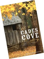](https://smokiesinformation.org/product/the-cades-cove-story/) [Cades Cove Story](https://smokiesinformation.org/product/the-cades-cove-story/) Learn about farming, home life, religion, and recreation in the fascinating history of this beautiful, lively mountain community. Contains historic photos. [](https://smokiesinformation.org/product/tour-booklet-cades-cove-tour/) [Self-Guiding Auto Tour Booklet Cades Cove](https://smokiesinformation.org/product/tour-booklet-cades-cove-tour/) Keyed to numbered posts or landmarks along the Cades Cove Loop Road, this tour booklet describes the history of the Cove and describes the homes, barns, churches, Cable Mill, and other historic buildings you'll see in the area. It features historic photographs and illustrations that show what life was like a century ago. [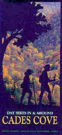](https://smokiesinformation.org/product/guidelet-cades-cove/) [Day Hikes In and Around Cades Cove](https://smokiesinformation.org/product/guidelet-cades-cove/) Map and guide with descriptions of the nine best day hikes in the Cades Cove area. Full color topo map and elevation charts. Visit [Great Smoky Mountains National Park's official online store](https://smokieslife.org/shop/) for books, maps, and guides to the park. Operated by the nonprofit Smokies Life, proceeds generated by purchases at the store are donated to educational, scientific, and historical projects in the park. |
|  |
|  |
Last updated: January 21, 2026
## Park footer
### Contact Info
#### Mailing Address:
107 Park Headquarters Road
Gatlinburg, TN 37738
#### Phone:
(865)436-1200
#### [Contact Us](https://www.nps.gov/grsm/contacts.htm)
### Tools
- [FAQ](https://www.nps.gov/grsm/faqs.htm)
- [Site Index](https://www.nps.gov/grsm/siteindex.htm)
- [Español](https://www.nps.gov/grsm/espanol/index.htm)
### Stay Connected
Experience Your America.
Download the NPS app to navigate the parks on the go.
[](https://apps.apple.com/us/app/national-park-service/id1549226484) [](https://play.google.com/store/apps/details?id=gov.nps.mobileapp)
[  ](https://www.nps.gov/)
- [Accessibility](https://www.nps.gov/aboutus/accessibility.htm)
- [Privacy Policy](https://www.nps.gov/aboutus/privacy.htm)
- [FOIA](https://www.nps.gov/aboutus/foia/index.htm)
- [Notices](https://www.nps.gov/aboutus/notices.htm)
- [Contact The National Park Service](https://www.nps.gov/aboutus/contactus.htm)
- [NPS FAQ](https://www.nps.gov/aboutus/faqs.htm "National Park Service frequently asked questions")
- [No Fear Act](https://www.doi.gov/pmb/eeo/no-fear-act)
- [Disclaimer](https://www.nps.gov/aboutus/disclaimer.htm)
- [Vulnerability Disclosure Policy](https://www.nps.gov/aboutus/vulnerability-disclosure-policy.htm)
- [USA.gov](https://www.usa.gov/)
Looking for U.S. government information and services?
[Visit USA.gov](https://www.usa.gov/) |
| Readable Markdown | | |
|---|
|  NPS Photo Cades Cove is a scenic valley surrounded on all sides by mountains south of Townsend, Tennessee. A popular 11-mile one-way loop road encircling the valley provides access to hiking trails, opportunities for wildlife viewing, and chances to explore the many historic homesites, cemeteries, and churches. The area also holds a visitor center, campground, picnic area, and riding stable.  Are you too close? Approaching wildlife endangers both humans and wildlife. Even turkeys have been known to attack humans in the Smokies, so be a friend to wildlife, and keep your distance. Smokies Life Graphic/Emma Oxford Touring the Cove Cades Cove Loop Road is open sunrise to sunset each day, but [closed to vehicles each Wednesday typically from May through September](https://www.nps.gov/grsm/planyourvisit/cades-cove-vehicle-free-days.htm). The 11-mile, one-way loop road circles the cove, offering motorists the opportunity to sightsee at a leisurely pace. **Allow at least two to four hours to tour Cades Cove, longer if you hike some of the area's trails.** Traffic is heavy during the tourist season in summer and fall and on weekends year-round. While driving the loop road, please be courteous to other visitors and use paved pullouts when stopping to enjoy the scenery or view wildlife. Download the [NPS mobile app](https://www.nps.gov/subjects/digital/nps-apps.htm) and check out the self-guided Cades Cove driving tour for an interactive experience. Alternative Scenic Drives [Foothills Parkway (Cosby to I-40)](https://www.nps.gov/thingstodo/drive-foothills-parkway-cosby-to-i-40.htm): 5.6 miles (9.01 km) one-way [Foothills Parkway (Walland to Wears Valley)](https://www.nps.gov/thingstodo/drive-foothills-parkway-walland-to-wears-valley.htm): 14.75 miles (23.74 km) one-way [Foothills Parkway (Chilhowee to Walland)](https://www.nps.gov/thingstodo/drive-foothills-parkway-chilhowee-to-walland.htm): 16.6 miles (26.7 km) one-way Places to Go in Cades Cove Loading results... Things to Do in Cades Cove Loading results... Visitor Center & Campground Information Loading... History The valley has a rich [history](https://www.nps.gov/grsm/learn/historyculture/cades-cove-history.htm). For hundreds of years, Cherokee Indians hunted in Cades Cove but archeologists have found no evidence of major settlements. The first Europeans settled in the cove sometime between 1818 and 1821. By 1830, the population of the area had already swelled to 271. Cades Cove offers the widest variety of historic buildings of any area in the national park. Scattered along the loop road are three churches, a working gristmill, barns, log houses, and many other faithfully restored eighteenth- and nineteenth-century structures. Pick up the self-guiding tour booklet available at the entrance to the loop road for information about the buildings you'll see in the cove and the people who lived here. [](https://smokiesinformation.org/product/the-cades-cove-story/) [Cades Cove Story](https://smokiesinformation.org/product/the-cades-cove-story/) Learn about farming, home life, religion, and recreation in the fascinating history of this beautiful, lively mountain community. Contains historic photos. [](https://smokiesinformation.org/product/tour-booklet-cades-cove-tour/) [Self-Guiding Auto Tour Booklet Cades Cove](https://smokiesinformation.org/product/tour-booklet-cades-cove-tour/) Keyed to numbered posts or landmarks along the Cades Cove Loop Road, this tour booklet describes the history of the Cove and describes the homes, barns, churches, Cable Mill, and other historic buildings you'll see in the area. It features historic photographs and illustrations that show what life was like a century ago. [](https://smokiesinformation.org/product/guidelet-cades-cove/) [Day Hikes In and Around Cades Cove](https://smokiesinformation.org/product/guidelet-cades-cove/) Map and guide with descriptions of the nine best day hikes in the Cades Cove area. Full color topo map and elevation charts. Visit [Great Smoky Mountains National Park's official online store](https://smokieslife.org/shop/) for books, maps, and guides to the park. Operated by the nonprofit Smokies Life, proceeds generated by purchases at the store are donated to educational, scientific, and historical projects in the park. |
|  |
|  |
Last updated: January 21, 2026 |
| Shard | 178 (laksa) |
| Root Hash | 15295459661596634578 |
| Unparsed URL | gov,nps!www,/grsm/planyourvisit/cadescove.htm s443 |