ℹ️ Skipped - page is already crawled
| Filter | Status | Condition | Details |
|---|---|---|---|
| HTTP status | PASS | download_http_code = 200 | HTTP 200 |
| Age cutoff | PASS | download_stamp > now() - 6 MONTH | 4.5 months ago (distributed domain, exempt) |
| History drop | PASS | isNull(history_drop_reason) | No drop reason |
| Spam/ban | PASS | fh_dont_index != 1 AND ml_spam_score = 0 | ml_spam_score=0 |
| Canonical | PASS | meta_canonical IS NULL OR = '' OR = src_unparsed | Not set |
| Property | Value |
|---|---|
| URL | https://www.google.com/maps/about/behind-the-scenes/streetview/treks/the-worlds-highest-peaks/ |
| Last Crawled | 2025-12-03 05:19:13 (4 months ago) |
| First Indexed | not set |
| HTTP Status Code | 200 |
| Meta Title | Street View Treks: Everest Base Camp – About – Google Maps |
| Meta Description | Discover the world with Google Maps. Experience Street View, 3D Mapping, turn-by-turn directions, indoor maps and more across your devices. |
| Meta Canonical | null |
| Boilerpipe Text | Inspired by their love of mountaineering, four Googlers decided go on a trip to Everest Base Camp in 2011. Before leaving they learned they could capture imagery of the trip for Google Maps with a tripod and digital camera, and make the photos... Read more |
| Markdown | # [Maps](https://www.google.com/maps/about/)
- [Meet Maps Explore the new Google Maps.](https://www.google.com/maps/about/)
- [Playground Discover the social side of Maps.](https://www.google.com/maps/about/play/)
- [Local Guides Earn rewards by contributing to Maps.](https://www.google.com/local/guides/signup?hl=en&utm_campaign=geo-maps_about&utm_source=google&utm_medium=maps_promo)
- [Google Maps Treks Journey beyond the road.](https://www.google.com/maps/about/treks/)
- [Street View See the world from every angle.](https://www.google.com/streetview/)
- [Indoor Maps Integrate your floor plans with Google Maps.](https://www.google.com/maps/about/partners/indoormaps/)
- [My Maps Create and share custom maps.](https://www.google.com/maps/about/mymaps/)
[Download Google Maps](https://itunes.apple.com/app/id585027354)
# Everest Base Camp, Nepal
Climb to Everest Base Camp
# A closer look at Everest Base Camp
***
Inspired by their love of mountaineering, four Googlers decided go on a trip to Everest Base Camp in 2011. Before leaving they learned they could capture imagery of the trip for Google Maps with a tripod and digital camera, and make the photos... [Read more]()
[Explore in Street View](https://www.google.com/maps/views/streetview/the-worlds-highest-peaks?hl=en)


- [Zoom In]()
- [Zoom Out]()
# View from South Base Camp
[Explore more 360º panoramic images in Views](https://www.google.com/maps/views/streetview/the-worlds-highest-peaks?hl=en)
| | |
|---|---|
| `←` | Move left |
| `→` | Move right |
| `↑` | Move up |
| `↓` | Move down |
| `+` | Zoom in |
| `-` | Zoom out |

This image is no longer available

Keyboard shortcuts
Map Data
Image may be subject to copyright
[Terms](https://www.google.com/intl/en_US/help/terms_maps.html)
[Report a problem]("Report problems with Street View imagery to Google")
- [Zoom In]()
- [Zoom Out]()
# Experience the journey

Day 1: The team starts their adventure in Lukla, Nepal. From left: Andrew, Sara, Dan, Mike and Sam.

Day 4: On a lunch break, Dan and a porter named Jit pose in front of the monastery in the village of Tengboche.

A Street View image of Tengboche Monastery.

Day 5: The team woke in the village of Pangboche to the sun shining and this beautiful view of the peak of Ama Dablam.

Day 6: The team takes a rest day to acclimatize in Dingboche. The day is spent playing cards, checking internet (!) and taking in the view.

Day 8: The exhausted group reaches Gorak Shep in the morning, and pushes on to finally reach their destination: Everest Base Camp.

Day 8: Success! The triumphant climbers gather for a photo at the base of the top of the world.
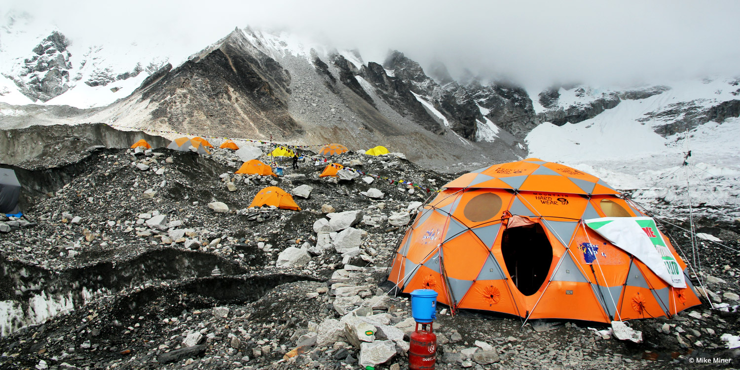
Day 8: A Japanese expedition had set up camp with a series of tents, generators, communication equipment and a mess hall.

Day 8: More than three miles above sea level (and with only half the oxygen) Dan gets to work capturing photos of Base Camp.

Day 11: On the last day the team wakes in the village of Namche Bazaar and does their last hike back to the starting point in Lukla.
- 1
- 2
- 3
- 4
- 5
- 6
- 7
- 8
- 9
- 10
- ←
- →
# Explore more views of Everest Base Camp
[Explore in Street View](https://www.google.com/maps/views/streetview/the-worlds-highest-peaks?hl=en)
Follow us on:
[Blog](https://google-latlong.blogspot.com/) [Help](https://support.google.com/maps/?hl=en)
- About
- [Meet Maps](https://www.google.com/maps/about/)
- [Street View](https://www.google.com/streetview/)
- [My Maps](https://www.google.com/maps/about/mymaps/)
- [Privacy & Security](https://www.google.com/streetview/privacy/)
- Contribute
- [Local Guides](https://www.google.com/local/guides/signup?hl=en&utm_campaign=geo-maps_about&utm_source=google&utm_medium=maps_promo)
- [Indoor Maps](https://www.google.com/maps/about/partners/indoormaps/)
- [Create Street View](https://www.google.com/streetview/publish/)
- [Hire a Street View Pro](https://www.google.com/streetview/hire/)
- [Become a Trekker](https://g.co/trekker)
- [SV Partner Program](https://www.google.com/maps/about/partners/)
- Play
- [Overview](https://www.google.com/maps/about/play/)
- Explore
- [View all Treks](https://www.google.com/maps/about/behind-the-scenes/streetview/treks/)
Change language:
- [Google](https://www.google.com/)
- [About Google](https://www.google.com/intl/en/about/?utm_source=maps.google.com&utm_medium=referral&utm_campaign=maps-footer-en)
- [Privacy](https://www.google.com/intl/en/policies/privacy/)
- [Terms](https://www.google.com/intl/en/policies/terms/) |
| Readable Markdown | null |
| Shard | 95 (laksa) |
| Root Hash | 744624608793826895 |
| Unparsed URL | com,google!www,/maps/about/behind-the-scenes/streetview/treks/the-worlds-highest-peaks/ s443 |