ℹ️ Skipped - page is already crawled
| Filter | Status | Condition | Details |
|---|---|---|---|
| HTTP status | PASS | download_http_code = 200 | HTTP 200 |
| Age cutoff | PASS | download_stamp > now() - 6 MONTH | 0 months ago |
| History drop | PASS | isNull(history_drop_reason) | No drop reason |
| Spam/ban | PASS | fh_dont_index != 1 AND ml_spam_score = 0 | ml_spam_score=0 |
| Canonical | PASS | meta_canonical IS NULL OR = '' OR = src_unparsed | Not set |
| Property | Value |
|---|---|
| URL | https://www.coloradohikesandhops.com/blog/hiking-salt-lake-city-area |
| Last Crawled | 2026-04-20 20:58:19 (1 day ago) |
| First Indexed | 2024-07-10 03:51:15 (1 year ago) |
| HTTP Status Code | 200 |
| Meta Title | Best Hikes In Salt Lake City, Utah — Colorado Hikes and Hops |
| Meta Description | The best hikes in Salt Lake City are just 20 minutes from downtown, offering year-round joy! With my kid at the University, I've loved exploring these trails and embracing Utah's quirky liquor laws for a post-hike brew. Hiking Salt Lake City area means well-marked trails, lush forests, and scenic views—all with the bonus of low altitude! Check out my 5 favorite hikes, top bars, and fun gear shops. |
| Meta Canonical | null |
| Boilerpipe Text | This page contains affiliate links. If you make a purchase via a link on this page, we make a small commission at absolutely no extra charge to you. Thank you for your support of this small women-led business.
My kid goes to U of Utah so I've been hiking Salt Lake City like crazy—turns out we Coloradans have been missing out because these trails are STUNNING, low altitude, and literally 20 minutes from downtown!
From Downtown to Peaks: Hiking Salt Lake City Area
Some of the best hikes in Salt Lake City are just 20 minutes from downtown, and we're sharing our favorite trails—from waterfall hikes to summit scrambles with killer views. Plus, you'll love the lower altitude compared to Colorado and we've got insider tips on parking and timing.
Some of the best hikes in Salt Lake City are within just 20 minutes of downtown. With a child attending the University, I’ve been delighted to explore this mecca of rock formations and gorgeous landscapes.
No matter the season—summer, fall, winter, or spring—hiking the Salt Lake City area is simply delightful. If you know me, I love throwing back a cold brew post hike. While the liquor laws might be a bit quirky, I gladly embrace Utah's nuances to keep enjoying its trails.
Hiking around Salt Lake City is a breeze (All Trails is my BFF), with well-marked trailheads and, most importantly, a sense of safety for solo hikers like myself.
Just like Colorado boasts countless beautiful trails, Salt Lake City offers a charming mix of forests, hills, and scenic views with the added perk of low altitude!
Below are my five standout Salt Lake hikes
.
Included are some great bars (you'll need to show your ID, as only those 21 and older can partake) and amazing outdoor gear outlets like Patagonia.
Salt Lake City Hiking - Sharing the Trail
DOGS, BIKES AND HIKERS!
On many Utah trails, there's an "implied law" about bikes, dogs, and hikers. Off-leash dogs are allowed on odd-numbered days, and dogs must be on a leash on even-numbered days. This even/odd strategy was introduced around 2001 due to the rising number of biker/off-leash dog interactions.
The tension had been building for years because of user conflicts and increased bike traffic.
It’s a quirky system, but it keeps the peace hiking around Salt Lake City!
Table of Contents
Pipeline Overlook
Grandeur Peak East Trail
Living Room Loop
Lower Falls
Via Bells Canyon Trail
Mount Van Cott via
Red Butte Canyon Trail Loop
Valley View
and Twin Peaks Loop Trail
Locals Only Trail Recs
Places to Eat
Gear Outlets
Where to Stay
What to Wear
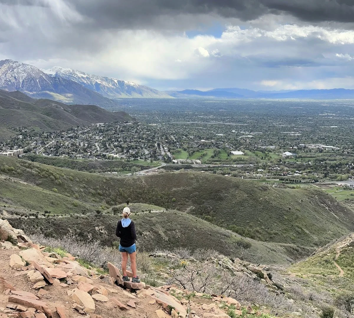
Pipeline Overlook
Pipeline Overlook via Rattlesnake Gulch
Mileage: 3.9 miles
Elevation: 823’
Ranked as a moderate hike, Pipeline Trail seems to go on forever. A friend from Utah says the Pipeline Trail is one of the best hikes in Salt Lake City for this reason. This particular section is especially gorgeous with its mountain vista views at the Gulch.
The night we hiked this trail, we caught glimpses of parasailers diving off the cliffs above us. While that sport has never been on my bucket list, if you’re into adventure, this appears to be the place for it!
NOTE!
As you enter the park, you’ll need to pay a $5 fee, at least on the weekends. When I went back during the week, I didn’t see anyone taking fees or any place to put money.
Pipeline Overlook Trail has a large parking lot, probably holding 30 cars, along with two well-kept and clean vault toilets. On a weekend around 4 p.m., the lot was full but not overwhelming. We easily got a spot and started up on the well-marked trail.
There are so many trails to explore in this area. In fact, I came back later that week to check out more side trails and spur trails.
We loved arriving a bit later in the day, putting on layers for the fast-cooling air. Hiking the Salt Lake City area in early May, the trail was relatively dry with spots of mud along the way.
Keep in mind the first 1 ½ miles are a steep and steady uphill. We hardly noticed the incline because of the low altitude and beauty along the way.
I loved the trees covering the trail, with spring just starting to bud all around us as we hiked. I can only imagine how beautiful hiking Salt Lake trails are in summer and fall.
I highly recommend you take the trail toward Pipeline Lookout. Along with mountain views, you get some stellar shots of downtown Salt Lake City and the University of Utah.
How To Get There:
Depending on where you stay, directions vary. Hop on I-215/Belt South, taking exit 4 toward Hospital. Left onto 3900 S. Left on Wasatch Blvd. Follow Mill Creek Canyon Rd to Forest Road 269.
ADDRESS:
Forest Rd 269, Salt Lake City, UT 84124
TRAIL HIGHS
Insane mountain views
Well marked trail, often wide enough for two to hike side by side
Shady in spots
TRAIL LOWS
Obvious muddy spots (Spring hiking!) and rutted trail due to mud drying
Fee to pay to use area
My #1 SOLO HIKING TIP!
Hiking alone has become one of my favorite ways to disconnect from the outside world. If you’ve wondered how safe it is to hike solo, I’ve been in your shoes! In fact, over the past few years, hiking alone has become the main way I explore new trails and places.
I’ve learned a few things on my journey,
pro tips I wish I’d known ahead of time
.
A favorite tool in my arsenal of solo hiking and backpacking is the Garmin inReach Mini. For around $400 new (or on sale/preowned for $300 or less), this small device keeps me connected to the outside world. My husband can find me on the trails with its map-sharing feature.
I send messages to him on my hikes and trips, staying in contact in case of emergency.
The Garmin inReach Mini gives the solo hiker the freedom to explore while staying safe!
Stopping to take in the views along Granduar Peak
Grandeur Peak East Trail
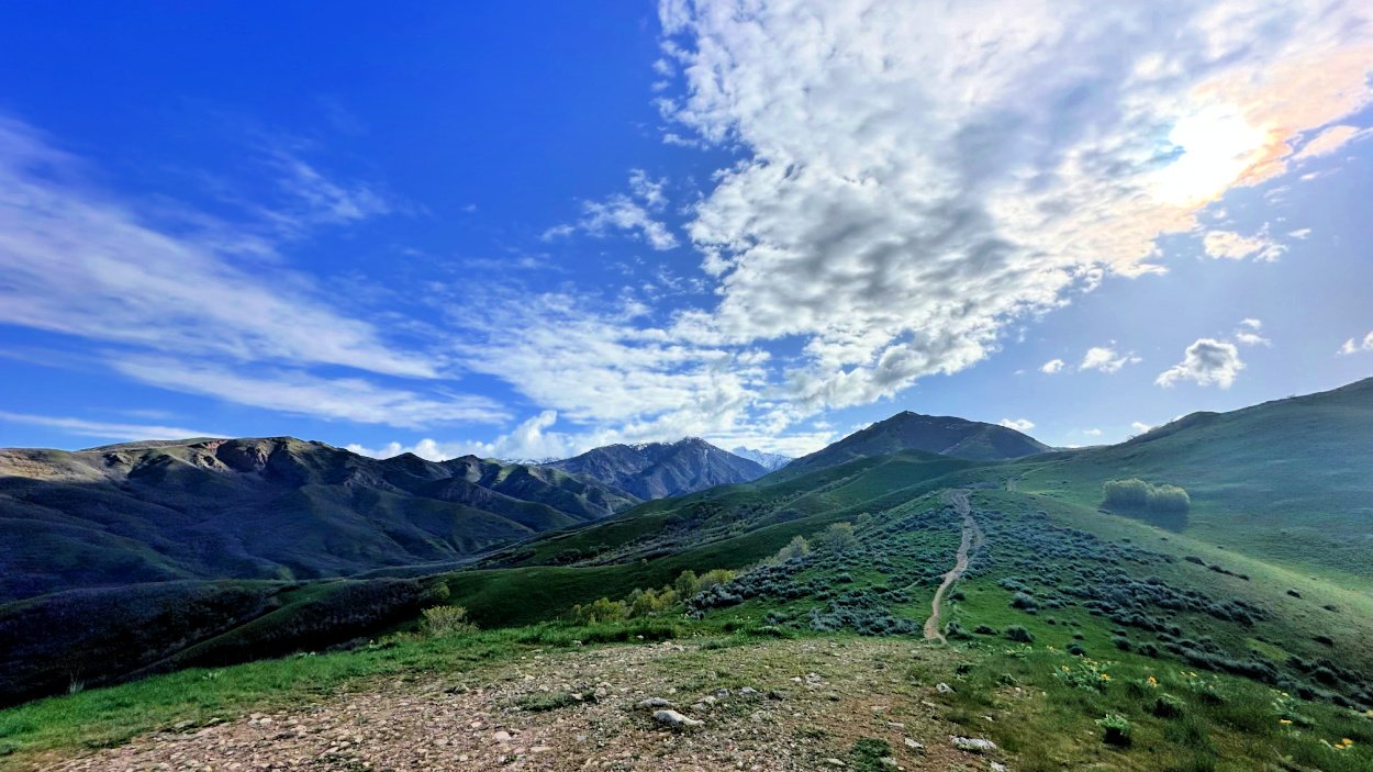
Mileage: 5.6 miles
Elevation: 2352’
Armed with 2 liters of water, snacks, a hat, gloves, and my trusty Garmin inReach Mini, I set out on hikes in Utah Salt Lake City on my own. After checking the weather report and trail conditions (snow was still a big deal on many trails in early May in Utah), I headed toward Pipeline Trail.
I arrived at the trailhead around 8:30 a.m. There's no dedicated parking area, so you have to park on the road. With two routes to the trailhead, I chose walking through a well-established picnic area with lots of signs saying, “no parking for hikers, picnickers only.”
This little detour is stunning, with water gushing down falls along the road. The paved road is an option but honestly, pick the dirt path, it’s far prettier.
Both paths lead to the large trailhead sign!
You can't miss the trailhead sign—it's a big wooden marker that starts the ascent.
Keep to the left as you hike.
This is one hike where the pictures tell the story better than words. On an early spring day, hiking around Salt Lake City felt like a dream. I passed only a handful of people during the 2 1/2 hours I was on the trail. BLISS for this introvert!
At mile 1, take the wooden steps that run alongside the waterfalls. In early May, spring was just starting, with tons of shade for summer and fall. It was a cloudy day when I went, and I loved the large trees and rushing water along the way.
Hiking to Grandeur Peak
There are a few intense uphill sections, but just as it started to get tough, the trail levels out.
Expect a rather padded, “loamy” trail for the first bit. I loved the squishy bits of plants under my feet as I hiked. The trail transitions to dirt and then to rocks—big and small.
Hiking shoes are a must for this trail. Several trail runners passed me wearing sturdy trail shoes as well.
I wished I’d had my hiking poles
for the last bit when I was sliding and sloshing through melted snow.
PRO TIP!
Unsure whether to wear hiking shoes, trail runners, or boots for Salt Lake City area hikes? We've got you covered. Learn how to
find and fit the best hiking shoes
for your needs!
The last mile to the summit is pretty challenging and steep. Keep to the left along the trail; it’s a well-worn path that's clearly marked. When I went in May, there was about a 100-foot section of very slippery snow. Coming down, I ended up on my butt for most of it.
This section was a bit unnerving, as the cliffs on either side are very steep.
How to get there
Depending on where you stay in Salt Lake City, directions vary. Hop on I-215/Belt South, taking exit 4 toward Hospital. Left onto 3900 S. Left on Wasatch Blvd. Follow Mill Creek Canyon Rd to S Church Fork.
ADDRESS:
Millcreek, Utah 84109
Trail Highs
Plenty of parking
Well marked trail signs
Spectacular Views
Shaded areas (for summer hiking)
Trail Lows
Fee to enter *it appears to be weekends only
Muddy in spring *rutted path due to shared bike trail
Salt Lake City views from the Living Room at dawn
Living Room Loop
Mileage: 2.3 miles
Elevation: 977’
As one of the most popular Salt Lake City Utah hiking areas due to its short distance and superb location near the University of Utah, the Living Room Loop is not to be mistaken for an easy hike.
It’s a great early morning or late sunset hike. Avoid the middle of the day, as the area is very exposed and heats up fast.
Grab your hiking shoes and leave the sandals at home. This hike is akin to the
Manitou Incline in Colorado
. It’s a steep trail with tons of rocky terrain. Head up the well-marked path after parking along the road by the Natural History Museum near the University of Utah.
Three-hour parking is free.
NOTE!
The Natural History Museum is worth the entrance fee! Consider stopping here post hike to brush up on earth science. Even if you’re not a history buff, the exhibits are dynamic and interesting. U of U students get in for free.
Start climbing up and then loop to the left along a switchback of sorts. Hike a bit (maybe ¼ mile) to a dirt road. Turn right and look for a wide gravel trail headed to the left. *See picture above.
Once on this trail, keep right as you work up the canyon. Going left will take you on splinter trails and not to the Living Room.
The final push is a hill. As the trail makes a significant turn to the left, your intense climbing is over. You’ll know you’ve arrived at the Living Room when you see the many rock formations placed as “stools” up there.
NOTE!
This is one hike where you should leave the headphones at home. There are runners racing down while others are huffing up. You’ll want to make sure to step aside as hiking etiquette dictates.
Hiking in the Salt Lake City area is not complete without visiting the Living Room.
We often tack on this hike as a great post-supper sunset viewing experience.
HOW TO GET THERE
From the University of Utah, head northwest on Foothills Drive. Turn right onto Wakara Way. Turn right onto S 2310 E/S Colorow Drive.
ADDRESS:
S Colorow Dr, Salt Lake City, UT 84108
Trail Highs
Easy to access near University of Utah
Well marked trail
Short distance, solid hike
Trail Lows
Very steep in areas
Very popular hike
No shade
Lower Falls
Lower Falls Via Bells Canyon Trail
Mileage: 4.8 miles
Elevation: 1515’
HIke toward the reservoir on the Bells Canyon Trail
A 20 minute ride from most parts of downtown, this is a must do Salt Lake area hike.
Lower Falls via Bells Canyon Trail one of my favorite hikes in Salt Lake City. I started around 8:30 am, with just a few cars in the lot and a peaceful trail ahead. The hike begins with gentle switchbacks, offering stunning mountain and city views.
Many families hike to the watershed a bit up the trail. It’s the perfect place to stop and let kids wander freely on the trail. You can fish but not dip in this body of water.
Bells Canyon trail is a relatively easy trek until the final mile to the waterfall, where the trail becomes rocky and you might encounter a 100-yard stretch of melting snow and ice, especially in late April/early May.
The route to the lower falls is somewhat marked and veers to the left, leading to a spectacular view of water cascading like crazy—simply gorgeous.
*Download the All Trails map before heading out. It will be helpful as you navigate the area around the falls. I attempted to head up to the upper falls but had to turn around due to solid ice and no spikes.
PRO TIP:
Always carry extra gear for spring hikes. I could have summited the Upper Falls with
my Kahtoola spikes
. Next time!
This 5-mile hike is a great mix of moderate terrain with a touch of difficulty on the final ascent. It's perfect for anyone who loves a bit of adventure.
On the way down, you'll likely pass families with little kids enjoying the hiking Salt Lake City area reservoir.
HOW TO GET THERE
Take I-215 S/Belt Route to exit 6 for 6200 S. Take 6200 S to Wasatch Blvd E, turning right onto Wasatch Blvd. Turn left onto UT -209 E. Turn right at Trailhead.
ADDRESS:
Bell Canyon Trail, Sandy, UT 84092
Trail Highs
Large parking lot
Gorgeous waterfalls
Moderate trail
Trail Lows
Snow covers upper trail *hard to find
Congested with people by reservoir
Salt Lake City hiking at its best along the Red Butte Canyon Trail
Mount Van Cott via Red Butte Canyon Trail Loop
Mileage: 4.5 miles
Elevation: 1710’
If you’re searching for epic hikes in Utah Salt Lake City, Mount Van Cott is a hidden gem just north of the University of Utah. Park your car along the road by the Natural History Museum, where you’ll find 3-hour parking (and yes, they do check, so don’t dawdle!).
Starting your adventure, the first half-mile presents a delightful challenge with hilly terrain that’s sure to give your legs a satisfying workout.
This hike is no stroll in the park; it’s a bona fide ball-buster that will have you breaking a sweat in no time, thanks to its completely exposed trail. But fear not, the counter-clockwise route is your secret weapon – it’s a gift that keeps on giving.
While the descent is steep and wild, tackling it first means you conquer the hard part right away, leaving the rest of the hike to be enjoyed at a more leisurely pace.
You’ll find yourself in serene solitude, having passed very few fellow adventurers along the way. The peace and quiet are perfect for soaking in the natural beauty and the stunning views that Salt Lake City hikes are known for.
Don’t expect to be glued to your phone, though; cell service lingers at just one bar the entire time, making this the perfect opportunity to unplug and immerse yourself in the wilderness.
Whether you’re a seasoned hiker looking for your next challenge or a curious explorer ready to discover the best hikes in Utah Salt Lake City, this trail offers an unforgettable adventure filled with whimsy and wonder.
How to Get There
From the University of Utah, head northwest on Foothills Drive. Turn right onto Wakara Way. About 3/4 mile down the road, turn right onto S 231 E/S Colorow Drive.
ADDRESS:
S Colorow Drive, Salt Lake City, UT
Trail Highs
In middle of city but feels like the country
Stunning views of Downtown Salt Lake City from the summit
Trail Lows
Very exposed hike *no shade
Super muddy after a rain *hiking shoes really help
Valley Views
Valley View and Twin Peaks Loop Trail
Mileage: 6.93 miles
Elevation: 1804’
Whimsical tree at the start of the trail
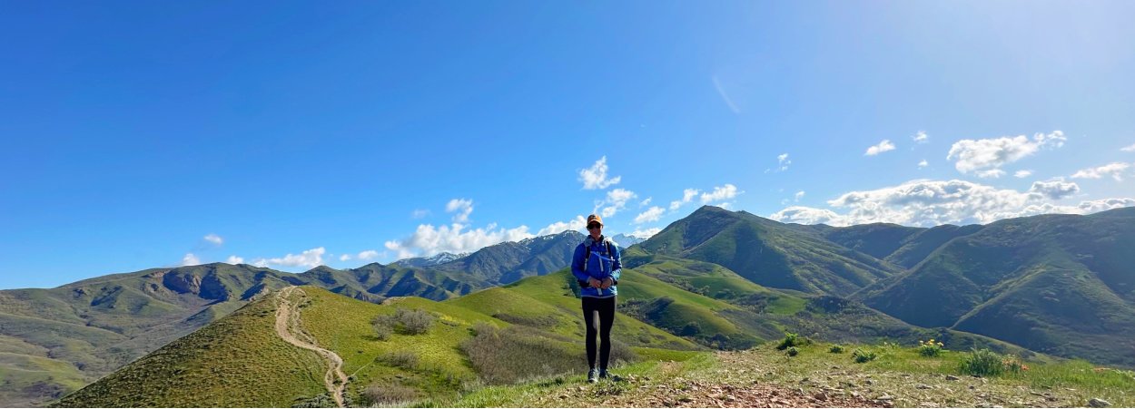
Get ready for a whimsical journey on the Valley View and Twin Peaks Loop Trail in Salt Lake City!
Start your adventure by parking in a picturesque neighborhood (just remember, no parking between 10 pm and 6 am).
As you set off on this loop hike, take the counter-clockwise route to the left and brace yourself for a steep first mile. The climb is a leg-burner, but the solitude—seeing very few hikers this direction—makes it all worth it.
Forge ahead and explore the myriad of social trails crisscrossing the area. When you reach the majestic Twin Peaks, the views will leave you breathless.
If you're feeling adventurous, continue toward Black Mountain, its summit puts you at 8,150’.
However, the dense forest and icy patches may prompt you to turn back about a quarter mile from the summit—especially without microspikes or poles. *When I hiked this early May, I had forgotten all my winter gear so had to turn around.
Despite the challenging terrain, you’ll have cell reception throughout the hike, so you can snap and share those epic views.
Complete the loop, and you’ll find the area buzzing with mountain bikers and happy, off-leash dogs. It seems the leash law here is as loose as the trails are fun!
For an unforgettable experience filled with nature’s beauty and a dash of whimsy, the Valley View and Twin Peaks Loop Trail is your go-to for hikes in Utah Salt Lake City.
How to Get There
From the University of Utah, get onto E Federal Heights Drive. Go 3/4 mile, turn left onto N Virginia Street. In about a 1/2 mile, take left onto Chandler Drive. Turn Right onto Cambridge Way, then left onto the 1st cross street onto Perrys Hollow Road N.
NOTE!
You are in a fancy neighborhood and it will feel wrong. BUT the trailhead starts at the end of the road, requiring you to park on neighborhood streets.
ADDRESS:
1100-1198 E Perrys Hollow Rd, Salt Lake City, UT 84103
Trail Highs
Stunning mountain views
Great Salt Lake City views
Trail Lows
Tons of wide and very exposed trail
Share with bikers
Trail would be super hot in the summer months *not a bit of shade
Local Recommended Hikes
Donut Falls Trail
Mileage: 1.5 miles | Elevation: 291’
Donut Falls, just a short drive from Salt Lake City, offers a family-friendly hiking adventure that leads to a unique and mesmerizing waterfall. This popular trail is bustling, especially on Friday mornings, so an early start is recommended.
You'll begin at the Donut Falls Trailhead, trekking along a well-marked path that takes you over a charming wooden bridge and through a steep boulder field, where a bit of scrambling and getting your feet wet is part of the fun. The falls, named for the donut-hole shape in the rock through which water cascades into a cave pool, are well worth the effort.
Be mindful of private property easements along the trail and ensure you stay on the designated path to help maintain public access. If the main trailhead is full or it’s winter, parking at Mill D Trailhead adds an extra mile round-trip.
Cecret Lake
Mileage: 1.8 miles | Elevation: 465’
This gorgeous hike is a short but challenging uphill trek, with rocky terrain near the top, leading to a serene and lovely lake. The trail, which has a $10 entry fee, is easy to follow but might be challenging for younger children as you get closer to the lake.
Along the way, you'll enjoy crisp, cool air, vibrant flowers, and even spot salamanders in the water. The peaceful atmosphere at the lake makes the effort worthwhile, and encountering the Tiger Salamanders adds an exciting touch to this scenic adventure.
Nomad East Pizza
COHH HOPS *Places to Eat and Gear Shop
RESTAURANTS
Nomad East
(1675 E 1300 S, Salt Lake City, UT 84105)
Full disclosure:
we eat here every single time we're in Salt Lake City visiting our son at the U of U. It's become a non-negotiable family stop — and yes, we'll keep coming back long after he graduates.
Situated in a charming neighborhood, this eatery offers both indoor and outdoor seating. The menu features incredible salads, like the smoked salmon salad with raisins, Hungarian paprika cream dressing, radishes, greens, and a sprinkle of paprika-seasoned toasted bread crumbs.
*Melody’s favorite!
Their pizzas are equally amazing; we loved the Mushroom with olive tapenade and radicchio, and the Pink Lady with Spam looked great too. Veggie options are plentiful and delightful.
Oishi Ramen
(3424 S State Street 84115) *While ramen might be the new hip thing, we are here for it! Fresh made to order bowls of broth filled with delectable ingredients hit the spot post hike!
Gourmandise
(250 South 300 East 8411) *Think French bakery meets the west. Amazing pastries, awesome brunch and great coffee!
Franklin Ave Cocktails & Kitchen
(231 S Edison St, Salt Lake City, UT 84111) *This 21-and-older bar strictly cards at the entrance, in line with UT law for bars serving food, creating a kid-free environment.
The extensive menu includes a wide selection of cocktails (try the tequila martini), a great wine list, and insane food options like sausage-stuffed olives, dill potato chips with whipped feta, a massive fried chicken sandwich, a delectable steak sandwich, and rich, satisfying chocolate pudding for dessert.
The DoDo in Sugarhouse
( 1355 E 2100 S, Salt Lake City, UT 84105) *Get the turkey sandwich. Even for this sporadic meat eater, this was the move!
USED GEAR/OUTLETS
Gear Room
(3422 Fort Union Blvd, Cottonwood Heights, UT 84121) *Discounted and well loved, almost new gear is abundant here.
Moosejaw
(470 S 900 E, Salt Lake City, UT 84102) *We love this outdoorsy store.
Patagonia Outlet
( 2292 Highland Dr., Salt Lake City, UT 84106) *The deals are hit or miss here. I was able to find a few fleece jackets for well under market price!
Where to Stay in Salt Lake City
Because of our university student, we love
staying near the University of Utah
campus. There are a plethora of vacation rental homes and hotels.
The Sugar House area has a delightful park as well as many restaurants to frequent. We love this
modern home within minutes of campus
, allowing us to walk or take the trolley into downtown Salt Lake City.
Downtown Salt Lake City is worth exploring so consider staying at
this updated apartment
within walking distance of Temple Square.
What to Wear While Hiking Salt Lake City Area
Like Colorado, Utah experiences a variety of seasons within just a few hours. The biggest difference between hiking in Colorado and Utah is the heat and altitude. Summer hiking in the Salt Lake City area is downright HOT, while spring hiking can range from freezing temps in the morning to lovely breezy moments by midday.
Another perk is that the altitude in Utah is lower than in places like Colorado Springs, making the hikes a bit easier on the lungs. You can enjoy the stunning views without feeling as winded!
Here’s a few extra things to your Salt Lake City hiking daypack!
Cooling Towel
*A must for hiking Salt Lake trails in summer months
Gaiters
*Trails can be filled with tiny pebbles that get into your shoes.
I took my Colorado Capsule Wardrobe to the Salt Lake trails and found that most of my layering worked great.
Hiking the trails in the Salt Lake City area has become one of my new favorite hobbies. While Coloradans joke about Utah residents coming over to climb their mountains, we've been missing out by not heading the other direction. With stunning low-altitude hikes and easy access to city trails, the best hikes in Salt Lake City are just minutes from the main streets.
Let us know your favorite Salt Lake City area hikes!
We can’t wait to try more!
November 21, 2025 |
| Markdown | [](https://www.coloradohikesandhops.com/)
[Home](https://www.coloradohikesandhops.com/) [Blog](https://www.coloradohikesandhops.com/blog) [Grand Canyon Rim to Rim Guide](https://www.coloradohikesandhops.com/rim-to-rim-grand-canyon-guide) [Camping Guide](https://www.coloradohikesandhops.com/colorado-campgrounds-guide) [Colorado Springs](https://www.coloradohikesandhops.com/colorado-springs) [On the Road](https://www.coloradohikesandhops.com/cohh-on-the-road) [Gear Reviews](https://www.coloradohikesandhops.com/gear-reviews) [Adventure Books](https://www.coloradohikesandhops.com/outdoor-adventure-books) [About](https://www.coloradohikesandhops.com/about-us) [Talk to Us\!](https://www.coloradohikesandhops.com/services)
[Home](https://www.coloradohikesandhops.com/)[Blog](https://www.coloradohikesandhops.com/blog)[Grand Canyon Rim to Rim Guide](https://www.coloradohikesandhops.com/rim-to-rim-grand-canyon-guide)[Camping Guide](https://www.coloradohikesandhops.com/colorado-campgrounds-guide)[Colorado Springs](https://www.coloradohikesandhops.com/colorado-springs)[On the Road](https://www.coloradohikesandhops.com/cohh-on-the-road)[Gear Reviews](https://www.coloradohikesandhops.com/gear-reviews)[Adventure Books](https://www.coloradohikesandhops.com/outdoor-adventure-books)[About](https://www.coloradohikesandhops.com/about-us)[Talk to Us\!](https://www.coloradohikesandhops.com/services)
[](https://www.coloradohikesandhops.com/)
Some of the best Colorado hiking trails and great places to eat, drink, or play after you hop off the trail.
# Best Hikes In Salt Lake City, Utah
*This page contains affiliate links. If you make a purchase via a link on this page, we make a small commission at absolutely no extra charge to you. Thank you for your support of this small women-led business.*
My kid goes to U of Utah so I've been hiking Salt Lake City like crazy—turns out we Coloradans have been missing out because these trails are STUNNING, low altitude, and literally 20 minutes from downtown\!
***

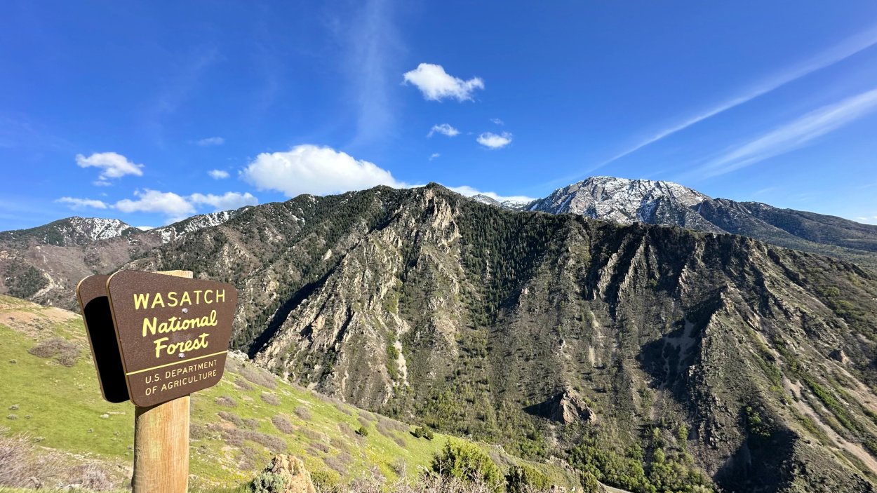
## From Downtown to Peaks: Hiking Salt Lake City Area
Some of the best hikes in Salt Lake City are just 20 minutes from downtown, and we're sharing our favorite trails—from waterfall hikes to summit scrambles with killer views. Plus, you'll love the lower altitude compared to Colorado and we've got insider tips on parking and timing.
***
View fullsize

Some of the best hikes in Salt Lake City are within just 20 minutes of downtown. With a child attending the University, I’ve been delighted to explore this mecca of rock formations and gorgeous landscapes.
No matter the season—summer, fall, winter, or spring—hiking the Salt Lake City area is simply delightful. If you know me, I love throwing back a cold brew post hike. While the liquor laws might be a bit quirky, I gladly embrace Utah's nuances to keep enjoying its trails.
Hiking around Salt Lake City is a breeze (All Trails is my BFF), with well-marked trailheads and, most importantly, a sense of safety for solo hikers like myself.
Just like Colorado boasts countless beautiful trails, Salt Lake City offers a charming mix of forests, hills, and scenic views with the added perk of low altitude\!
### **Below are my five standout Salt Lake hikes**.
Included are some great bars (you'll need to show your ID, as only those 21 and older can partake) and amazing outdoor gear outlets like Patagonia.
## Salt Lake City Hiking - Sharing the Trail
**DOGS, BIKES AND HIKERS\!** On many Utah trails, there's an "implied law" about bikes, dogs, and hikers. Off-leash dogs are allowed on odd-numbered days, and dogs must be on a leash on even-numbered days. This even/odd strategy was introduced around 2001 due to the rising number of biker/off-leash dog interactions.
The tension had been building for years because of user conflicts and increased bike traffic.
It’s a quirky system, but it keeps the peace hiking around Salt Lake City\!
## Table of Contents
### [Pipeline Overlook](https://www.coloradohikesandhops.com/blog/hiking-salt-lake-city-area#pipeline)
### [Grandeur Peak East Trail](https://www.coloradohikesandhops.com/blog/hiking-salt-lake-city-area#grandeur)
### [Living Room Loop](https://www.coloradohikesandhops.com/blog/hiking-salt-lake-city-area#living)
### [Lower Falls](https://www.coloradohikesandhops.com/blog/hiking-salt-lake-city-area#falls) Via Bells Canyon Trail
### [Mount Van Cott via](https://www.coloradohikesandhops.com/blog/hiking-salt-lake-city-area#vancott) Red Butte Canyon Trail Loop
### [Valley View](https://www.coloradohikesandhops.com/blog/hiking-salt-lake-city-area#valley) and Twin Peaks Loop Trail
### [Locals Only Trail Recs](https://www.coloradohikesandhops.com/blog/hiking-salt-lake-city-area#locals)
### [Places to Eat](https://www.coloradohikesandhops.com/blog/hiking-salt-lake-city-area#eat)
### [Gear Outlets](https://www.coloradohikesandhops.com/blog/hiking-salt-lake-city-area#gear)
### [Where to Stay](https://www.coloradohikesandhops.com/blog/hiking-salt-lake-city-area#stay)
### [What to Wear](https://www.coloradohikesandhops.com/blog/hiking-salt-lake-city-area#wear)
Pipeline Overlook
## **Pipeline Overlook via Rattlesnake Gulch**
### **Mileage: 3.9 miles**
### **Elevation: 823’**
Ranked as a moderate hike, Pipeline Trail seems to go on forever. A friend from Utah says the Pipeline Trail is one of the best hikes in Salt Lake City for this reason. This particular section is especially gorgeous with its mountain vista views at the Gulch.
The night we hiked this trail, we caught glimpses of parasailers diving off the cliffs above us. While that sport has never been on my bucket list, if you’re into adventure, this appears to be the place for it\!
**NOTE\!** As you enter the park, you’ll need to pay a \$5 fee, at least on the weekends. When I went back during the week, I didn’t see anyone taking fees or any place to put money.
Pipeline Overlook Trail has a large parking lot, probably holding 30 cars, along with two well-kept and clean vault toilets. On a weekend around 4 p.m., the lot was full but not overwhelming. We easily got a spot and started up on the well-marked trail.
There are so many trails to explore in this area. In fact, I came back later that week to check out more side trails and spur trails.
We loved arriving a bit later in the day, putting on layers for the fast-cooling air. Hiking the Salt Lake City area in early May, the trail was relatively dry with spots of mud along the way.
[View fullsize ![Trailhead Sign to Left of parking lot.]()](https://images.squarespace-cdn.com/content/v1/5f39599f0dd69335c3379b81/1718151007143-JK6J7QVWX4NTR42PMV7H/trail+sign+pipeline+trail.jpeg)
[View fullsize 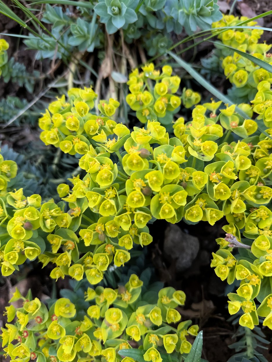![Spring flowers along the trail.]()](https://images.squarespace-cdn.com/content/v1/5f39599f0dd69335c3379b81/1718151025025-G6J0HCEBKCNDOZTG3ZT6/tiny+little+flowers.jpeg)
[View fullsize 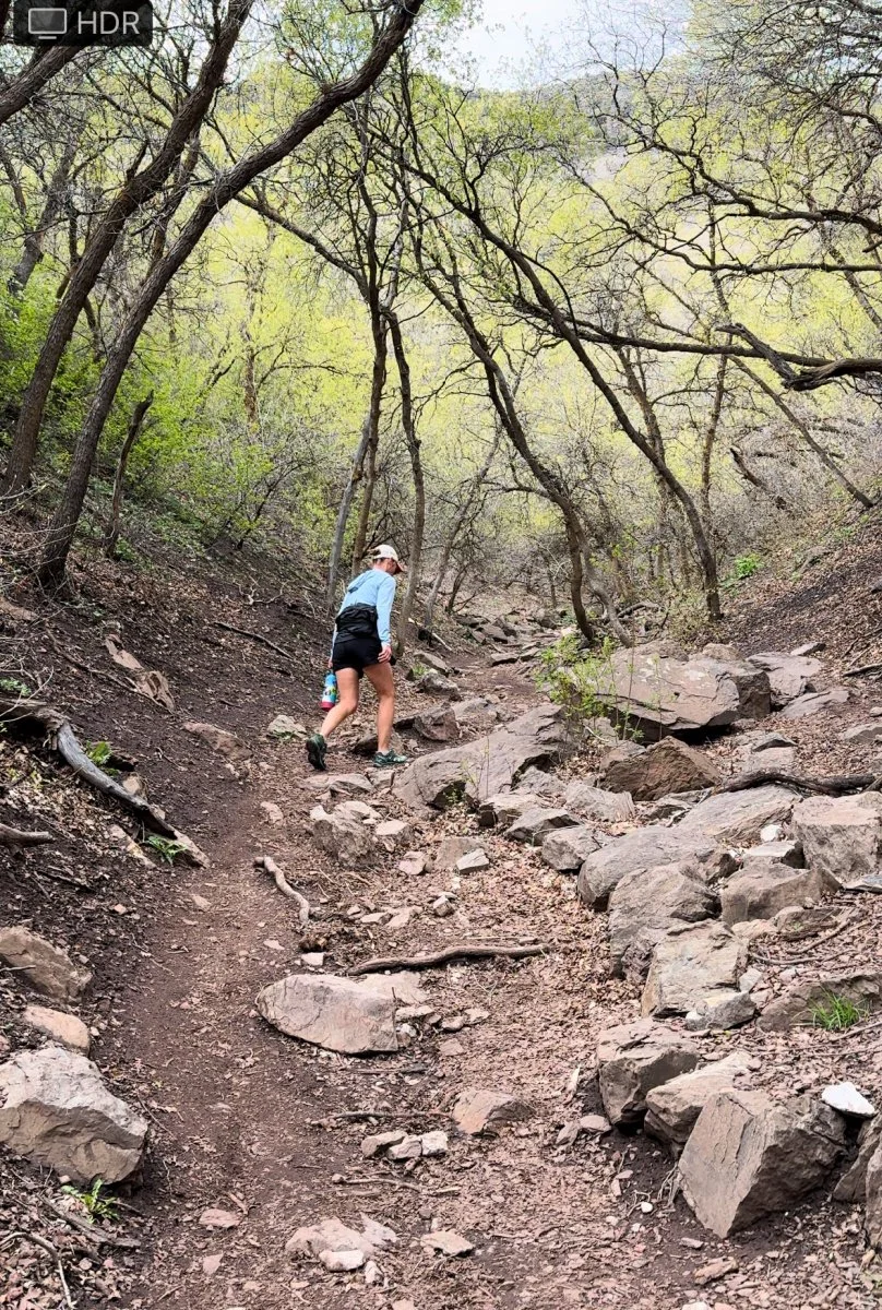![Hiking up steep first mile of hike. ]()](https://images.squarespace-cdn.com/content/v1/5f39599f0dd69335c3379b81/1718151007455-3LB97C1VQ3XDWNJTHHMU/heading+up+pipeline+trail.jpeg)
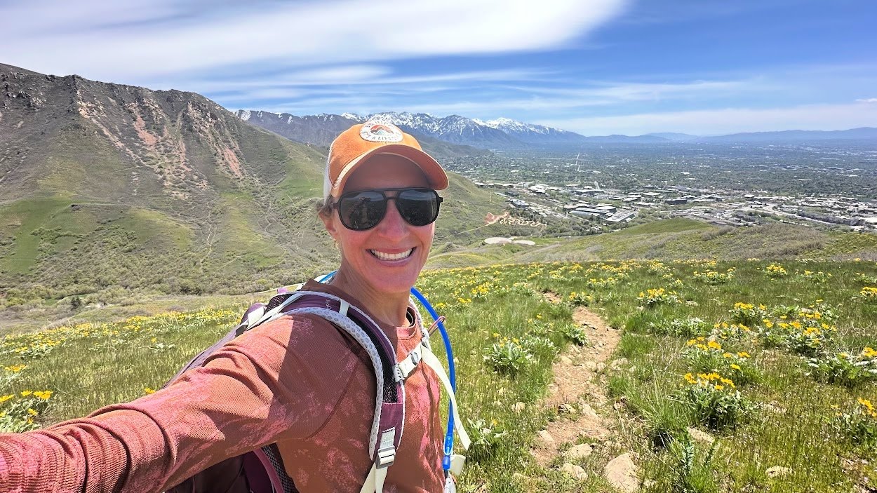
[View fullsize ![pipeline trail selfie.jpeg]()](https://images.squarespace-cdn.com/content/v1/5f39599f0dd69335c3379b81/1718288446387-PSIM7ZZKHSVV5NO41WZX/pipeline+trail+selfie.jpeg)
Keep in mind the first 1 ½ miles are a steep and steady uphill. We hardly noticed the incline because of the low altitude and beauty along the way.
I loved the trees covering the trail, with spring just starting to bud all around us as we hiked. I can only imagine how beautiful hiking Salt Lake trails are in summer and fall.
I highly recommend you take the trail toward Pipeline Lookout. Along with mountain views, you get some stellar shots of downtown Salt Lake City and the University of Utah.
### How To Get There:
Depending on where you stay, directions vary. Hop on I-215/Belt South, taking exit 4 toward Hospital. Left onto 3900 S. Left on Wasatch Blvd. Follow Mill Creek Canyon Rd to Forest Road 269.
**ADDRESS:** Forest Rd 269, Salt Lake City, UT 84124
[View fullsize ![rattlesnake trail face.jpeg]()](https://images.squarespace-cdn.com/content/v1/5f39599f0dd69335c3379b81/1718151309804-GHXIG6I8ABTZHOZSUOSZ/rattlesnake+trail+face.jpeg)
[View fullsize ![trails views pipeline trail.jpeg]()](https://images.squarespace-cdn.com/content/v1/5f39599f0dd69335c3379b81/1718151333710-RLG7LT0G9IQCA07HQ22B/trails+views+pipeline+trail.jpeg)
### TRAIL HIGHS
- Insane mountain views
- Well marked trail, often wide enough for two to hike side by side
- Shady in spots
### TRAIL LOWS
- Obvious muddy spots (Spring hiking!) and rutted trail due to mud drying
- Fee to pay to use area
[Back to the Table of Contents](https://www.coloradohikesandhops.com/blog/hiking-salt-lake-city-area#table-of-contents)
View fullsize

### My \#1 SOLO HIKING TIP\!
Hiking alone has become one of my favorite ways to disconnect from the outside world. If you’ve wondered how safe it is to hike solo, I’ve been in your shoes! In fact, over the past few years, hiking alone has become the main way I explore new trails and places.
I’ve learned a few things on my journey, [pro tips I wish I’d known ahead of time](https://www.coloradohikesandhops.com/blog/hiking-alone).
A favorite tool in my arsenal of solo hiking and backpacking is the Garmin inReach Mini. For around \$400 new (or on sale/preowned for \$300 or less), this small device keeps me connected to the outside world. My husband can find me on the trails with its map-sharing feature.
I send messages to him on my hikes and trips, staying in contact in case of emergency.
The Garmin inReach Mini gives the solo hiker the freedom to explore while staying safe\!
[Garmin inReach Mini](https://rei.pxf.io/xLzNXd)
[Back to the Table of Contents](https://www.coloradohikesandhops.com/blog/hiking-salt-lake-city-area#table-of-contents)
View fullsize

Stopping to take in the views along Granduar Peak
## **Grandeur Peak East Trail**
### **Mileage: 5.6 miles**
### **Elevation: 2352’**
Armed with 2 liters of water, snacks, a hat, gloves, and my trusty Garmin inReach Mini, I set out on hikes in Utah Salt Lake City on my own. After checking the weather report and trail conditions (snow was still a big deal on many trails in early May in Utah), I headed toward Pipeline Trail.
I arrived at the trailhead around 8:30 a.m. There's no dedicated parking area, so you have to park on the road. With two routes to the trailhead, I chose walking through a well-established picnic area with lots of signs saying, “no parking for hikers, picnickers only.”
This little detour is stunning, with water gushing down falls along the road. The paved road is an option but honestly, pick the dirt path, it’s far prettier.
[View fullsize ![Parking along the road]()](https://images.squarespace-cdn.com/content/v1/5f39599f0dd69335c3379b81/1718300112906-LP6JE41NY186FJ17JVQE/graduar+peak+trail+sign+and+road.jpeg)
[View fullsize 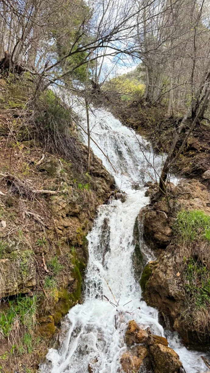![Waterfalls near the picnic area]()](https://images.squarespace-cdn.com/content/v1/5f39599f0dd69335c3379b81/1718300114197-JXP2X4XPQUQ7SDO6TF61/waterfalls+at+beginning+of+hike+grandeur+peak+trail.jpeg)
[View fullsize ![Trailhead for Grandeur Peak]()](https://images.squarespace-cdn.com/content/v1/5f39599f0dd69335c3379b81/1718300113108-PLPFET8U0SXAT0NEUA73/grandeur+peak+trail+sign+at+start.jpeg)
Both paths lead to the large trailhead sign\!
You can't miss the trailhead sign—it's a big wooden marker that starts the ascent.
Keep to the left as you hike.
This is one hike where the pictures tell the story better than words. On an early spring day, hiking around Salt Lake City felt like a dream. I passed only a handful of people during the 2 1/2 hours I was on the trail. BLISS for this introvert\!
[View fullsize ![grandeur peak trail toward summit.jpeg]()](https://images.squarespace-cdn.com/content/v1/5f39599f0dd69335c3379b81/1718300276455-OC972WPIBYJH49BG00KA/grandeur+peak+trail+toward+summit.jpeg)
[View fullsize ![more waterfalls along grandeur peak trail.jpeg]()](https://images.squarespace-cdn.com/content/v1/5f39599f0dd69335c3379b81/1718300275507-ZN98JULYYIY3XGQ93OWK/more+waterfalls+along+grandeur+peak+trail.jpeg)
[View fullsize ![views along granduer peak trail.jpeg]()](https://images.squarespace-cdn.com/content/v1/5f39599f0dd69335c3379b81/1718300275188-BA5PUF2OOOP7RCM0XRPZ/views+along+granduer+peak+trail.jpeg)
At mile 1, take the wooden steps that run alongside the waterfalls. In early May, spring was just starting, with tons of shade for summer and fall. It was a cloudy day when I went, and I loved the large trees and rushing water along the way.
Hiking to Grandeur Peak
There are a few intense uphill sections, but just as it started to get tough, the trail levels out.
Expect a rather padded, “loamy” trail for the first bit. I loved the squishy bits of plants under my feet as I hiked. The trail transitions to dirt and then to rocks—big and small.
Hiking shoes are a must for this trail. Several trail runners passed me wearing sturdy trail shoes as well.
[**I wished I’d had my hiking poles**](https://www.coloradohikesandhops.com/gear-reviews/best-hiking-poles) for the last bit when I was sliding and sloshing through melted snow.
**PRO TIP\!** Unsure whether to wear hiking shoes, trail runners, or boots for Salt Lake City area hikes? We've got you covered. Learn how to [find and fit the best hiking shoes](https://www.coloradohikesandhops.com/blog/how-to-choose-hiking-boots-shoes-trail-runners) for your needs\!
The last mile to the summit is pretty challenging and steep. Keep to the left along the trail; it’s a well-worn path that's clearly marked. When I went in May, there was about a 100-foot section of very slippery snow. Coming down, I ended up on my butt for most of it.
This section was a bit unnerving, as the cliffs on either side are very steep.
### How to get there
Depending on where you stay in Salt Lake City, directions vary. Hop on I-215/Belt South, taking exit 4 toward Hospital. Left onto 3900 S. Left on Wasatch Blvd. Follow Mill Creek Canyon Rd to S Church Fork.
**ADDRESS:** Millcreek, Utah 84109
### Trail Highs
- Plenty of parking
- Well marked trail signs
- Spectacular Views
- Shaded areas (for summer hiking)
### Trail Lows
- Fee to enter \*it appears to be weekends only
- Muddy in spring \*rutted path due to shared bike trail
[Back to the Table of Contents](https://www.coloradohikesandhops.com/blog/hiking-salt-lake-city-area#table-of-contents)
View fullsize

Salt Lake City views from the Living Room at dawn
## **Living Room Loop**
### **Mileage: 2.3 miles**
### **Elevation: 977’**
As one of the most popular Salt Lake City Utah hiking areas due to its short distance and superb location near the University of Utah, the Living Room Loop is not to be mistaken for an easy hike.
It’s a great early morning or late sunset hike. Avoid the middle of the day, as the area is very exposed and heats up fast.
Grab your hiking shoes and leave the sandals at home. This hike is akin to the [Manitou Incline in Colorado](https://www.coloradohikesandhops.com/blog/the-manitou-incline). It’s a steep trail with tons of rocky terrain. Head up the well-marked path after parking along the road by the Natural History Museum near the University of Utah.
Three-hour parking is free.
[View fullsize ![living room parking.jpeg]()](https://images.squarespace-cdn.com/content/v1/5f39599f0dd69335c3379b81/1718301790384-1166K78BALIKRZS3V3SK/living+room+parking.jpeg)
[View fullsize ![deer at dawn living room.jpeg]()](https://images.squarespace-cdn.com/content/v1/5f39599f0dd69335c3379b81/1718301790184-B6ZTY5WEV2N00KOGLOLJ/deer+at+dawn+living+room.jpeg)
[View fullsize ![sunrise over living room.jpeg]()](https://images.squarespace-cdn.com/content/v1/5f39599f0dd69335c3379b81/1718301829581-ZNM4H2VX3N3FVTB7E9CE/sunrise+over+living+room.jpeg)
**NOTE\!** The Natural History Museum is worth the entrance fee! Consider stopping here post hike to brush up on earth science. Even if you’re not a history buff, the exhibits are dynamic and interesting. U of U students get in for free.
Start climbing up and then loop to the left along a switchback of sorts. Hike a bit (maybe ¼ mile) to a dirt road. Turn right and look for a wide gravel trail headed to the left. \*See picture above.
Once on this trail, keep right as you work up the canyon. Going left will take you on splinter trails and not to the Living Room.
The final push is a hill. As the trail makes a significant turn to the left, your intense climbing is over. You’ll know you’ve arrived at the Living Room when you see the many rock formations placed as “stools” up there.
**NOTE\!** This is one hike where you should leave the headphones at home. There are runners racing down while others are huffing up. You’ll want to make sure to step aside as hiking etiquette dictates.
Hiking in the Salt Lake City area is not complete without visiting the Living Room.
We often tack on this hike as a great post-supper sunset viewing experience.
View fullsize
### HOW TO GET THERE
From the University of Utah, head northwest on Foothills Drive. Turn right onto Wakara Way. Turn right onto S 2310 E/S Colorow Drive.
**ADDRESS:** S Colorow Dr, Salt Lake City, UT 84108
### Trail Highs
- Easy to access near University of Utah
- Well marked trail
- Short distance, solid hike
### Trail Lows
- Very steep in areas
- Very popular hike
- No shade
[Back to the Table of Contents](https://www.coloradohikesandhops.com/blog/hiking-salt-lake-city-area#table-of-contents)

Lower Falls
## **Lower Falls Via Bells Canyon Trail**
### **Mileage: 4.8 miles**
### **Elevation: 1515’**

HIke toward the reservoir on the Bells Canyon Trail
A 20 minute ride from most parts of downtown, this is a must do Salt Lake area hike.
Lower Falls via Bells Canyon Trail one of my favorite hikes in Salt Lake City. I started around 8:30 am, with just a few cars in the lot and a peaceful trail ahead. The hike begins with gentle switchbacks, offering stunning mountain and city views.
Many families hike to the watershed a bit up the trail. It’s the perfect place to stop and let kids wander freely on the trail. You can fish but not dip in this body of water.
Bells Canyon trail is a relatively easy trek until the final mile to the waterfall, where the trail becomes rocky and you might encounter a 100-yard stretch of melting snow and ice, especially in late April/early May.
The route to the lower falls is somewhat marked and veers to the left, leading to a spectacular view of water cascading like crazy—simply gorgeous.
\*Download the All Trails map before heading out. It will be helpful as you navigate the area around the falls. I attempted to head up to the upper falls but had to turn around due to solid ice and no spikes.
[View fullsize ![marked trail signs bells canyon.jpg]()](https://images.squarespace-cdn.com/content/v1/5f39599f0dd69335c3379b81/1718977877407-366I6CXUNUAXABOJEA93/marked+trail+signs+bells+canyon.jpg)
[View fullsize ![trail along bells canyon trail.jpeg]()](https://images.squarespace-cdn.com/content/v1/5f39599f0dd69335c3379b81/1718977874861-7RRQP4OVD7HWX5BYPXX8/trail+along+bells+canyon+trail.jpeg)
[View fullsize ![views along bells canyon trail.jpeg]()](https://images.squarespace-cdn.com/content/v1/5f39599f0dd69335c3379b81/1718977878795-NE29WBWUOEZOFLNB7MDX/views+along+bells+canyon+trail.jpeg)
[View fullsize ![signs for upper waterfall.jpeg]()](https://images.squarespace-cdn.com/content/v1/5f39599f0dd69335c3379b81/1718977872767-PKT3GN6D7YQIH3FKXZAP/signs+for+upper+waterfall.jpeg)
**PRO TIP:** Always carry extra gear for spring hikes. I could have summited the Upper Falls with [my Kahtoola spikes](https://www.coloradohikesandhops.com/gear-reviews/micro-spikes-on-colorado-trails). Next time\!
This 5-mile hike is a great mix of moderate terrain with a touch of difficulty on the final ascent. It's perfect for anyone who loves a bit of adventure.
On the way down, you'll likely pass families with little kids enjoying the hiking Salt Lake City area reservoir.
### HOW TO GET THERE
Take I-215 S/Belt Route to exit 6 for 6200 S. Take 6200 S to Wasatch Blvd E, turning right onto Wasatch Blvd. Turn left onto UT -209 E. Turn right at Trailhead.
**ADDRESS:** Bell Canyon Trail, Sandy, UT 84092
### Trail Highs
- Large parking lot
- Gorgeous waterfalls
- Moderate trail
### Trail Lows
- Snow covers upper trail \*hard to find
- Congested with people by reservoir
[Back to the Table of Contents](https://www.coloradohikesandhops.com/blog/hiking-salt-lake-city-area#table-of-contents)
View fullsize

Salt Lake City hiking at its best along the Red Butte Canyon Trail
## **Mount Van Cott via Red Butte Canyon Trail Loop**
### **Mileage: 4.5 miles**
### **Elevation: 1710’**
If you’re searching for epic hikes in Utah Salt Lake City, Mount Van Cott is a hidden gem just north of the University of Utah. Park your car along the road by the Natural History Museum, where you’ll find 3-hour parking (and yes, they do check, so don’t dawdle!).
Starting your adventure, the first half-mile presents a delightful challenge with hilly terrain that’s sure to give your legs a satisfying workout.
This hike is no stroll in the park; it’s a bona fide ball-buster that will have you breaking a sweat in no time, thanks to its completely exposed trail. But fear not, the counter-clockwise route is your secret weapon – it’s a gift that keeps on giving.
[View fullsize ![mount van cott bridge near SLC.jpeg]()](https://images.squarespace-cdn.com/content/v1/5f39599f0dd69335c3379b81/1719006166610-VG2EBX7QNMR3JKZVO5LB/mount+van+cott+bridge+near+SLC.jpeg)
[View fullsize ![trail up to summit mount van cott.jpeg]()](https://images.squarespace-cdn.com/content/v1/5f39599f0dd69335c3379b81/1719006165798-8U3Y624MJJN7WTO614P5/trail+up+to+summit+mount+van+cott.jpeg)
[View fullsize ![resting at van cott summit.jpg]()](https://images.squarespace-cdn.com/content/v1/5f39599f0dd69335c3379b81/1719006162744-TI8HK4OHXW27VEVCOBS7/resting+at+van+cott+summit.jpg)
[View fullsize ![snack break red butte canyon mount van cott.jpeg]()](https://images.squarespace-cdn.com/content/v1/5f39599f0dd69335c3379b81/1719006164487-T8MKJ6AUKNVQO78RQXAE/snack+break+red+butte+canyon+mount+van+cott.jpeg)
While the descent is steep and wild, tackling it first means you conquer the hard part right away, leaving the rest of the hike to be enjoyed at a more leisurely pace.
You’ll find yourself in serene solitude, having passed very few fellow adventurers along the way. The peace and quiet are perfect for soaking in the natural beauty and the stunning views that Salt Lake City hikes are known for.
Don’t expect to be glued to your phone, though; cell service lingers at just one bar the entire time, making this the perfect opportunity to unplug and immerse yourself in the wilderness.
Whether you’re a seasoned hiker looking for your next challenge or a curious explorer ready to discover the best hikes in Utah Salt Lake City, this trail offers an unforgettable adventure filled with whimsy and wonder.
### How to Get There
From the University of Utah, head northwest on Foothills Drive. Turn right onto Wakara Way. About 3/4 mile down the road, turn right onto S 231 E/S Colorow Drive.
**ADDRESS:** S Colorow Drive, Salt Lake City, UT
### Trail Highs
- In middle of city but feels like the country
- Stunning views of Downtown Salt Lake City from the summit
### Trail Lows
- Very exposed hike \*no shade
- Super muddy after a rain \*hiking shoes really help
[Back to the Table of Contents](https://www.coloradohikesandhops.com/blog/hiking-salt-lake-city-area#table-of-contents)
Valley Views
## **Valley View and Twin Peaks Loop Trail**
### **Mileage: 6.93 miles**
### Elevation: 1804’

Whimsical tree at the start of the trail
Get ready for a whimsical journey on the Valley View and Twin Peaks Loop Trail in Salt Lake City\!
Start your adventure by parking in a picturesque neighborhood (just remember, no parking between 10 pm and 6 am).
As you set off on this loop hike, take the counter-clockwise route to the left and brace yourself for a steep first mile. The climb is a leg-burner, but the solitude—seeing very few hikers this direction—makes it all worth it.
Forge ahead and explore the myriad of social trails crisscrossing the area. When you reach the majestic Twin Peaks, the views will leave you breathless.
If you're feeling adventurous, continue toward Black Mountain, its summit puts you at 8,150’.
However, the dense forest and icy patches may prompt you to turn back about a quarter mile from the summit—especially without microspikes or poles. \*When I hiked this early May, I had forgotten all my winter gear so had to turn around.
Despite the challenging terrain, you’ll have cell reception throughout the hike, so you can snap and share those epic views.
[View fullsize 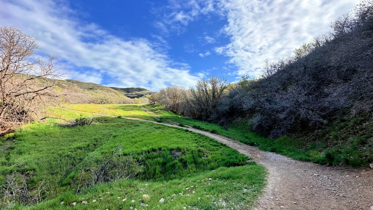![start of valley view loop.jpeg]()](https://images.squarespace-cdn.com/content/v1/5f39599f0dd69335c3379b81/1719007017130-DZIVOUWKOP9ONMHU52IY/start+of+valley+view+loop.jpeg)
[View fullsize ![hiking toward black mountain.jpeg]()](https://images.squarespace-cdn.com/content/v1/5f39599f0dd69335c3379b81/1719007018236-47RFWY2WFI9BCDSZ3VPK/hiking+toward+black+mountain.jpeg)
[View fullsize ![hiking back from black mountain.jpeg]()](https://images.squarespace-cdn.com/content/v1/5f39599f0dd69335c3379b81/1719007016563-HKEOVA765O2ZE8XNSR0G/hiking+back+from+black+mountain.jpeg)
[View fullsize ![parking for valley view.jpeg]()](https://images.squarespace-cdn.com/content/v1/5f39599f0dd69335c3379b81/1719007095686-LPUQHOTPQL6MY1DXI5F8/parking+for+valley+view.jpeg)
Complete the loop, and you’ll find the area buzzing with mountain bikers and happy, off-leash dogs. It seems the leash law here is as loose as the trails are fun\!
For an unforgettable experience filled with nature’s beauty and a dash of whimsy, the Valley View and Twin Peaks Loop Trail is your go-to for hikes in Utah Salt Lake City.
### How to Get There
From the University of Utah, get onto E Federal Heights Drive. Go 3/4 mile, turn left onto N Virginia Street. In about a 1/2 mile, take left onto Chandler Drive. Turn Right onto Cambridge Way, then left onto the 1st cross street onto Perrys Hollow Road N.
**NOTE\!** You are in a fancy neighborhood and it will feel wrong. BUT the trailhead starts at the end of the road, requiring you to park on neighborhood streets.
**ADDRESS:** 1100-1198 E Perrys Hollow Rd, Salt Lake City, UT 84103
### Trail Highs
- Stunning mountain views
- Great Salt Lake City views
### Trail Lows
- Tons of wide and very exposed trail
- Share with bikers
- Trail would be super hot in the summer months \*not a bit of shade
[Back to the Table of Contents](https://www.coloradohikesandhops.com/blog/hiking-salt-lake-city-area#table-of-contents)
## Local Recommended Hikes
### **Donut Falls Trail**
**Mileage: 1.5 miles \| Elevation: 291’**
Donut Falls, just a short drive from Salt Lake City, offers a family-friendly hiking adventure that leads to a unique and mesmerizing waterfall. This popular trail is bustling, especially on Friday mornings, so an early start is recommended.
You'll begin at the Donut Falls Trailhead, trekking along a well-marked path that takes you over a charming wooden bridge and through a steep boulder field, where a bit of scrambling and getting your feet wet is part of the fun. The falls, named for the donut-hole shape in the rock through which water cascades into a cave pool, are well worth the effort.
Be mindful of private property easements along the trail and ensure you stay on the designated path to help maintain public access. If the main trailhead is full or it’s winter, parking at Mill D Trailhead adds an extra mile round-trip.
### **Cecret Lake**
**Mileage: 1.8 miles \| Elevation: 465’**
This gorgeous hike is a short but challenging uphill trek, with rocky terrain near the top, leading to a serene and lovely lake. The trail, which has a \$10 entry fee, is easy to follow but might be challenging for younger children as you get closer to the lake.
Along the way, you'll enjoy crisp, cool air, vibrant flowers, and even spot salamanders in the water. The peaceful atmosphere at the lake makes the effort worthwhile, and encountering the Tiger Salamanders adds an exciting touch to this scenic adventure.
[Back to the Table of Contents](https://www.coloradohikesandhops.com/blog/hiking-salt-lake-city-area#table-of-contents)
View fullsize

Nomad East Pizza
## **COHH HOPS \*Places to Eat and Gear Shop**
### **RESTAURANTS**
- [**Nomad East**](https://airial.travel/restaurants/united-states/salt-lake-city/nomad-east-TNvZLQy_) (1675 E 1300 S, Salt Lake City, UT 84105) **Full disclosure:** we eat here every single time we're in Salt Lake City visiting our son at the U of U. It's become a non-negotiable family stop — and yes, we'll keep coming back long after he graduates.
Situated in a charming neighborhood, this eatery offers both indoor and outdoor seating. The menu features incredible salads, like the smoked salmon salad with raisins, Hungarian paprika cream dressing, radishes, greens, and a sprinkle of paprika-seasoned toasted bread crumbs. *\*Melody’s favorite\!* Their pizzas are equally amazing; we loved the Mushroom with olive tapenade and radicchio, and the Pink Lady with Spam looked great too. Veggie options are plentiful and delightful.
- **Oishi Ramen** (3424 S State Street 84115) \*While ramen might be the new hip thing, we are here for it! Fresh made to order bowls of broth filled with delectable ingredients hit the spot post hike\!
- **Gourmandise** (250 South 300 East 8411) \*Think French bakery meets the west. Amazing pastries, awesome brunch and great coffee\!
- **Franklin Ave Cocktails & Kitchen** (231 S Edison St, Salt Lake City, UT 84111) \*This 21-and-older bar strictly cards at the entrance, in line with UT law for bars serving food, creating a kid-free environment.
The extensive menu includes a wide selection of cocktails (try the tequila martini), a great wine list, and insane food options like sausage-stuffed olives, dill potato chips with whipped feta, a massive fried chicken sandwich, a delectable steak sandwich, and rich, satisfying chocolate pudding for dessert.
- **The DoDo in Sugarhouse** ( 1355 E 2100 S, Salt Lake City, UT 84105) \*Get the turkey sandwich. Even for this sporadic meat eater, this was the move\!
[View fullsize ![tavern olive bite.jpeg]()](https://images.squarespace-cdn.com/content/v1/5f39599f0dd69335c3379b81/1719008479213-GP11S264K0ILWCS23HJJ/tavern+olive+bite.jpeg)
[View fullsize ![franklin ave front door.jpeg]()](https://images.squarespace-cdn.com/content/v1/5f39599f0dd69335c3379b81/1719008480348-4C5BZDBM4E7RTDQY8AI8/franklin+ave+front+door.jpeg)
[View fullsize ![amazing salmon salad.jpeg]()](https://images.squarespace-cdn.com/content/v1/5f39599f0dd69335c3379b81/1719008479267-VYP0OGUH0GROR975OT7F/amazing+salmon+salad.jpeg)
[View fullsize ![gourmandise.jpeg]()](https://images.squarespace-cdn.com/content/v1/5f39599f0dd69335c3379b81/1719008480525-1MZAS19C1DUA93NBP656/gourmandise.jpeg)
[Back to the Table of Contents](https://www.coloradohikesandhops.com/blog/hiking-salt-lake-city-area#table-of-contents)
### **USED GEAR/OUTLETS**
**Gear Room** (3422 Fort Union Blvd, Cottonwood Heights, UT 84121) \*Discounted and well loved, almost new gear is abundant here.
**Moosejaw** (470 S 900 E, Salt Lake City, UT 84102) \*We love this outdoorsy store.
**Patagonia Outlet** ( 2292 Highland Dr., Salt Lake City, UT 84106) \*The deals are hit or miss here. I was able to find a few fleece jackets for well under market price\!
[Back to the Table of Contents](https://www.coloradohikesandhops.com/blog/hiking-salt-lake-city-area#table-of-contents)
[](https://www.jdoqocy.com/click-100379470-11553823?sid=salt+lake+city+hiking&url=https%3A%2F%2Fwww.vrbo.com%2F3670322)
This [beautiful vacation home](https://www.jdoqocy.com/click-100379470-11553823?sid=salt+lake+city+hiking&url=https%3A%2F%2Fwww.vrbo.com%2F3670322) is within minutes of the Sugar House area and the University of Utah campus.
## Where to Stay in Salt Lake City
Because of our university student, we love [staying near the University of Utah](https://=) campus. There are a plethora of vacation rental homes and hotels.
The Sugar House area has a delightful park as well as many restaurants to frequent. We love this [modern home within minutes of campus](https://.), allowing us to walk or take the trolley into downtown Salt Lake City.
Downtown Salt Lake City is worth exploring so consider staying at [this updated apartment](https://www.jdoqocy.com/click-100379470-11553823?sid=salt+lake+city+hiking&url=https%3A%2F%2Fwww.vrbo.com%2F3440787) within walking distance of Temple Square.
[Top Vacation Homes In Salt Lake city](https://www.anrdoezrs.net/click-100379470-11553823?sid=salt+lake+city+hikes&url=https%3A%2F%2Fwww.vrbo.com%2Fvacation-rentals%2Fusa%2Futah%2Fsalt-lake-city)
[Back to the Table of Contents](https://www.coloradohikesandhops.com/blog/hiking-salt-lake-city-area#table-of-contents)
View fullsize

## What to Wear While Hiking Salt Lake City Area
Like Colorado, Utah experiences a variety of seasons within just a few hours. The biggest difference between hiking in Colorado and Utah is the heat and altitude. Summer hiking in the Salt Lake City area is downright HOT, while spring hiking can range from freezing temps in the morning to lovely breezy moments by midday.
Another perk is that the altitude in Utah is lower than in places like Colorado Springs, making the hikes a bit easier on the lungs. You can enjoy the stunning views without feeling as winded\!
**Here’s a few extra things to your Salt Lake City hiking daypack\!**
- [Cooling Towel](https://amzn.to/4379BuF) \*A must for hiking Salt Lake trails in summer months
- [Gaiters](https://rei.pxf.io/BnR9vq) \*Trails can be filled with tiny pebbles that get into your shoes.
I took my Colorado Capsule Wardrobe to the Salt Lake trails and found that most of my layering worked great.
[What to Wear Hiking Trails](https://www.coloradohikesandhops.com/blog/what-to-wear-hiking-in-colorado)
## **Must Have Gear for Hiking Salt Lake City Area in 2026**
We love the [Osprey Sirrus Hiking Daypack](https://rei.pxf.io/POm6rM) for women, or the [Osprey Stratos version for men](https://rei.pxf.io/aOrWxq), for carrying water, layers, and snacks on Colorado day hikes
- [Free Fly’s High Mile Jogger](https://freeflyapparel.sjv.io/k05djz) is the perfect hiking pant! Comfy, stylish and durable\!
- Lightweight, [versatile Hiking Poles](https://www.rei.com/search?q=hiking+poles+black+diamond) built for a full day’s send on the trail — hike longer and stronger
- 2L or 3L Water Reservoir — This [affordable reservoir](https://rei.pxf.io/dO5773) is easy to fill
- Patagonia Torrentshell - a true [waterproof rain jacket](https://www.rei.com/search?q=patagonia++torrentshell) and fantastic layering piece
- [Nano Puff Jacket](https://rei.pxf.io/POm66M) \- our favorite for 3 seasons in Colorado
- Smartwool Glove Liners - the [best all season gloves](https://rei.pxf.io/19ZWW6) for those high altitude hikes
- [Salomon hiking shoes](https://rei.pxf.io/gOaWWv) - waterproof, comfy and hard working for any type of hike
[Back to the Table of Contents](https://www.coloradohikesandhops.com/blog/hiking-salt-lake-city-area#table-of-contents)
View fullsize
Hiking the trails in the Salt Lake City area has become one of my new favorite hobbies. While Coloradans joke about Utah residents coming over to climb their mountains, we've been missing out by not heading the other direction. With stunning low-altitude hikes and easy access to city trails, the best hikes in Salt Lake City are just minutes from the main streets.
### Let us know your favorite Salt Lake City area hikes\!
We can’t wait to try more\!
[Back to the Table of Contents](https://www.coloradohikesandhops.com/blog/hiking-salt-lake-city-area#table-of-contents)
[Melodie Monberg](https://www.coloradohikesandhops.com/blog?author=5f401ef137a898211f50fa4b)
November 21, 2025
[Facebook0](https://www.facebook.com/sharer/sharer.php?u=https%3A%2F%2Fwww.coloradohikesandhops.com%2Fblog%2Fhiking-salt-lake-city-area)
[Twitter](https://twitter.com/intent/tweet?url=https%3A%2F%2Fwww.coloradohikesandhops.com%2Fblog%2Fhiking-salt-lake-city-area&text=The+best+hikes+in+Salt+Lake+City+are+just+20+minutes+from+downtown%2C+offering+year-round+joy%21+With+...)
[LinkedIn0](https://www.linkedin.com/shareArticle?mini=true&source=Colorado+Hikes+and+Hops&summary=The+best+hikes+in+Salt+Lake+City+are+just+20+minutes+from+downtown%2C+offering+year-round+joy%21+With+...&url=https%3A%2F%2Fwww.coloradohikesandhops.com%2Fblog%2Fhiking-salt-lake-city-area)
[Reddit](https://www.reddit.com/submit?url=https%3A%2F%2Fwww.coloradohikesandhops.com%2Fblog%2Fhiking-salt-lake-city-area)
[Pinterest0](https://www.pinterest.com/pin/create/link/?description=The+best+hikes+in+Salt+Lake+City+are+just+20+minutes+from+downtown%2C+offering+year-round+joy%21+With+...&media=https://images.squarespace-cdn.com/content/v1/5f39599f0dd69335c3379b81/1718971945457-TMQP66YSTB6YTBYO39P8/bells+canyon+falls+cover+shot.jpeg&url=https%3A%2F%2Fwww.coloradohikesandhops.com%2Fblog%2Fhiking-salt-lake-city-area)
[0 Likes](https://www.coloradohikesandhops.com/blog/hiking-salt-lake-city-area)
[Previous 2026 Guide to See Colorado's Best Aspens Fall Colors Melodie Monberg November 21, 2025](https://www.coloradohikesandhops.com/blog/best-colorado-destinations-to-see-aspens-fall-colors-hikes-and-drives)
[Next Southern Colorado Road Trip 2026 colorado road tripsTanya Raedeke November 18, 2025](https://www.coloradohikesandhops.com/blog/southern-colorado-road-trip)
*Colorado Hikes and Hops participates in the Amazon Service LLC Associates Program, an affiliate advertising program designed to provide a means for sites to earn advertising fees by advertising and linking to* [*amazon.com*](https://www.amazon.com/?language=en_US&linkCode=ll2&linkId=18dcb8dce8d7192f6183c11b41afc207&ref_=as_li_ss_tl&tag=coloradohikes-20)*. Our site contains other affiliate links from which we make a small commission, but at no extra cost to you. Thank you for supporting this small women-owned business.*
### More Info:
Unauthorized use and/or duplication of this material without express and written permission from this blog’s author and/or owner is strictly prohibited. Excerpts and links may be used, provided that full and clear credit is given to Colorado Hikes and Hops, LLC, with appropriate and specific direction to the original content.
All adventure trip photos are property of Colorado Hikes and Hops, LLC, unless otherwise noted or tagged. If you would like to link to our images and properly give credit, please email us at [cheers@coloradohikesandhops.com](mailto:cheers@coloradohikesandhops.com?subject=Permission%20to%20use%20a%20photo%20or%20content) to ask permission and to follow our guidelines.
Colorado Hikes and Hops
80920
[cheers@coloradohikesandhops.com](mailto:cheers@coloradohikesandhops.com "cheers@coloradohikesandhops.com")
[Disclosure](https://www.coloradohikesandhops.com/disclosure)[Contact Us](https://www.coloradohikesandhops.com/contact)[Powered by Squarespace](http://www.squarespace.com/) |
| Readable Markdown | *This page contains affiliate links. If you make a purchase via a link on this page, we make a small commission at absolutely no extra charge to you. Thank you for your support of this small women-led business.*
My kid goes to U of Utah so I've been hiking Salt Lake City like crazy—turns out we Coloradans have been missing out because these trails are STUNNING, low altitude, and literally 20 minutes from downtown\!

## From Downtown to Peaks: Hiking Salt Lake City Area
Some of the best hikes in Salt Lake City are just 20 minutes from downtown, and we're sharing our favorite trails—from waterfall hikes to summit scrambles with killer views. Plus, you'll love the lower altitude compared to Colorado and we've got insider tips on parking and timing.
Some of the best hikes in Salt Lake City are within just 20 minutes of downtown. With a child attending the University, I’ve been delighted to explore this mecca of rock formations and gorgeous landscapes.
No matter the season—summer, fall, winter, or spring—hiking the Salt Lake City area is simply delightful. If you know me, I love throwing back a cold brew post hike. While the liquor laws might be a bit quirky, I gladly embrace Utah's nuances to keep enjoying its trails.
Hiking around Salt Lake City is a breeze (All Trails is my BFF), with well-marked trailheads and, most importantly, a sense of safety for solo hikers like myself.
Just like Colorado boasts countless beautiful trails, Salt Lake City offers a charming mix of forests, hills, and scenic views with the added perk of low altitude\!
### **Below are my five standout Salt Lake hikes**.
Included are some great bars (you'll need to show your ID, as only those 21 and older can partake) and amazing outdoor gear outlets like Patagonia.
## Salt Lake City Hiking - Sharing the Trail
**DOGS, BIKES AND HIKERS\!** On many Utah trails, there's an "implied law" about bikes, dogs, and hikers. Off-leash dogs are allowed on odd-numbered days, and dogs must be on a leash on even-numbered days. This even/odd strategy was introduced around 2001 due to the rising number of biker/off-leash dog interactions.
The tension had been building for years because of user conflicts and increased bike traffic.
It’s a quirky system, but it keeps the peace hiking around Salt Lake City\!
Table of Contents[Pipeline Overlook](https://www.coloradohikesandhops.com/blog/hiking-salt-lake-city-area#pipeline)[Grandeur Peak East Trail](https://www.coloradohikesandhops.com/blog/hiking-salt-lake-city-area#grandeur)[Living Room Loop](https://www.coloradohikesandhops.com/blog/hiking-salt-lake-city-area#living)[Lower Falls](https://www.coloradohikesandhops.com/blog/hiking-salt-lake-city-area#falls) Via Bells Canyon Trail[Mount Van Cott via](https://www.coloradohikesandhops.com/blog/hiking-salt-lake-city-area#vancott) Red Butte Canyon Trail Loop[Valley View](https://www.coloradohikesandhops.com/blog/hiking-salt-lake-city-area#valley) and Twin Peaks Loop Trail[Locals Only Trail Recs](https://www.coloradohikesandhops.com/blog/hiking-salt-lake-city-area#locals)[Places to Eat](https://www.coloradohikesandhops.com/blog/hiking-salt-lake-city-area#eat)[Gear Outlets](https://www.coloradohikesandhops.com/blog/hiking-salt-lake-city-area#gear)[Where to Stay](https://www.coloradohikesandhops.com/blog/hiking-salt-lake-city-area#stay)[What to Wear](https://www.coloradohikesandhops.com/blog/hiking-salt-lake-city-area#wear)

Pipeline Overlook
## **Pipeline Overlook via Rattlesnake Gulch**
### **Mileage: 3.9 miles**
### **Elevation: 823’**
Ranked as a moderate hike, Pipeline Trail seems to go on forever. A friend from Utah says the Pipeline Trail is one of the best hikes in Salt Lake City for this reason. This particular section is especially gorgeous with its mountain vista views at the Gulch.
The night we hiked this trail, we caught glimpses of parasailers diving off the cliffs above us. While that sport has never been on my bucket list, if you’re into adventure, this appears to be the place for it\!
**NOTE\!** As you enter the park, you’ll need to pay a \$5 fee, at least on the weekends. When I went back during the week, I didn’t see anyone taking fees or any place to put money.
Pipeline Overlook Trail has a large parking lot, probably holding 30 cars, along with two well-kept and clean vault toilets. On a weekend around 4 p.m., the lot was full but not overwhelming. We easily got a spot and started up on the well-marked trail.
There are so many trails to explore in this area. In fact, I came back later that week to check out more side trails and spur trails.
We loved arriving a bit later in the day, putting on layers for the fast-cooling air. Hiking the Salt Lake City area in early May, the trail was relatively dry with spots of mud along the way.
Keep in mind the first 1 ½ miles are a steep and steady uphill. We hardly noticed the incline because of the low altitude and beauty along the way.
I loved the trees covering the trail, with spring just starting to bud all around us as we hiked. I can only imagine how beautiful hiking Salt Lake trails are in summer and fall.
I highly recommend you take the trail toward Pipeline Lookout. Along with mountain views, you get some stellar shots of downtown Salt Lake City and the University of Utah.
### How To Get There:
Depending on where you stay, directions vary. Hop on I-215/Belt South, taking exit 4 toward Hospital. Left onto 3900 S. Left on Wasatch Blvd. Follow Mill Creek Canyon Rd to Forest Road 269.
**ADDRESS:** Forest Rd 269, Salt Lake City, UT 84124
### TRAIL HIGHS
- Insane mountain views
- Well marked trail, often wide enough for two to hike side by side
- Shady in spots
### TRAIL LOWS
- Obvious muddy spots (Spring hiking!) and rutted trail due to mud drying
- Fee to pay to use area
### My \#1 SOLO HIKING TIP\!
Hiking alone has become one of my favorite ways to disconnect from the outside world. If you’ve wondered how safe it is to hike solo, I’ve been in your shoes! In fact, over the past few years, hiking alone has become the main way I explore new trails and places.
I’ve learned a few things on my journey, [pro tips I wish I’d known ahead of time](https://www.coloradohikesandhops.com/blog/hiking-alone).
A favorite tool in my arsenal of solo hiking and backpacking is the Garmin inReach Mini. For around \$400 new (or on sale/preowned for \$300 or less), this small device keeps me connected to the outside world. My husband can find me on the trails with its map-sharing feature.
I send messages to him on my hikes and trips, staying in contact in case of emergency.
The Garmin inReach Mini gives the solo hiker the freedom to explore while staying safe\!
Stopping to take in the views along Granduar Peak
## **Grandeur Peak East Trail**
### **Mileage: 5.6 miles**
### **Elevation: 2352’**
Armed with 2 liters of water, snacks, a hat, gloves, and my trusty Garmin inReach Mini, I set out on hikes in Utah Salt Lake City on my own. After checking the weather report and trail conditions (snow was still a big deal on many trails in early May in Utah), I headed toward Pipeline Trail.
I arrived at the trailhead around 8:30 a.m. There's no dedicated parking area, so you have to park on the road. With two routes to the trailhead, I chose walking through a well-established picnic area with lots of signs saying, “no parking for hikers, picnickers only.”
This little detour is stunning, with water gushing down falls along the road. The paved road is an option but honestly, pick the dirt path, it’s far prettier.
Both paths lead to the large trailhead sign\!
You can't miss the trailhead sign—it's a big wooden marker that starts the ascent.
Keep to the left as you hike.
This is one hike where the pictures tell the story better than words. On an early spring day, hiking around Salt Lake City felt like a dream. I passed only a handful of people during the 2 1/2 hours I was on the trail. BLISS for this introvert\!
At mile 1, take the wooden steps that run alongside the waterfalls. In early May, spring was just starting, with tons of shade for summer and fall. It was a cloudy day when I went, and I loved the large trees and rushing water along the way.
Hiking to Grandeur Peak
There are a few intense uphill sections, but just as it started to get tough, the trail levels out.
Expect a rather padded, “loamy” trail for the first bit. I loved the squishy bits of plants under my feet as I hiked. The trail transitions to dirt and then to rocks—big and small.
Hiking shoes are a must for this trail. Several trail runners passed me wearing sturdy trail shoes as well.
[**I wished I’d had my hiking poles**](https://www.coloradohikesandhops.com/gear-reviews/best-hiking-poles) for the last bit when I was sliding and sloshing through melted snow.
**PRO TIP\!** Unsure whether to wear hiking shoes, trail runners, or boots for Salt Lake City area hikes? We've got you covered. Learn how to [find and fit the best hiking shoes](https://www.coloradohikesandhops.com/blog/how-to-choose-hiking-boots-shoes-trail-runners) for your needs\!
The last mile to the summit is pretty challenging and steep. Keep to the left along the trail; it’s a well-worn path that's clearly marked. When I went in May, there was about a 100-foot section of very slippery snow. Coming down, I ended up on my butt for most of it.
This section was a bit unnerving, as the cliffs on either side are very steep.
### How to get there
Depending on where you stay in Salt Lake City, directions vary. Hop on I-215/Belt South, taking exit 4 toward Hospital. Left onto 3900 S. Left on Wasatch Blvd. Follow Mill Creek Canyon Rd to S Church Fork.
**ADDRESS:** Millcreek, Utah 84109
### Trail Highs
- Plenty of parking
- Well marked trail signs
- Spectacular Views
- Shaded areas (for summer hiking)
### Trail Lows
- Fee to enter \*it appears to be weekends only
- Muddy in spring \*rutted path due to shared bike trail
Salt Lake City views from the Living Room at dawn
## **Living Room Loop**
### **Mileage: 2.3 miles**
### **Elevation: 977’**
As one of the most popular Salt Lake City Utah hiking areas due to its short distance and superb location near the University of Utah, the Living Room Loop is not to be mistaken for an easy hike.
It’s a great early morning or late sunset hike. Avoid the middle of the day, as the area is very exposed and heats up fast.
Grab your hiking shoes and leave the sandals at home. This hike is akin to the [Manitou Incline in Colorado](https://www.coloradohikesandhops.com/blog/the-manitou-incline). It’s a steep trail with tons of rocky terrain. Head up the well-marked path after parking along the road by the Natural History Museum near the University of Utah.
Three-hour parking is free.
**NOTE\!** The Natural History Museum is worth the entrance fee! Consider stopping here post hike to brush up on earth science. Even if you’re not a history buff, the exhibits are dynamic and interesting. U of U students get in for free.
Start climbing up and then loop to the left along a switchback of sorts. Hike a bit (maybe ¼ mile) to a dirt road. Turn right and look for a wide gravel trail headed to the left. \*See picture above.
Once on this trail, keep right as you work up the canyon. Going left will take you on splinter trails and not to the Living Room.
The final push is a hill. As the trail makes a significant turn to the left, your intense climbing is over. You’ll know you’ve arrived at the Living Room when you see the many rock formations placed as “stools” up there.
**NOTE\!** This is one hike where you should leave the headphones at home. There are runners racing down while others are huffing up. You’ll want to make sure to step aside as hiking etiquette dictates.
Hiking in the Salt Lake City area is not complete without visiting the Living Room.
We often tack on this hike as a great post-supper sunset viewing experience.
### HOW TO GET THERE
From the University of Utah, head northwest on Foothills Drive. Turn right onto Wakara Way. Turn right onto S 2310 E/S Colorow Drive.
**ADDRESS:** S Colorow Dr, Salt Lake City, UT 84108
### Trail Highs
- Easy to access near University of Utah
- Well marked trail
- Short distance, solid hike
### Trail Lows
- Very steep in areas
- Very popular hike
- No shade

Lower Falls
**Lower Falls Via Bells Canyon Trail****Mileage: 4.8 miles****Elevation: 1515’**

HIke toward the reservoir on the Bells Canyon Trail
A 20 minute ride from most parts of downtown, this is a must do Salt Lake area hike.
Lower Falls via Bells Canyon Trail one of my favorite hikes in Salt Lake City. I started around 8:30 am, with just a few cars in the lot and a peaceful trail ahead. The hike begins with gentle switchbacks, offering stunning mountain and city views.
Many families hike to the watershed a bit up the trail. It’s the perfect place to stop and let kids wander freely on the trail. You can fish but not dip in this body of water.
Bells Canyon trail is a relatively easy trek until the final mile to the waterfall, where the trail becomes rocky and you might encounter a 100-yard stretch of melting snow and ice, especially in late April/early May.
The route to the lower falls is somewhat marked and veers to the left, leading to a spectacular view of water cascading like crazy—simply gorgeous.
\*Download the All Trails map before heading out. It will be helpful as you navigate the area around the falls. I attempted to head up to the upper falls but had to turn around due to solid ice and no spikes.
**PRO TIP:** Always carry extra gear for spring hikes. I could have summited the Upper Falls with [my Kahtoola spikes](https://www.coloradohikesandhops.com/gear-reviews/micro-spikes-on-colorado-trails). Next time\!
This 5-mile hike is a great mix of moderate terrain with a touch of difficulty on the final ascent. It's perfect for anyone who loves a bit of adventure.
On the way down, you'll likely pass families with little kids enjoying the hiking Salt Lake City area reservoir.
### HOW TO GET THERE
Take I-215 S/Belt Route to exit 6 for 6200 S. Take 6200 S to Wasatch Blvd E, turning right onto Wasatch Blvd. Turn left onto UT -209 E. Turn right at Trailhead.
**ADDRESS:** Bell Canyon Trail, Sandy, UT 84092
### Trail Highs
- Large parking lot
- Gorgeous waterfalls
- Moderate trail
### Trail Lows
- Snow covers upper trail \*hard to find
- Congested with people by reservoir
Salt Lake City hiking at its best along the Red Butte Canyon Trail
## **Mount Van Cott via Red Butte Canyon Trail Loop**
### **Mileage: 4.5 miles**
### **Elevation: 1710’**
If you’re searching for epic hikes in Utah Salt Lake City, Mount Van Cott is a hidden gem just north of the University of Utah. Park your car along the road by the Natural History Museum, where you’ll find 3-hour parking (and yes, they do check, so don’t dawdle!).
Starting your adventure, the first half-mile presents a delightful challenge with hilly terrain that’s sure to give your legs a satisfying workout.
This hike is no stroll in the park; it’s a bona fide ball-buster that will have you breaking a sweat in no time, thanks to its completely exposed trail. But fear not, the counter-clockwise route is your secret weapon – it’s a gift that keeps on giving.
While the descent is steep and wild, tackling it first means you conquer the hard part right away, leaving the rest of the hike to be enjoyed at a more leisurely pace.
You’ll find yourself in serene solitude, having passed very few fellow adventurers along the way. The peace and quiet are perfect for soaking in the natural beauty and the stunning views that Salt Lake City hikes are known for.
Don’t expect to be glued to your phone, though; cell service lingers at just one bar the entire time, making this the perfect opportunity to unplug and immerse yourself in the wilderness.
Whether you’re a seasoned hiker looking for your next challenge or a curious explorer ready to discover the best hikes in Utah Salt Lake City, this trail offers an unforgettable adventure filled with whimsy and wonder.
### How to Get There
From the University of Utah, head northwest on Foothills Drive. Turn right onto Wakara Way. About 3/4 mile down the road, turn right onto S 231 E/S Colorow Drive.
**ADDRESS:** S Colorow Drive, Salt Lake City, UT
### Trail Highs
- In middle of city but feels like the country
- Stunning views of Downtown Salt Lake City from the summit
### Trail Lows
- Very exposed hike \*no shade
- Super muddy after a rain \*hiking shoes really help

Valley Views
**Valley View and Twin Peaks Loop Trail****Mileage: 6.93 miles**Elevation: 1804’

Whimsical tree at the start of the trail
Get ready for a whimsical journey on the Valley View and Twin Peaks Loop Trail in Salt Lake City\!
Start your adventure by parking in a picturesque neighborhood (just remember, no parking between 10 pm and 6 am).
As you set off on this loop hike, take the counter-clockwise route to the left and brace yourself for a steep first mile. The climb is a leg-burner, but the solitude—seeing very few hikers this direction—makes it all worth it.
Forge ahead and explore the myriad of social trails crisscrossing the area. When you reach the majestic Twin Peaks, the views will leave you breathless.
If you're feeling adventurous, continue toward Black Mountain, its summit puts you at 8,150’.
However, the dense forest and icy patches may prompt you to turn back about a quarter mile from the summit—especially without microspikes or poles. \*When I hiked this early May, I had forgotten all my winter gear so had to turn around.
Despite the challenging terrain, you’ll have cell reception throughout the hike, so you can snap and share those epic views.
Complete the loop, and you’ll find the area buzzing with mountain bikers and happy, off-leash dogs. It seems the leash law here is as loose as the trails are fun\!
For an unforgettable experience filled with nature’s beauty and a dash of whimsy, the Valley View and Twin Peaks Loop Trail is your go-to for hikes in Utah Salt Lake City.
### How to Get There
From the University of Utah, get onto E Federal Heights Drive. Go 3/4 mile, turn left onto N Virginia Street. In about a 1/2 mile, take left onto Chandler Drive. Turn Right onto Cambridge Way, then left onto the 1st cross street onto Perrys Hollow Road N.
**NOTE\!** You are in a fancy neighborhood and it will feel wrong. BUT the trailhead starts at the end of the road, requiring you to park on neighborhood streets.
**ADDRESS:** 1100-1198 E Perrys Hollow Rd, Salt Lake City, UT 84103
### Trail Highs
- Stunning mountain views
- Great Salt Lake City views
### Trail Lows
- Tons of wide and very exposed trail
- Share with bikers
- Trail would be super hot in the summer months \*not a bit of shade

## Local Recommended Hikes
### **Donut Falls Trail**
**Mileage: 1.5 miles \| Elevation: 291’**
Donut Falls, just a short drive from Salt Lake City, offers a family-friendly hiking adventure that leads to a unique and mesmerizing waterfall. This popular trail is bustling, especially on Friday mornings, so an early start is recommended.
You'll begin at the Donut Falls Trailhead, trekking along a well-marked path that takes you over a charming wooden bridge and through a steep boulder field, where a bit of scrambling and getting your feet wet is part of the fun. The falls, named for the donut-hole shape in the rock through which water cascades into a cave pool, are well worth the effort.
Be mindful of private property easements along the trail and ensure you stay on the designated path to help maintain public access. If the main trailhead is full or it’s winter, parking at Mill D Trailhead adds an extra mile round-trip.
### **Cecret Lake**
**Mileage: 1.8 miles \| Elevation: 465’**
This gorgeous hike is a short but challenging uphill trek, with rocky terrain near the top, leading to a serene and lovely lake. The trail, which has a \$10 entry fee, is easy to follow but might be challenging for younger children as you get closer to the lake.
Along the way, you'll enjoy crisp, cool air, vibrant flowers, and even spot salamanders in the water. The peaceful atmosphere at the lake makes the effort worthwhile, and encountering the Tiger Salamanders adds an exciting touch to this scenic adventure.
Nomad East Pizza
## **COHH HOPS \*Places to Eat and Gear Shop**
### **RESTAURANTS**
- [**Nomad East**](https://airial.travel/restaurants/united-states/salt-lake-city/nomad-east-TNvZLQy_) (1675 E 1300 S, Salt Lake City, UT 84105) **Full disclosure:** we eat here every single time we're in Salt Lake City visiting our son at the U of U. It's become a non-negotiable family stop — and yes, we'll keep coming back long after he graduates.
Situated in a charming neighborhood, this eatery offers both indoor and outdoor seating. The menu features incredible salads, like the smoked salmon salad with raisins, Hungarian paprika cream dressing, radishes, greens, and a sprinkle of paprika-seasoned toasted bread crumbs. *\*Melody’s favorite\!* Their pizzas are equally amazing; we loved the Mushroom with olive tapenade and radicchio, and the Pink Lady with Spam looked great too. Veggie options are plentiful and delightful.
- **Oishi Ramen** (3424 S State Street 84115) \*While ramen might be the new hip thing, we are here for it! Fresh made to order bowls of broth filled with delectable ingredients hit the spot post hike\!
- **Gourmandise** (250 South 300 East 8411) \*Think French bakery meets the west. Amazing pastries, awesome brunch and great coffee\!
- **Franklin Ave Cocktails & Kitchen** (231 S Edison St, Salt Lake City, UT 84111) \*This 21-and-older bar strictly cards at the entrance, in line with UT law for bars serving food, creating a kid-free environment.
The extensive menu includes a wide selection of cocktails (try the tequila martini), a great wine list, and insane food options like sausage-stuffed olives, dill potato chips with whipped feta, a massive fried chicken sandwich, a delectable steak sandwich, and rich, satisfying chocolate pudding for dessert.
- **The DoDo in Sugarhouse** ( 1355 E 2100 S, Salt Lake City, UT 84105) \*Get the turkey sandwich. Even for this sporadic meat eater, this was the move\!
### **USED GEAR/OUTLETS**
**Gear Room** (3422 Fort Union Blvd, Cottonwood Heights, UT 84121) \*Discounted and well loved, almost new gear is abundant here.
**Moosejaw** (470 S 900 E, Salt Lake City, UT 84102) \*We love this outdoorsy store.
**Patagonia Outlet** ( 2292 Highland Dr., Salt Lake City, UT 84106) \*The deals are hit or miss here. I was able to find a few fleece jackets for well under market price\!
## Where to Stay in Salt Lake City
Because of our university student, we love [staying near the University of Utah](https://=) campus. There are a plethora of vacation rental homes and hotels.
The Sugar House area has a delightful park as well as many restaurants to frequent. We love this [modern home within minutes of campus](https://.), allowing us to walk or take the trolley into downtown Salt Lake City.
Downtown Salt Lake City is worth exploring so consider staying at [this updated apartment](https://www.jdoqocy.com/click-100379470-11553823?sid=salt+lake+city+hiking&url=https%3A%2F%2Fwww.vrbo.com%2F3440787) within walking distance of Temple Square.
## What to Wear While Hiking Salt Lake City Area
Like Colorado, Utah experiences a variety of seasons within just a few hours. The biggest difference between hiking in Colorado and Utah is the heat and altitude. Summer hiking in the Salt Lake City area is downright HOT, while spring hiking can range from freezing temps in the morning to lovely breezy moments by midday.
Another perk is that the altitude in Utah is lower than in places like Colorado Springs, making the hikes a bit easier on the lungs. You can enjoy the stunning views without feeling as winded\!
**Here’s a few extra things to your Salt Lake City hiking daypack\!**
- [Cooling Towel](https://amzn.to/4379BuF) \*A must for hiking Salt Lake trails in summer months
- [Gaiters](https://rei.pxf.io/BnR9vq) \*Trails can be filled with tiny pebbles that get into your shoes.
I took my Colorado Capsule Wardrobe to the Salt Lake trails and found that most of my layering worked great.
Hiking the trails in the Salt Lake City area has become one of my new favorite hobbies. While Coloradans joke about Utah residents coming over to climb their mountains, we've been missing out by not heading the other direction. With stunning low-altitude hikes and easy access to city trails, the best hikes in Salt Lake City are just minutes from the main streets.
### Let us know your favorite Salt Lake City area hikes\!
We can’t wait to try more\!
November 21, 2025 |
| Shard | 108 (laksa) |
| Root Hash | 8918371663933831508 |
| Unparsed URL | com,coloradohikesandhops!www,/blog/hiking-salt-lake-city-area s443 |