ℹ️ Skipped - page is already crawled
| Filter | Status | Condition | Details |
|---|---|---|---|
| HTTP status | PASS | download_http_code = 200 | HTTP 200 |
| Age cutoff | PASS | download_stamp > now() - 6 MONTH | 1 months ago |
| History drop | PASS | isNull(history_drop_reason) | No drop reason |
| Spam/ban | PASS | fh_dont_index != 1 AND ml_spam_score = 0 | ml_spam_score=0 |
| Canonical | PASS | meta_canonical IS NULL OR = '' OR = src_unparsed | Not set |
| Property | Value |
|---|---|
| URL | https://www.andbluesky.com/branson-hiking-trails/ |
| Last Crawled | 2026-03-14 12:56:49 (1 month ago) |
| First Indexed | 2022-03-27 15:17:12 (4 years ago) |
| HTTP Status Code | 200 |
| Meta Title | A Complete Guide to Branson Hiking Trails - ...and Blue Sky |
| Meta Description | Your complete guide to the Branson hiking trails complete with maps, route suggestions, and info on on-site facilities. |
| Meta Canonical | null |
| Boilerpipe Text | There are countless
outdoor activities in Branson, MO
and the surrounding area, but the
Branson hiking trails
are by far my favorites. Whether you are visiting Branson and want to enjoy the natural beauty of the area or you’re a Branson local looking for something fun to do on your day off, I hope this
Branson hiking trail guide
is helpful for you!
***This is very much a work in progress and still has missing info but I wanted to go ahead and publish the info I have ready for people planning trips to Branson soon!**
Want to skip straight to the list of trails?
Click here!
I noticed something when I was searching for a
list of Branson hiking trails
recently: every list I came across was either seriously lacking in detail or compiled by someone who had clearly never actually done any of the trails. I also found guides that would just describe a trail as “moderate” or “easy” very frustrating. Easy for who? Give me details!
So I wanted to put together a guide to Branson hiking trails that’s actually helpful.
I’ve tried to include everything I can think of to help you know what to expect.
Is this a trail you can bring small kids on, or is it better for experienced hikers? Do you need waterproof shoes to cross creeks and make your way through mud? If there are multiple trails at one location, what’s the best one if you have one hour and want the best experience?
I’ve almost hiked every trail on this list multiple times
, usually 10+ times. For the few exceptions that I haven’t gotten to yet, I did extensive searching to pull together as much information as possible for you and will continue to update this page as I get the chance to explore them in person.
To keep things organized and easy, I’ve included the following info for each of the Branson hiking trails:
💭
Summary
: The trail summed up in a few words so that you can quickly decide if you want to learn more.
🌿
Number of trails
: Many locations have just one trail, but others have several to choose from.
⏲️ Estimated Time
: A ballpark figure of how long to allow if you’re walking a trail at a moderate pace and perhaps stopping to take a few photos. My goal is to at least give you an idea if you should plan on 20 minutes or two hours.
🚴
Bikes?
I’m not a mountain biker (yet!) but a lot of these trails are popular with people who are, and a couple are great for regular bikes, too.
🐕
Dog Friendly Hiking Trails in Branson
: If a trail has any signs about whether four-legged friends are welcome or not, I’ll include that, plus whether or not they have bags to clean up after them or any other relevant info. (Side note: If you go hiking with an adventure cat, I totally want to see photos!)
🔰
Difficulty Level
: It’s hard to give objective difficulty ratings; one person’s walk in the park is another person’s Mt. Everest. Since our definitions of the “average person” might be quite different from each other, I’m basing my ratings on someone who is at a fitness level where you’re comfortable walking for an hour but not a serious athlete. I try to include info for those with mobility disabilities, because the outdoors are for everyone. I’ll be using the following 1-5 rating system to help you decide if a trail is right for you:
1 – A casual stroll.
This trail is suitable for almost anyone, including small children and those with limited fitness levels. Perfect for a long chat with your walking buddy while enjoying the scenery.
2 – A fairly easy trail.
This may be a bit longer or rougher than a level 1 trail, or offer some sort of obstacle like crossing a stream that may somewhat limit who can navigate it. You might need to be able to step over large rocks or walk up and down some moderate hills, but otherwise it’s just a nice walk in the woods.
3- A moderate trail.
This trail might be a bit of a workout, but still suitable for our “average” person described above.
4- Moderately difficult
– A physically challenging trail, either in terms of length, rugged terrain, or other factors.
5- Difficult
– A serious challenge. To be honest, it’s unlikely you’ll see me reviewing any of these. I’m a writer who spends most of my time in front of a laptop! If you’d like to review difficult Branson hiking trails (if we even have any here?) for this site, though, let me know!
🌿
Terrain
makes a big difference! A half mile long trail that’s rocky and steep can be ten times more exhausting than a two mile long flat, paved trail, in my experience.
Paved
: I’ll note if these are suitable for strollers and wheelchairs.
Smooth
: Not paved, but a mostly flat surface. This may include trails with gravel or wood chip footing, or dirt trails that are not very rocky. You can probably do these in whatever comfortable shoes you happened to pack.
Natural
: A natural dirt or grassy trail. May be a bit hilly or rocky (skip the flip-flops for these!), but not especially rugged.
Rough
: Expect steep hills, rocky footing, or otherwise uneven footing that is going to require your attention.
📸
Points of Interest
: Is there a scenic overlook point, an old cabin, a cool waterfall, or something else to see along the way?
🚻
Facilities
: Are there restrooms, water fountains, or sinks available near the trail? If so, they will be listed here.
❇️
Also On Site:
Playgrounds, gift shops, attractions, and anything else you might find at the same location.
🧭
Where to Find It:
How to get to the trail. I’ve provided an address you can use in your GPS or Maps app if possible, otherwise nearby streets and landmarks are given. Parking is also noted here.
🗺️
Trail Map:
If a map of the trail is available online, you will find a link here.
🌿
Review
: If I have blogged about the trail, you will find a link to the post about my experience. Check these out for more in depth info about each route as well as plenty of photos, suggested routes, the closest place to find a bottle of water or a restroom if there are none on-site, suggested footwear, and my personal tips on how to best enjoy each trail.
Note: For some reason my table of contents links take you to a couple of lines below where each one actually starts, so if you use them to navigate just scroll up a bit to get to the actual beginning of each trail. If anyone is a HTML wizard and knows how to fix this, please share!
Branson Hiking Trails Table of Contents:
Branson Waterfall Trail
Lakeside Forest Wilderness Area Trails
Roark Creek Trail
Table Rock Lakeshore Trail
Henning Conservation Area
White River Valley Trail System
Boston Ferry Trail
Shepherd of the Hills Fish Hatchery Trails
Chinquapin Trail at Table Rock State Park
Branson Boardwalk Trail
If you know of any Branson hiking trails I’ve left out, please let me know!
Branson Waterfall Trail
💭 Summary: A short trail that crosses Roark Creek and leads to a small waterfall.
🌿Number of trails: 1
📏Trail Length: About 1.4 miles out and back
⏲️Estimated Time: 45 minutes
🚴 Bikes are not allowed on this trail.
🐕: Leashed dogs are welcome
🔰 Difficulty Level: 2.5
🌿Terrain: Natural & Rough. Expect some small steep hills, a few shallow streams to ford, and occasional slippery mud.
📸 Points of Interest: The trail ends at a small waterfall.
🚻 Facilities: There are no restrooms on-site.
❇️ Also On Site: N/A, just the trail.
🧭 Where to Find It: The Branson Waterfall Trail runs behind
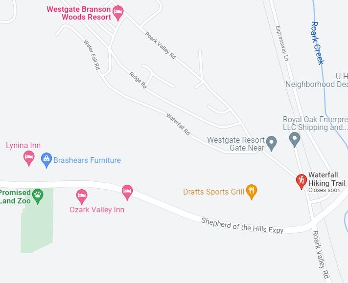
Westgate Branson Woods Resort
, which is located on Roark Valley Road near where it intersects with Shepherd of the Hills Expressway. Trail parking is available across the street from the resort near the Charcoal Factory. You can use the following address for directions: 1902 Roark Valley Rd, Branson, MO 65616
🗺️ Trail Map:
City of Branson Waterfall Trail Map
🌿 Branson Waterfall Trail Review Coming Soon
Branson Lakeside Forest Wilderness Area Trails
💭 Summary: Just off the 76-strip, these trails wind through a historic homestead and offer some great lake views.
Note
: This trail system has an interactive trail map that you can scan a QR code for, but I haven’t tried this out yet. I’ll update when I do!
🌿Number of trails: Technically, there are 5: the red, yellow, green, blue, and purple. However, these all connect with each other at multiple points, so you can easily combine pieces of each one to make your own route.
📏Trail Length:
Bluff Trail (blue) – Half a mile
Ridge Trail (red) – 2.4 miles
Owen Drive Trail (yellow) – Just under half a mile
Stone Wall Trail (green) – 1/3 mile
Taneycomo Trail (purple) – 1.06 miles
⏲️Estimated Time: If you just want to walk from the parking lot out to the cabin and back, it’s about 20 minutes. Adding the green trail puts you at around 30 minutes, or you can add the large loop of the red trail instead to spend just under an hour here. Doing every trail would take 2-3 hours and way more stamina than I have. 😂
🚴 The sign says “foot traffic only”.
🐕 Leashed dogs are welcome. Other than service dogs, they’re not allowed on the stone steps for safety reasons (navigating the steps is tough enough without dodging doggos, too), but I have seen a few there.
🔰 Difficulty Level and 🌿Terrain: I’m combining these sections because the difficulty level of these trails is almost totally dependent on the type of terrain. The trails here offer a diverse range of difficulty levels, from 1-4.
🟡 The yellow trail is definitely the easiest section with only a slight incline and fairly flat natural footing, and you’ll see people of all ages out on it. However, the natural terrain keeps it from being wheelchair or stroller friendly.
🔵 The map at the trailhead calls the blue trail “easy”, but given that this is the section where you’re either going up or down over 300 stairs made of natural rock, I beg to differ! I’d rate this a solid
3
if you’re going down the stairs, 4+ if you’re coming back up. (If you’re headed to the Grotto area, I suggest going down the stairs and back up the alternate, stair-free route!)
🔴 The large loop of the red trail is a great choice if you want a nice long walk that’s not too strenuous. I usually stop at a bench for a quick rest coming back up the hill towards the end, but overall it’s around a
2.5
. However, the map also classifies the trail that leads down to the grotto as an alternate route to the stairs as part of the red trail, and that section is significantly steeper and there are sections where you’re walking on a fairly narrow path near a pretty steep drop-off.
🟢 The green trail has a few small hills, some rocky parts, and one spot where you need to be able to step over something that’s a little less than 2 feet high. Overall, I’d rate it a
2
though.
🟣 The purple trail is definitely the most rugged area but it includes two caves, plus the grotto and waterfall. Some areas could be dangerous after heavy rain or snow. Calling this a
4
.
📸 Points of Interest: The remains of a historic cabin, a hand-built stone wall, a few small caves, and the 338 stone steps that were put in place by the original homesteaders. There’s also a large stone grotto that occasionally has a waterfall if there’s been a lot of rain.
🚻 Facilities: Well-maintained restrooms with sinks are located near the trail head, where you’ll also find a few picnic tables.
❇️ Also On Site: There is a small playground near the parking lot.
🧭 Where to Find It: The Lakeside Forest Wilderness Area is located just off of Highway 76 on Fall Creek Road. The address is 1550 Fall Creek Road. Parking is flat and ample, but the lot does tend to get pretty full on holidays and other peak times.
There is a gate on the parking lot, which is open from sunrise to sunset.
🗺️ Trail Map: Branson Parks & Rec has a great
map of the Lakeside Forest Wilderness Area
with all of the trail markers.
🌿 Branson Lakeside Forest Wilderness Area Review Coming Soon
Roark Creek Trail
💭 Summary: If you’re looking for a nice, easy walk in the woods where you can chat with a friend and enjoy some nice views of the creek, this is your trail.
🌿Number of trails: 1
📏Trail Length: The first 2.6 miles of the trail are paved, and there’s an additional half mile of natural terrain after that. The trail also connects to a paved pathway that runs all the way down to Branson Landing, an additional 1.2 miles. Eventually, an extension is supposed to be added that will connect this trail to the Branson Waterfall Trail, but the Branson Parks & Rec website has had the note about the eventual extension for about two years now, so….
⏲️Estimated Time:
🚴Bikes: The paved section is great for biking.
🐕: Leashed dogs are welcome, and there’s even a dog park near the parking lot with some fun obstacles, water fountains, and separate areas for large and small dogs.
🔰Difficulty Level: 1
🌿Terrain: Paved except for the final half mile, which is mostly flat and grassy. If you’re looking for a stroller or
wheelchair friendly nature trail in Branson
, this is a great choice!
📸 Points of Interest: none
🚻 Facilities: You will find restrooms near the entrance to Stockstill Park
❇️ Also On Site: The park includes picnic tables, a sports field, a small playground, tennis courts, and a skate park.
🧭 Where to Find It: This trail can be accessed from two places with the easiest to get to being Stockstill Park, which is located at 625 Stockstill Ln, Branson, MO 65616.
🗺️ Trail Map:
City of Branson’s Roark Creek Trail Map
🌿 Roark Creek Trail Review Coming Soon
Table Rock Lakeshore Trail (Dewey Short to State Park Marina)
💭 Summary: Lake views, easy access, great beginner trail. However, that accessibility means it tends to be quite busy with locals and tourists alike through most of the year. You’re probably going to see way more people here than on any of the other Branson hiking trails.
Note
: I have seen large sections of this trail closed on rare occasions when the lake is very high and covers it., usually in the Spring.
🌿Number of trails: 1
📏Trail Length: The entire trail stretches about 2 and a quarter miles one way, but parking lots along the way make it very easy to do a shorter stretch and you can easily add on a bit of extra distance at each end if you want a longer walk.
⏲️Estimated Time: If you do the entire trail out and back, it takes about round-trip.
🚴Bikes: This trail is very biker-friendly!
🐕: I always see a lot of dogs here!
🔰 Difficulty Level: 1
🌿Terrain: Paved. This trail is wide and flat enough for
strollers and wheelchairs
.
📸 Points of Interest:
🚻 Facilities: You will find multiple restrooms along this trail. See the review below for more information.
❇️ Also On Site: This trail passes by the Dewey Short Visitor Center (click to check out my post about it),
the Showboat Branson Belle
, and State Park Marina.
🧭 Where to Find It: The trail can be accessed from any of the three locations above, all of which have plenty of parking. Coming from Branson, the easiest way is to take Highway 265 until you cross the dam. The Dewey Short Visitor Center is just the other side of the dam, and continuing on the same road will take you to the other trailheads. If you visit the trail review below, you can find more details on where to park.
🗺️ Trail Map:
MO State Parks Table Rock Lakeshore Trail Map
🌿 Table Rock Lakeshore Trail Review
Henning Conservation Area
💭 Summary: Just off of Highway 76, this nature area offers several miles worth of trails that are mostly easy to moderate.
🌿Number of trails: 4
📏Trail Length:
⏲️Estimated Time:
🚴 Bikes:
🐕
🔰 Difficulty Level:
Dewey Bald Trail: 2
Glade Trail: 2.5
Spring Trail: 2
🌿Terrain:Dewey Bald Tower Loop: This trail is
paved
but quite steep in areas, so pushing a stroller or wheelchair would be a pretty good workout. In the fall, the leaves tend to make it surprisingly slippery.Glade Trail: This one ranges from fairly flat to very rocky.
Spring Trail: Natural terrain, fairly smooth.
📸 Points of Interest: There’s an observation tower you can climb on the Dewey Bald Trail and a small lookout point on the Glade Trail.
🚻 Facilities: There is a small restroom near the trail on the right end of the parking lot, but I’d highly suggest hitting the one at the nearby gas station instead if possible, since these are outhouse-style toilets with no sink and sometimes no toilet paper.
❇️ Also On Site: n/a
🧭 Where to Find It: Right on Highway 76 as your are exiting the west side of Branson.
🗺️ Trail Map: see above
🌿 Review:
Henning Conservation Area Hiking Trails Review
Shepherd of the Hills Fish Hatchery Trails
💭 Summary: Located just behind the fish hatchery, these four short trails offer some beautiful scenery.
🌿Number of trails: Four
📏Trail Length:
White River Bluffs Trail: The short loop is .6 miles, the longer loop is 1.5 miles.
White River Corridor Trail: Just under half a mile one way.
Canebrake Trail: About 1/3 mile one way
Fisherman’s Trail: Just under half a mile one way.
Three of the four trails (all but the White River Bluffs) run along the shore of Lake Taneycomo and come close to connecting to each other, creating a picturesque walk that’s just over a mile one way.⏲️Estimated Time:🚴 Bikes: Sorry, no bikes.🐕: Leashed dogs are welcome.🔰 Difficulty Level: On average, a 2🌿Terrain: Most of these trails are fairly flat, although the White River Corridor trail has a few stairways and the White River Bluffs trail has a moderate elevation gain of about 200 feet.📸 Points of Interest: Some of the trees along these trails are
very
old and thus massive.
🚻 Facilities: Restrooms are available near the picnic area.
❇️ Also On Site: You can tour the Shepherd of the Hills Fish Hatchery for free. (Click the link for my post about it!)
🧭 Where to Find It: The fish hatchery is located on Lake Taneycomo near the dam Dam.
🗺️ Trail Map:
MO Department of Conservation’s Shepherd of the Hills Fish Hatchery Trails Trail Map (PDF)
🌿 Shepherd of the Hills Fish Hatchery Trails Review Coming Soon
Chinquapin Trail at Table Rock State Park
💭 Summary: This trail mostly runs parallel to the Lakeshore Trail but offers more of a “hiking” feeling than its paved companion.
🌿Number of trails: 1
📏Trail Length: 1.2 miles
⏲️Estimated Time: 1 hour
🚴 Bikes:
🐕
🔰 Difficulty Level: 2
🌿Terrain: Natural
📸 Points of Interest: n/a
🚻 Facilities: Restrooms are available near the trail head.
❇️ Also On Site: The area near the trail head has a picnic and barbecue area.
🧭 Where to Find It: The trail begins near the State Park office and ends in State Park Marina.
🗺️ Trail Map: Branson Tourism Center’s
Map of the Chinquapin Trail at Table Rock State Park
🌿 Review Coming Soon
White River Valley Trails at Table Rock State Park
💭
Summary
: This interconnected trail system within Table Rock State Park offers more than 10 miles of trails that range from steep and rocky to wildflower-filled fields.
Note:
These trails are often closed during hunting season and after heavy rains. They also tend to have a lot of mosquitos in the summer and are quite popular with mountain bikers, so you may occasionally have to hop out of their way.
🌿Number of trails: Four
📏Trail Length:
Do not trust the signs
at the trailheads when it comes to distance. All of these trails are longer than it says they are.
In our experience, the red trail is much closer to 3 miles than 2.5 and the green is more like 1.5. We’ve only done half of the blue trail so far (It basically makes a figure-8) but that section was over two miles, which makes it highly unlikely that the entire thing is only 3 miles. (Reviews on
Alltrails
list it as anywhere from 3.4 to 3.8 miles.)
⏲️Estimated Time:
🚴 Bikes: These trails are very popular with mountain bikers! We usually see at least a couple while doing the blue trail.
🐕
🔰 Difficulty Level:
🔴 Red Loop:
2-3
Most of the trail is pretty easy, but there are a few areas that got us breathing pretty hard and there’s one stream crossing.
🔵 Blue: Parts of this trail are basically flat, but one section includes a 400-foot elevation gain. See my review for suggested routes if you want to keep your hike at about level
2
, otherwise the full trail is a
3+
.
🟠 Orange: I haven’t personally done this trail yet but I’ll update this page as soon as I do! I checked AllTrails for reviews, but only one person out of over 200 mentioned doing it, and they didn’t offer any details.
🟢 Green Loop:
2
– This is a very odd trail because you feel like you’re hiking in a totally different place every 15 minutes or so. From lush fields with wildflowers to dry and rocky to deep in the woods, all within an hour.
🌿Terrain: Natural. The red and parts of the blue are definitely rocky enough that you need to pay attention to your feet.
📸 Points of Interest: For the most part, there’s not a lot to see here, just a nice walk in the woods. The steep half of the blue trail has an overlook point with nice lake views, and the orange trail has a small waterfall if the weather hasn’t been too dry.
🚻 Facilities:
❇️ Also On Site:
🧭 Where to Find It: These trails are just the other side of the street from the Table Rock Lakeshore Trail described above.
Parking is as follows:
Red: Has a nice, large parking lot – look for signs just past the Dewey Short Center, on the opposite side of the street.
Blue: Just across from the Dewey Short Center is a trail that leads to a dam overlook point. Continue past this, allll the way down the hill, and you’ll come to a small parking lot at the trail head.
Orange: Unfortunately, this trail doesn’t have parking and is only accessible by hiking part of the Green loop or blue loop and then taking the connector trail over to Orange.
Green: This trail has a small parking lot near the Trophy Run Resort.
🗺️ Trail Map:
MO State Parks map of the White River Valley Trails at Table Rock State Park
🌿 Reviews:
Boston Ferry Trail
💭 Summary: This short trail is off the beaten path and leads down a hill to an old ferry crossing.
Note
: Bow and arrow hunting of deer, turkey, and bear is allowed in this area during their respective seasons, you you might want to wear brightly colored clothing if hiking during those times of year.
🌿Number of trails: 1
📏Trail Length: Just under a mile (.94 miles) out and back
⏲️Estimated Time: 45 minutes
🚴 Bikes: No bikes allowed.
Leashed dogs are welcome but coming up the rocky hill might be a lot for little ones.
🔰 Difficulty Level: 3 – Going down is quite easy, but you may feel the trip back up. Thankfully, you are only going uphill for half a mile.
🌿Terrain: This rocky path requires you to watch your feet, but isn’t tricky to navigate. The trial goes downhill all the way to the water, so your return trip is all uphill.
📸 Points of Interest: none
🚻 Facilities: None.
❇️ Also On Site: N/A
🧭 Where to Find It: This one is a bit complicated to get to. From Highway 65, you take the Bee Creek Exit, then turn right on Rinehart Rd. and left on Shary View Rd.
🗺️ Trail Map: n/a
🌿 Review: I probably won’t be doing this one again to write a full review, but in short I’d only really suggest it if a) you live nearby or b) you’ve done all of the other Branson hiking trails countless times and want to try something new, or if you’re a huge lover of wildflowers and want to see the redbuds and dogwood blooming in the spring. We found it was exciting to try a local trail we didn’t know for a change, but didn’t really feel the need to return. If you’d like more info, you can find a few
photos and reviews on AllTrails
About 85% of the Boston Ferry Trail looks like this, so this is one of the very few photos I took.
Honorable Mention: Branson Boardwalk Trail
💭 Summary: I’m categorizing this one as “honorable mention” because it’s definitely *not* a hiking trail. This is a paved path that runs along Lake Taneycomo, passing behind the Branson Landing. However, the parts of the trail on either side of the Landing are fairly nature-y, with towering trees on one side and lots of ducks and geese on the other.
🌿Number of trails: 1
📏Trail Length: 1.1 miles from the bridge pictured above to the end of the trail in North Beach Park
⏲️Estimated Time:
🚴Bikes:
🐕:
🔰 Difficulty Level: 1
🌿Terrain: Paved and flat
📸 Points of Interest:
🚻 Facilities: You’ll find multiple public restrooms in the Branson Landing, which is just a few steps from the path.
❇️ Also On Site: The pathway passes the Branson Landing Fountain, which puts on a show every hour. You’ll also find picnic tables and BBQ grills at North Beach Park.
🧭 Where to Find It:
🗺️ Trail Map:
🌿 Review
What are your favorite Branson hiking trails?
Which one would you most like to try? Let me know in the comments, and feel free to ask any questions you have!
Dedication: After a year and a half of hiking together at least a couple times of month, I lost my dear hiking buddy Alana in summer of 2021. She kept me company on most of the research hikes that led to this guide, got as excited about cool rocks and moss as I did, and is very, very missed. |
| Markdown | Toggle navigation
[…and Blue Sky](https://www.andbluesky.com/)
- [Home](http://www.andbluesky.com/)
- [About](https://www.andbluesky.com/about/)
- [Destinations](https://www.andbluesky.com/destinations/)
- [Adventure List](https://www.andbluesky.com/adventure-list/)
[…and Blue Sky](https://www.andbluesky.com/ "…and Blue Sky")
A Complete Guide to Branson Hiking Trails
# A Complete Guide to Branson Hiking Trails
[](https://www.andbluesky.com/wp-content/uploads/2022/02/Branson-Hiking-Trails.png)
There are countless **outdoor activities in Branson, MO** and the surrounding area, but the **Branson hiking trails** are by far my favorites. Whether you are visiting Branson and want to enjoy the natural beauty of the area or you’re a Branson local looking for something fun to do on your day off, I hope this **Branson hiking trail guide** is helpful for you\!
**\*\*\*This is very much a work in progress and still has missing info but I wanted to go ahead and publish the info I have ready for people planning trips to Branson soon!\*\***
- - **Want to skip straight to the list of trails?** [Click here\!](https://www.andbluesky.com/branson-hiking-trails/#Table-of-contents)
I noticed something when I was searching for a **list of Branson hiking trails** recently: every list I came across was either seriously lacking in detail or compiled by someone who had clearly never actually done any of the trails. I also found guides that would just describe a trail as “moderate” or “easy” very frustrating. Easy for who? Give me details\!
So I wanted to put together a guide to Branson hiking trails that’s actually helpful. **I’ve tried to include everything I can think of to help you know what to expect.** Is this a trail you can bring small kids on, or is it better for experienced hikers? Do you need waterproof shoes to cross creeks and make your way through mud? If there are multiple trails at one location, what’s the best one if you have one hour and want the best experience?
**I’ve almost hiked every trail on this list multiple times**, usually 10+ times. For the few exceptions that I haven’t gotten to yet, I did extensive searching to pull together as much information as possible for you and will continue to update this page as I get the chance to explore them in person.
## To keep things organized and easy, I’ve included the following info for each of the Branson hiking trails:
💭 **Summary**: The trail summed up in a few words so that you can quickly decide if you want to learn more.
🌿 **Number of trails**: Many locations have just one trail, but others have several to choose from.
**⏲️ Estimated Time**: A ballpark figure of how long to allow if you’re walking a trail at a moderate pace and perhaps stopping to take a few photos. My goal is to at least give you an idea if you should plan on 20 minutes or two hours.
🚴 **Bikes?** I’m not a mountain biker (yet!) but a lot of these trails are popular with people who are, and a couple are great for regular bikes, too.
🐕 **Dog Friendly Hiking Trails in Branson**: If a trail has any signs about whether four-legged friends are welcome or not, I’ll include that, plus whether or not they have bags to clean up after them or any other relevant info. (Side note: If you go hiking with an adventure cat, I totally want to see photos!)
🔰 **Difficulty Level**: It’s hard to give objective difficulty ratings; one person’s walk in the park is another person’s Mt. Everest. Since our definitions of the “average person” might be quite different from each other, I’m basing my ratings on someone who is at a fitness level where you’re comfortable walking for an hour but not a serious athlete. I try to include info for those with mobility disabilities, because the outdoors are for everyone. I’ll be using the following 1-5 rating system to help you decide if a trail is right for you:
**1 – A casual stroll.** This trail is suitable for almost anyone, including small children and those with limited fitness levels. Perfect for a long chat with your walking buddy while enjoying the scenery.
**2 – A fairly easy trail.** This may be a bit longer or rougher than a level 1 trail, or offer some sort of obstacle like crossing a stream that may somewhat limit who can navigate it. You might need to be able to step over large rocks or walk up and down some moderate hills, but otherwise it’s just a nice walk in the woods.
**3- A moderate trail.** This trail might be a bit of a workout, but still suitable for our “average” person described above.
**4- Moderately difficult** – A physically challenging trail, either in terms of length, rugged terrain, or other factors.
**5- Difficult** – A serious challenge. To be honest, it’s unlikely you’ll see me reviewing any of these. I’m a writer who spends most of my time in front of a laptop! If you’d like to review difficult Branson hiking trails (if we even have any here?) for this site, though, let me know\!
🌿 **Terrain** makes a big difference! A half mile long trail that’s rocky and steep can be ten times more exhausting than a two mile long flat, paved trail, in my experience.
- **Paved**: I’ll note if these are suitable for strollers and wheelchairs.
- **Smooth**: Not paved, but a mostly flat surface. This may include trails with gravel or wood chip footing, or dirt trails that are not very rocky. You can probably do these in whatever comfortable shoes you happened to pack.
- **Natural**: A natural dirt or grassy trail. May be a bit hilly or rocky (skip the flip-flops for these!), but not especially rugged.
- **Rough**: Expect steep hills, rocky footing, or otherwise uneven footing that is going to require your attention.
📸 **Points of Interest**: Is there a scenic overlook point, an old cabin, a cool waterfall, or something else to see along the way?
🚻 **Facilities**: Are there restrooms, water fountains, or sinks available near the trail? If so, they will be listed here.
❇️ **Also On Site:** Playgrounds, gift shops, attractions, and anything else you might find at the same location.
🧭 **Where to Find It:** How to get to the trail. I’ve provided an address you can use in your GPS or Maps app if possible, otherwise nearby streets and landmarks are given. Parking is also noted here.
🗺️ **Trail Map:** If a map of the trail is available online, you will find a link here.
🌿 **Review**: If I have blogged about the trail, you will find a link to the post about my experience. Check these out for more in depth info about each route as well as plenty of photos, suggested routes, the closest place to find a bottle of water or a restroom if there are none on-site, suggested footwear, and my personal tips on how to best enjoy each trail.
Note: For some reason my table of contents links take you to a couple of lines below where each one actually starts, so if you use them to navigate just scroll up a bit to get to the actual beginning of each trail. If anyone is a HTML wizard and knows how to fix this, please share\!
## Branson Hiking Trails Table of Contents:
- - [Branson Waterfall Trail](https://www.andbluesky.com/branson-hiking-trails/#Branson-Waterfall-Trail)
- [Lakeside Forest Wilderness Area Trails](https://www.andbluesky.com/branson-hiking-trails/#Lakeside-Wilderness-Area)
- [Roark Creek Trail](https://www.andbluesky.com/branson-hiking-trails/#Roark-Creek-Trail)
- [Table Rock Lakeshore Trail](https://www.andbluesky.com/branson-hiking-trails/#Table-Rock-Lakeshore-Trail)
- [Henning Conservation Area](https://www.andbluesky.com/branson-hiking-trails/#Henning)
- [White River Valley Trail System](https://www.andbluesky.com/branson-hiking-trails/#White-River-Valley-Trails)
- [Boston Ferry Trail](https://www.andbluesky.com/branson-hiking-trails/#Boston-Ferry-Trail)
- [Shepherd of the Hills Fish Hatchery Trails](https://www.andbluesky.com/branson-hiking-trails/#Fish-Hatchery-Trails)
- [Chinquapin Trail at Table Rock State Park](https://www.andbluesky.com/branson-hiking-trails/#Chinquapin-Trail)
- [Branson Boardwalk Trail](https://www.andbluesky.com/branson-hiking-trails/#Branson-Boardwalk)
If you know of any Branson hiking trails I’ve left out, please let me know\!
***
[](https://www.andbluesky.com/wp-content/uploads/2022/02/waterfall-trail-in-branson.jpg)
### Branson Waterfall Trail
💭 Summary: A short trail that crosses Roark Creek and leads to a small waterfall.
🌿Number of trails: 1
📏Trail Length: About 1.4 miles out and back
⏲️Estimated Time: 45 minutes
🚴 Bikes are not allowed on this trail.
🐕: Leashed dogs are welcome
🔰 Difficulty Level: 2.5
🌿Terrain: Natural & Rough. Expect some small steep hills, a few shallow streams to ford, and occasional slippery mud.
📸 Points of Interest: The trail ends at a small waterfall.
🚻 Facilities: There are no restrooms on-site.
❇️ Also On Site: N/A, just the trail.
🧭 Where to Find It: The Branson Waterfall Trail runs behind [Westgate Branson Woods Resort](https://www.jdoqocy.com/click-100547241-13828058?url=https%3A%2F%2Fwww.hotels.com%2Fho227965%2Fwestgate-branson-woods-resort-and-cabins-branson-united-states-of-america%2F%3Fchkin%3D2022-03-15%26chkout%3D2022-03-16%26x_pwa%3D1%26rfrr%3DHSR%26pwa_ts%3D1645933397152%26referrerUrl%3DaHR0cHM6Ly93d3cuaG90ZWxzLmNvbS9Ib3RlbC1TZWFyY2g%253D%26useRewards%3Dfalse%26rm1%3Da2%26regionId%3D6058734%26destination%3DBranson%252C%2BMissouri%252C%2BUnited%2BStates%2Bof%2BAmerica%26destType%3DCURRENT_LOCATION%26neighborhoodId%3D6328963%26selected%3D1188585%26sort%3DRECOMMENDED%26top_dp%3D89%26top_cur%3DUSD%26semdtl%3D%26userIntent%3D%26selectedRoomType%3D54464%26selectedRatePlan%3D123965%26expediaPropertyId%3D1188585), which is located on Roark Valley Road near where it intersects with Shepherd of the Hills Expressway. Trail parking is available across the street from the resort near the Charcoal Factory. You can use the following address for directions: 1902 Roark Valley Rd, Branson, MO 65616
[](https://www.andbluesky.com/wp-content/uploads/2022/01/waterfall-map.jpg)
🗺️ Trail Map: [City of Branson Waterfall Trail Map](https://media.bransontourismcenter.com/images/bcom/trails/waterfall-trail-map.jpg)
🌿 Branson Waterfall Trail Review Coming Soon
***
[](https://www.andbluesky.com/wp-content/uploads/2022/02/lakeside-forest-trails-branson.jpg)
###
### Branson Lakeside Forest Wilderness Area Trails
💭 Summary: Just off the 76-strip, these trails wind through a historic homestead and offer some great lake views.
**Note**: This trail system has an interactive trail map that you can scan a QR code for, but I haven’t tried this out yet. I’ll update when I do\!
🌿Number of trails: Technically, there are 5: the red, yellow, green, blue, and purple. However, these all connect with each other at multiple points, so you can easily combine pieces of each one to make your own route.
📏Trail Length:
Bluff Trail (blue) – Half a mile
Ridge Trail (red) – 2.4 miles
Owen Drive Trail (yellow) – Just under half a mile
Stone Wall Trail (green) – 1/3 mile
Taneycomo Trail (purple) – 1.06 miles
⏲️Estimated Time: If you just want to walk from the parking lot out to the cabin and back, it’s about 20 minutes. Adding the green trail puts you at around 30 minutes, or you can add the large loop of the red trail instead to spend just under an hour here. Doing every trail would take 2-3 hours and way more stamina than I have. 😂
🚴 The sign says “foot traffic only”.
🐕 Leashed dogs are welcome. Other than service dogs, they’re not allowed on the stone steps for safety reasons (navigating the steps is tough enough without dodging doggos, too), but I have seen a few there.
🔰 Difficulty Level and 🌿Terrain: I’m combining these sections because the difficulty level of these trails is almost totally dependent on the type of terrain. The trails here offer a diverse range of difficulty levels, from 1-4.
🟡 The yellow trail is definitely the easiest section with only a slight incline and fairly flat natural footing, and you’ll see people of all ages out on it. However, the natural terrain keeps it from being wheelchair or stroller friendly.
🔵 The map at the trailhead calls the blue trail “easy”, but given that this is the section where you’re either going up or down over 300 stairs made of natural rock, I beg to differ! I’d rate this a solid **3** if you’re going down the stairs, 4+ if you’re coming back up. (If you’re headed to the Grotto area, I suggest going down the stairs and back up the alternate, stair-free route!)
🔴 The large loop of the red trail is a great choice if you want a nice long walk that’s not too strenuous. I usually stop at a bench for a quick rest coming back up the hill towards the end, but overall it’s around a **2\.5**. However, the map also classifies the trail that leads down to the grotto as an alternate route to the stairs as part of the red trail, and that section is significantly steeper and there are sections where you’re walking on a fairly narrow path near a pretty steep drop-off.
🟢 The green trail has a few small hills, some rocky parts, and one spot where you need to be able to step over something that’s a little less than 2 feet high. Overall, I’d rate it a **2** though.
🟣 The purple trail is definitely the most rugged area but it includes two caves, plus the grotto and waterfall. Some areas could be dangerous after heavy rain or snow. Calling this a **4**.
📸 Points of Interest: The remains of a historic cabin, a hand-built stone wall, a few small caves, and the 338 stone steps that were put in place by the original homesteaders. There’s also a large stone grotto that occasionally has a waterfall if there’s been a lot of rain.
🚻 Facilities: Well-maintained restrooms with sinks are located near the trail head, where you’ll also find a few picnic tables.
❇️ Also On Site: There is a small playground near the parking lot.
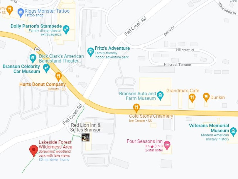
🧭 Where to Find It: The Lakeside Forest Wilderness Area is located just off of Highway 76 on Fall Creek Road. The address is 1550 Fall Creek Road. Parking is flat and ample, but the lot does tend to get pretty full on holidays and other peak times.
There is a gate on the parking lot, which is open from sunrise to sunset.
[](https://www.andbluesky.com/wp-content/uploads/2022/01/Lakeside-Forest-Wilderness-Area-Location-Map.jpg)
🗺️ Trail Map: Branson Parks & Rec has a great **[map of the Lakeside Forest Wilderness Area](https://www.bransonparksandrecreation.com/DocumentCenter/View/11483/LAKESIDE_FOREST_TRAIL_MARKER_MAP-2019?bidId=)** with all of the trail markers.
🌿 Branson Lakeside Forest Wilderness Area Review Coming Soon
***
[](https://www.andbluesky.com/wp-content/uploads/2022/02/roark-creek-trail-branson.jpg)
### Roark Creek Trail
💭 Summary: If you’re looking for a nice, easy walk in the woods where you can chat with a friend and enjoy some nice views of the creek, this is your trail.
🌿Number of trails: 1
📏Trail Length: The first 2.6 miles of the trail are paved, and there’s an additional half mile of natural terrain after that. The trail also connects to a paved pathway that runs all the way down to Branson Landing, an additional 1.2 miles. Eventually, an extension is supposed to be added that will connect this trail to the Branson Waterfall Trail, but the Branson Parks & Rec website has had the note about the eventual extension for about two years now, so….
⏲️Estimated Time:
🚴Bikes: The paved section is great for biking.
🐕: Leashed dogs are welcome, and there’s even a dog park near the parking lot with some fun obstacles, water fountains, and separate areas for large and small dogs.
🔰Difficulty Level: 1
🌿Terrain: Paved except for the final half mile, which is mostly flat and grassy. If you’re looking for a stroller or **wheelchair friendly nature trail in Branson**, this is a great choice\!
📸 Points of Interest: none
🚻 Facilities: You will find restrooms near the entrance to Stockstill Park
❇️ Also On Site: The park includes picnic tables, a sports field, a small playground, tennis courts, and a skate park.
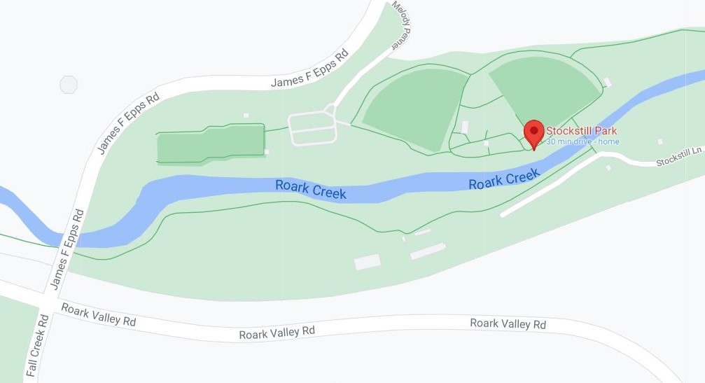
🧭 Where to Find It: This trail can be accessed from two places with the easiest to get to being Stockstill Park, which is located at 625 Stockstill Ln, Branson, MO 65616.
[](https://www.andbluesky.com/wp-content/uploads/2022/01/roark-creek-trail-branson-map.jpg)
🗺️ Trail Map: [City of Branson’s Roark Creek Trail Map](https://media.bransontourismcenter.com/images/bcom/trails/roark-valley-trail.jpg)
🌿 Roark Creek Trail Review Coming Soon
***
### [](https://www.andbluesky.com/wp-content/uploads/2022/02/hiking-4.jpg)
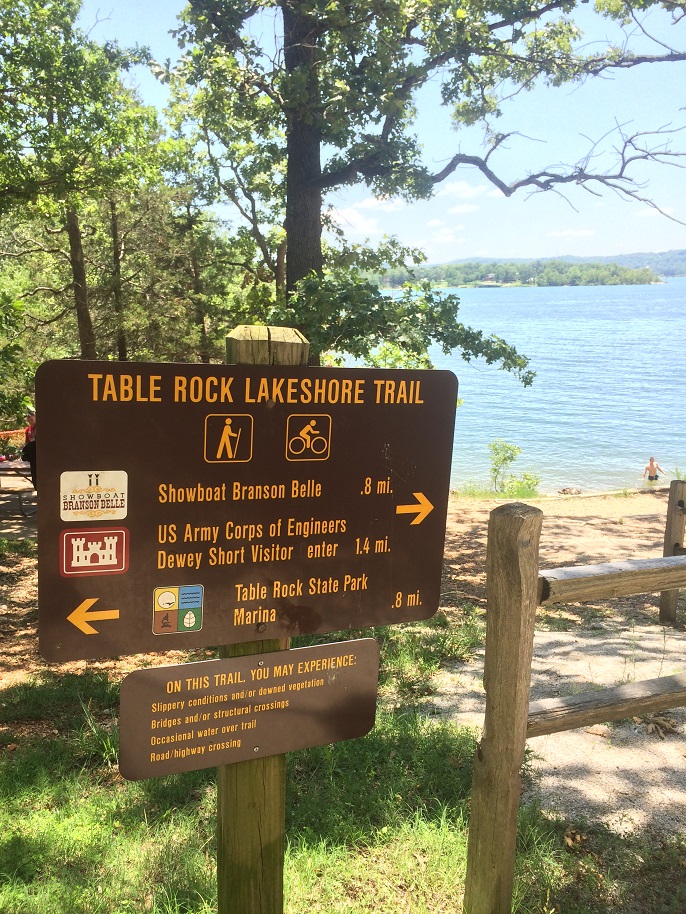
### Table Rock Lakeshore Trail (Dewey Short to State Park Marina)
💭 Summary: Lake views, easy access, great beginner trail. However, that accessibility means it tends to be quite busy with locals and tourists alike through most of the year. You’re probably going to see way more people here than on any of the other Branson hiking trails.
**Note**: I have seen large sections of this trail closed on rare occasions when the lake is very high and covers it., usually in the Spring.
🌿Number of trails: 1
📏Trail Length: The entire trail stretches about 2 and a quarter miles one way, but parking lots along the way make it very easy to do a shorter stretch and you can easily add on a bit of extra distance at each end if you want a longer walk.
⏲️Estimated Time: If you do the entire trail out and back, it takes about round-trip.
🚴Bikes: This trail is very biker-friendly\!
🐕: I always see a lot of dogs here\!
🔰 Difficulty Level: 1
🌿Terrain: Paved. This trail is wide and flat enough for **strollers and wheelchairs**.
📸 Points of Interest:
🚻 Facilities: You will find multiple restrooms along this trail. See the review below for more information.
❇️ Also On Site: This trail passes by the Dewey Short Visitor Center (click to check out my post about it), [the Showboat Branson Belle](https://www.andbluesky.com/evening-aboard-showboat-branson-belle/), and State Park Marina.
🧭 Where to Find It: The trail can be accessed from any of the three locations above, all of which have plenty of parking. Coming from Branson, the easiest way is to take Highway 265 until you cross the dam. The Dewey Short Visitor Center is just the other side of the dam, and continuing on the same road will take you to the other trailheads. If you visit the trail review below, you can find more details on where to park.
[](https://www.andbluesky.com/wp-content/uploads/2022/01/table-rock-lakeshore-trail-location-map.jpg)
🗺️ Trail Map: [MO State Parks Table Rock Lakeshore Trail Map](https://mostateparks.com/sites/mostateparks/files/TrailMap-lakeshore.pdf)
🌿 Table Rock Lakeshore Trail Review
***
[](https://www.andbluesky.com/wp-content/uploads/2020/02/Henning-Conservation-Area-Entrance.jpg)
### Henning Conservation Area
💭 Summary: Just off of Highway 76, this nature area offers several miles worth of trails that are mostly easy to moderate.
🌿Number of trails: 4
📏Trail Length:
- [](https://www.andbluesky.com/wp-content/uploads/2020/02/Henning-conservation-trail-map.jpg)
- ⏲️Estimated Time:
- 🚴 Bikes:
- 🐕
- 🔰 Difficulty Level:
Dewey Bald Trail: 2
Glade Trail: 2.5
Spring Trail: 2
🌿Terrain:Dewey Bald Tower Loop: This trail is **paved** but quite steep in areas, so pushing a stroller or wheelchair would be a pretty good workout. In the fall, the leaves tend to make it surprisingly slippery.Glade Trail: This one ranges from fairly flat to very rocky.
Spring Trail: Natural terrain, fairly smooth.
📸 Points of Interest: There’s an observation tower you can climb on the Dewey Bald Trail and a small lookout point on the Glade Trail.
🚻 Facilities: There is a small restroom near the trail on the right end of the parking lot, but I’d highly suggest hitting the one at the nearby gas station instead if possible, since these are outhouse-style toilets with no sink and sometimes no toilet paper.
❇️ Also On Site: n/a
🧭 Where to Find It: Right on Highway 76 as your are exiting the west side of Branson.
[](https://www.andbluesky.com/wp-content/uploads/2022/01/henning-conservation-hiking-trails-location-branson.jpg)
🗺️ Trail Map: see above
🌿 Review: [**Henning Conservation Area Hiking Trails Review**](https://www.andbluesky.com/hiking-trails-at-ruth-and-paul-henning-conservation-area-in-branson-mo/)
***
[](https://www.andbluesky.com/wp-content/uploads/2022/02/hatchery-nature-trail.jpg)
### Shepherd of the Hills Fish Hatchery Trails
💭 Summary: Located just behind the fish hatchery, these four short trails offer some beautiful scenery.
🌿Number of trails: Four
📏Trail Length:
White River Bluffs Trail: The short loop is .6 miles, the longer loop is 1.5 miles.
White River Corridor Trail: Just under half a mile one way.
Canebrake Trail: About 1/3 mile one way
Fisherman’s Trail: Just under half a mile one way.
- Three of the four trails (all but the White River Bluffs) run along the shore of Lake Taneycomo and come close to connecting to each other, creating a picturesque walk that’s just over a mile one way.⏲️Estimated Time:🚴 Bikes: Sorry, no bikes.🐕: Leashed dogs are welcome.🔰 Difficulty Level: On average, a 2🌿Terrain: Most of these trails are fairly flat, although the White River Corridor trail has a few stairways and the White River Bluffs trail has a moderate elevation gain of about 200 feet.📸 Points of Interest: Some of the trees along these trails are *very* old and thus massive.
🚻 Facilities: Restrooms are available near the picnic area.
❇️ Also On Site: You can tour the Shepherd of the Hills Fish Hatchery for free. (Click the link for my post about it!)
🧭 Where to Find It: The fish hatchery is located on Lake Taneycomo near the dam Dam.
[](https://www.andbluesky.com/wp-content/uploads/2022/01/Branson-fish-hatchery-nature-trails.jpg)
🗺️ Trail Map: [MO Department of Conservation’s Shepherd of the Hills Fish Hatchery Trails Trail Map (PDF)](https://mdc.mo.gov/sites/default/files/2022-01/5601map.pdf)
🌿 Shepherd of the Hills Fish Hatchery Trails Review Coming Soon
***
### Chinquapin Trail at Table Rock State Park
💭 Summary: This trail mostly runs parallel to the Lakeshore Trail but offers more of a “hiking” feeling than its paved companion.
🌿Number of trails: 1
📏Trail Length: 1.2 miles
⏲️Estimated Time: 1 hour
🚴 Bikes:
🐕
🔰 Difficulty Level: 2
🌿Terrain: Natural
📸 Points of Interest: n/a
🚻 Facilities: Restrooms are available near the trail head.
❇️ Also On Site: The area near the trail head has a picnic and barbecue area.
🧭 Where to Find It: The trail begins near the State Park office and ends in State Park Marina.
🗺️ Trail Map: Branson Tourism Center’s [Map of the Chinquapin Trail at Table Rock State Park](https://media.bransontourismcenter.com/images/bcom/trails/tablerock_chinquapin.pdf)
🌿 Review Coming Soon
***
### White River Valley Trails at Table Rock State Park
💭 **Summary**: This interconnected trail system within Table Rock State Park offers more than 10 miles of trails that range from steep and rocky to wildflower-filled fields.
**Note:** These trails are often closed during hunting season and after heavy rains. They also tend to have a lot of mosquitos in the summer and are quite popular with mountain bikers, so you may occasionally have to hop out of their way.
🌿Number of trails: Four
📏Trail Length: **Do not trust the signs** at the trailheads when it comes to distance. All of these trails are longer than it says they are.
[](https://www.andbluesky.com/wp-content/uploads/2022/01/White-River-Valley-Trails-Table-Rock.jpg)
In our experience, the red trail is much closer to 3 miles than 2.5 and the green is more like 1.5. We’ve only done half of the blue trail so far (It basically makes a figure-8) but that section was over two miles, which makes it highly unlikely that the entire thing is only 3 miles. (Reviews on [Alltrails](https://www.alltrails.com/trail/us/missouri/white-river-blue-trail?ref=result-card) list it as anywhere from 3.4 to 3.8 miles.)
⏲️Estimated Time:
🚴 Bikes: These trails are very popular with mountain bikers! We usually see at least a couple while doing the blue trail.
🐕
🔰 Difficulty Level:
🔴 Red Loop: **2-3** Most of the trail is pretty easy, but there are a few areas that got us breathing pretty hard and there’s one stream crossing.
🔵 Blue: Parts of this trail are basically flat, but one section includes a 400-foot elevation gain. See my review for suggested routes if you want to keep your hike at about level **2**, otherwise the full trail is a **3+**.
🟠 Orange: I haven’t personally done this trail yet but I’ll update this page as soon as I do! I checked AllTrails for reviews, but only one person out of over 200 mentioned doing it, and they didn’t offer any details.
🟢 Green Loop: **2** – This is a very odd trail because you feel like you’re hiking in a totally different place every 15 minutes or so. From lush fields with wildflowers to dry and rocky to deep in the woods, all within an hour.
🌿Terrain: Natural. The red and parts of the blue are definitely rocky enough that you need to pay attention to your feet.
📸 Points of Interest: For the most part, there’s not a lot to see here, just a nice walk in the woods. The steep half of the blue trail has an overlook point with nice lake views, and the orange trail has a small waterfall if the weather hasn’t been too dry.
🚻 Facilities:
❇️ Also On Site:
🧭 Where to Find It: These trails are just the other side of the street from the Table Rock Lakeshore Trail described above.
Parking is as follows:
Red: Has a nice, large parking lot – look for signs just past the Dewey Short Center, on the opposite side of the street.
Blue: Just across from the Dewey Short Center is a trail that leads to a dam overlook point. Continue past this, allll the way down the hill, and you’ll come to a small parking lot at the trail head.
Orange: Unfortunately, this trail doesn’t have parking and is only accessible by hiking part of the Green loop or blue loop and then taking the connector trail over to Orange.
Green: This trail has a small parking lot near the Trophy Run Resort.
🗺️ Trail Map: [MO State Parks map of the White River Valley Trails at Table Rock State Park](https://mostateparks.com/sites/mostateparks/files/TrailMap-whiteriver.pdf)
🌿 Reviews:
***
### Boston Ferry Trail
💭 Summary: This short trail is off the beaten path and leads down a hill to an old ferry crossing.
**Note**: Bow and arrow hunting of deer, turkey, and bear is allowed in this area during their respective seasons, you you might want to wear brightly colored clothing if hiking during those times of year.
🌿Number of trails: 1
📏Trail Length: Just under a mile (.94 miles) out and back
⏲️Estimated Time: 45 minutes
🚴 Bikes: No bikes allowed.
Leashed dogs are welcome but coming up the rocky hill might be a lot for little ones.
🔰 Difficulty Level: 3 – Going down is quite easy, but you may feel the trip back up. Thankfully, you are only going uphill for half a mile.
🌿Terrain: This rocky path requires you to watch your feet, but isn’t tricky to navigate. The trial goes downhill all the way to the water, so your return trip is all uphill.
📸 Points of Interest: none
🚻 Facilities: None.
❇️ Also On Site: N/A
🧭 Where to Find It: This one is a bit complicated to get to. From Highway 65, you take the Bee Creek Exit, then turn right on Rinehart Rd. and left on Shary View Rd.
[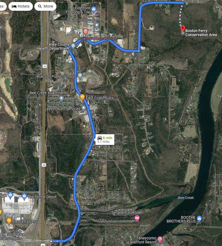](https://www.andbluesky.com/wp-content/uploads/2022/02/boston-ferry-trail-map.jpg)
🗺️ Trail Map: n/a
🌿 Review: I probably won’t be doing this one again to write a full review, but in short I’d only really suggest it if a) you live nearby or b) you’ve done all of the other Branson hiking trails countless times and want to try something new, or if you’re a huge lover of wildflowers and want to see the redbuds and dogwood blooming in the spring. We found it was exciting to try a local trail we didn’t know for a change, but didn’t really feel the need to return. If you’d like more info, you can find a few [photos and reviews on AllTrails](https://www.alltrails.com/trail/us/missouri/boston-ferry)
[](https://www.andbluesky.com/wp-content/uploads/2022/02/boston-ferry-trail-branson-rotated.jpg)
About 85% of the Boston Ferry Trail looks like this, so this is one of the very few photos I took.
***
[](https://www.andbluesky.com/wp-content/uploads/2022/02/branson-boardwalk-trail.jpg)
### Honorable Mention: Branson Boardwalk Trail
💭 Summary: I’m categorizing this one as “honorable mention” because it’s definitely \*not\* a hiking trail. This is a paved path that runs along Lake Taneycomo, passing behind the Branson Landing. However, the parts of the trail on either side of the Landing are fairly nature-y, with towering trees on one side and lots of ducks and geese on the other.
🌿Number of trails: 1
📏Trail Length: 1.1 miles from the bridge pictured above to the end of the trail in North Beach Park
⏲️Estimated Time:
🚴Bikes:
🐕:
🔰 Difficulty Level: 1
🌿Terrain: Paved and flat
📸 Points of Interest:
🚻 Facilities: You’ll find multiple public restrooms in the Branson Landing, which is just a few steps from the path.
❇️ Also On Site: The pathway passes the Branson Landing Fountain, which puts on a show every hour. You’ll also find picnic tables and BBQ grills at North Beach Park.
🧭 Where to Find It:
🗺️ Trail Map:
🌿 Review
**What are your favorite Branson hiking trails?** Which one would you most like to try? Let me know in the comments, and feel free to ask any questions you have\!
[](https://www.andbluesky.com/wp-content/uploads/2022/01/pin-for-later.png)
[](https://www.andbluesky.com/wp-content/uploads/2022/01/Branson-MO-Hiking-Trails.png)
*Dedication: After a year and a half of hiking together at least a couple times of month, I lost my dear hiking buddy Alana in summer of 2021. She kept me company on most of the research hikes that led to this guide, got as excited about cool rocks and moss as I did, and is very, very missed.*
#### Welcome\!

Hi friends! I'm Crystal.
I'm a freelance travel writer and blogger (and cat lady) based in Southwest Missouri. I'm a huge travel nerd and I kept finding myself getting super frustrated when I was trying to research my upcoming trips and the top Google results were all blogs written by people who had clearly never actually experienced the places they were writing about.
I've made it my mission to bring you \*first hand\* experience and tips about amazing places to stay and things to do! Yes, it's WAY more work to do things this way, but I could never recommend a hotel I've never even seen in person, or give you "tips" for a hike I've never done! Everything here is real and honest. I have so much fun digging deep to bring you hidden gems, useful tips, and fascinating stories behind the places I tell you about!
You can contact me at andblueskyblog (at) gmail\!
[](http://www.instagram.com/andblueskyblog) [](http://www.instagram.com/crystalward11)
[](http://www.pinterest.com/Crystal11)
[](http://www.twitter.com/Crystal11)
[](https://www.hellofresh.com/pages/share?c=HS-FQKRJI1QH&utm_campaign=clipboard&utm_couponvalue=120&utm_invitername=Crystal&utm_medium=referral&utm_source=raf-share)
#### Archives
Archives
#### Categories
- [Adventures](https://www.andbluesky.com/category/adventures/)
- [Books](https://www.andbluesky.com/category/books/)
- [Cats](https://www.andbluesky.com/category/cats/)
- [Fashion](https://www.andbluesky.com/category/fashion/)
- [Featured](https://www.andbluesky.com/category/featured/)
- [Horses](https://www.andbluesky.com/category/horses/)
- [Orlando](https://www.andbluesky.com/category/orlando/)
- [Subscription Box Reviews](https://www.andbluesky.com/category/subscription-box-reviews/)
- [Travel](https://www.andbluesky.com/category/travel/)
- [Uncategorized](https://www.andbluesky.com/category/uncategorized/)
- [Yoga](https://www.andbluesky.com/category/yoga/)
#### Tags
[Alabama](https://www.andbluesky.com/tag/alabama/) [aquariums](https://www.andbluesky.com/tag/aquariums/) [Arkansas](https://www.andbluesky.com/tag/arkansas/) [art](https://www.andbluesky.com/tag/art/) [attractions](https://www.andbluesky.com/tag/attractions/) [books](https://www.andbluesky.com/tag/books/) [Branson](https://www.andbluesky.com/tag/branson/) [Branson hiking trails](https://www.andbluesky.com/tag/branson-hiking-trails/) [cabins](https://www.andbluesky.com/tag/cabins/) [cats](https://www.andbluesky.com/tag/cats/) [caves](https://www.andbluesky.com/tag/caves/) [Crescent Hotel](https://www.andbluesky.com/tag/crescent-hotel/) [Dallas](https://www.andbluesky.com/tag/dallas/) [Eureka Springs](https://www.andbluesky.com/tag/eureka-springs/) [Florida](https://www.andbluesky.com/tag/florida/) [food](https://www.andbluesky.com/tag/food/) [Fri](https://www.andbluesky.com/tag/fri/) [Friday](https://www.andbluesky.com/tag/friday/) [Friday Favorites](https://www.andbluesky.com/tag/friday-favorites/) [Friday Favs](https://www.andbluesky.com/tag/friday-favs/) [giveaways](https://www.andbluesky.com/tag/giveaways/) [Goals](https://www.andbluesky.com/tag/goals/) [healthy things](https://www.andbluesky.com/tag/healthy-things/) [hiking trails](https://www.andbluesky.com/tag/hiking-trails/) [historic](https://www.andbluesky.com/tag/historic/) [Hotel](https://www.andbluesky.com/tag/hotel/) [hotel reviews](https://www.andbluesky.com/tag/hotel-reviews/) [hotels](https://www.andbluesky.com/tag/hotels/) [miss](https://www.andbluesky.com/tag/miss/) [Missouri](https://www.andbluesky.com/tag/missouri/) [museums](https://www.andbluesky.com/tag/museums/) [Natural Products](https://www.andbluesky.com/tag/natural-products/) [Orlando attractions](https://www.andbluesky.com/tag/orlando-attractions/) [Show Us Your Books](https://www.andbluesky.com/tag/show-us-your-books/) [spa](https://www.andbluesky.com/tag/spa/) [Springfield](https://www.andbluesky.com/tag/springfield/) [Target](https://www.andbluesky.com/tag/target/) [Texas](https://www.andbluesky.com/tag/texas/) [theme parks](https://www.andbluesky.com/tag/theme-parks/) [Tours](https://www.andbluesky.com/tag/tours/) [vacation rentals](https://www.andbluesky.com/tag/vacation-rentals/) [weekending](https://www.andbluesky.com/tag/weekending/) [wellness](https://www.andbluesky.com/tag/wellness/)
[](http://www.fabletics.com/invite/andbluesky/)
© 2026 \| Proudly Powered by [WordPress](https://www.andbluesky.com/branson-hiking-trails/%20https://wordpress.org/) \| Theme: [Nisarg](https://wordpress.org/themes/nisarg/) |
| Readable Markdown | [](https://www.andbluesky.com/wp-content/uploads/2022/02/Branson-Hiking-Trails.png)
There are countless **outdoor activities in Branson, MO** and the surrounding area, but the **Branson hiking trails** are by far my favorites. Whether you are visiting Branson and want to enjoy the natural beauty of the area or you’re a Branson local looking for something fun to do on your day off, I hope this **Branson hiking trail guide** is helpful for you\!
**\*\*\*This is very much a work in progress and still has missing info but I wanted to go ahead and publish the info I have ready for people planning trips to Branson soon!\*\***
- - **Want to skip straight to the list of trails?** [Click here\!](https://www.andbluesky.com/branson-hiking-trails/#Table-of-contents)
I noticed something when I was searching for a **list of Branson hiking trails** recently: every list I came across was either seriously lacking in detail or compiled by someone who had clearly never actually done any of the trails. I also found guides that would just describe a trail as “moderate” or “easy” very frustrating. Easy for who? Give me details\!
So I wanted to put together a guide to Branson hiking trails that’s actually helpful. **I’ve tried to include everything I can think of to help you know what to expect.** Is this a trail you can bring small kids on, or is it better for experienced hikers? Do you need waterproof shoes to cross creeks and make your way through mud? If there are multiple trails at one location, what’s the best one if you have one hour and want the best experience?
**I’ve almost hiked every trail on this list multiple times**, usually 10+ times. For the few exceptions that I haven’t gotten to yet, I did extensive searching to pull together as much information as possible for you and will continue to update this page as I get the chance to explore them in person.
## To keep things organized and easy, I’ve included the following info for each of the Branson hiking trails:
💭 **Summary**: The trail summed up in a few words so that you can quickly decide if you want to learn more.
🌿 **Number of trails**: Many locations have just one trail, but others have several to choose from.
**⏲️ Estimated Time**: A ballpark figure of how long to allow if you’re walking a trail at a moderate pace and perhaps stopping to take a few photos. My goal is to at least give you an idea if you should plan on 20 minutes or two hours.
🚴 **Bikes?** I’m not a mountain biker (yet!) but a lot of these trails are popular with people who are, and a couple are great for regular bikes, too.
🐕 **Dog Friendly Hiking Trails in Branson**: If a trail has any signs about whether four-legged friends are welcome or not, I’ll include that, plus whether or not they have bags to clean up after them or any other relevant info. (Side note: If you go hiking with an adventure cat, I totally want to see photos!)
🔰 **Difficulty Level**: It’s hard to give objective difficulty ratings; one person’s walk in the park is another person’s Mt. Everest. Since our definitions of the “average person” might be quite different from each other, I’m basing my ratings on someone who is at a fitness level where you’re comfortable walking for an hour but not a serious athlete. I try to include info for those with mobility disabilities, because the outdoors are for everyone. I’ll be using the following 1-5 rating system to help you decide if a trail is right for you:
**1 – A casual stroll.** This trail is suitable for almost anyone, including small children and those with limited fitness levels. Perfect for a long chat with your walking buddy while enjoying the scenery.
**2 – A fairly easy trail.** This may be a bit longer or rougher than a level 1 trail, or offer some sort of obstacle like crossing a stream that may somewhat limit who can navigate it. You might need to be able to step over large rocks or walk up and down some moderate hills, but otherwise it’s just a nice walk in the woods.
**3- A moderate trail.** This trail might be a bit of a workout, but still suitable for our “average” person described above.
**4- Moderately difficult** – A physically challenging trail, either in terms of length, rugged terrain, or other factors.
**5- Difficult** – A serious challenge. To be honest, it’s unlikely you’ll see me reviewing any of these. I’m a writer who spends most of my time in front of a laptop! If you’d like to review difficult Branson hiking trails (if we even have any here?) for this site, though, let me know\!
🌿 **Terrain** makes a big difference! A half mile long trail that’s rocky and steep can be ten times more exhausting than a two mile long flat, paved trail, in my experience.
- **Paved**: I’ll note if these are suitable for strollers and wheelchairs.
- **Smooth**: Not paved, but a mostly flat surface. This may include trails with gravel or wood chip footing, or dirt trails that are not very rocky. You can probably do these in whatever comfortable shoes you happened to pack.
- **Natural**: A natural dirt or grassy trail. May be a bit hilly or rocky (skip the flip-flops for these!), but not especially rugged.
- **Rough**: Expect steep hills, rocky footing, or otherwise uneven footing that is going to require your attention.
📸 **Points of Interest**: Is there a scenic overlook point, an old cabin, a cool waterfall, or something else to see along the way?
🚻 **Facilities**: Are there restrooms, water fountains, or sinks available near the trail? If so, they will be listed here.
❇️ **Also On Site:** Playgrounds, gift shops, attractions, and anything else you might find at the same location.
🧭 **Where to Find It:** How to get to the trail. I’ve provided an address you can use in your GPS or Maps app if possible, otherwise nearby streets and landmarks are given. Parking is also noted here.
🗺️ **Trail Map:** If a map of the trail is available online, you will find a link here.
🌿 **Review**: If I have blogged about the trail, you will find a link to the post about my experience. Check these out for more in depth info about each route as well as plenty of photos, suggested routes, the closest place to find a bottle of water or a restroom if there are none on-site, suggested footwear, and my personal tips on how to best enjoy each trail.
Note: For some reason my table of contents links take you to a couple of lines below where each one actually starts, so if you use them to navigate just scroll up a bit to get to the actual beginning of each trail. If anyone is a HTML wizard and knows how to fix this, please share\!
## Branson Hiking Trails Table of Contents:
- - [Branson Waterfall Trail](https://www.andbluesky.com/branson-hiking-trails/#Branson-Waterfall-Trail)
- [Lakeside Forest Wilderness Area Trails](https://www.andbluesky.com/branson-hiking-trails/#Lakeside-Wilderness-Area)
- [Roark Creek Trail](https://www.andbluesky.com/branson-hiking-trails/#Roark-Creek-Trail)
- [Table Rock Lakeshore Trail](https://www.andbluesky.com/branson-hiking-trails/#Table-Rock-Lakeshore-Trail)
- [Henning Conservation Area](https://www.andbluesky.com/branson-hiking-trails/#Henning)
- [White River Valley Trail System](https://www.andbluesky.com/branson-hiking-trails/#White-River-Valley-Trails)
- [Boston Ferry Trail](https://www.andbluesky.com/branson-hiking-trails/#Boston-Ferry-Trail)
- [Shepherd of the Hills Fish Hatchery Trails](https://www.andbluesky.com/branson-hiking-trails/#Fish-Hatchery-Trails)
- [Chinquapin Trail at Table Rock State Park](https://www.andbluesky.com/branson-hiking-trails/#Chinquapin-Trail)
- [Branson Boardwalk Trail](https://www.andbluesky.com/branson-hiking-trails/#Branson-Boardwalk)
If you know of any Branson hiking trails I’ve left out, please let me know\!
***
[](https://www.andbluesky.com/wp-content/uploads/2022/02/waterfall-trail-in-branson.jpg)
### Branson Waterfall Trail
💭 Summary: A short trail that crosses Roark Creek and leads to a small waterfall.
🌿Number of trails: 1
📏Trail Length: About 1.4 miles out and back
⏲️Estimated Time: 45 minutes
🚴 Bikes are not allowed on this trail.
🐕: Leashed dogs are welcome
🔰 Difficulty Level: 2.5
🌿Terrain: Natural & Rough. Expect some small steep hills, a few shallow streams to ford, and occasional slippery mud.
📸 Points of Interest: The trail ends at a small waterfall.
🚻 Facilities: There are no restrooms on-site.
❇️ Also On Site: N/A, just the trail.
🧭 Where to Find It: The Branson Waterfall Trail runs behind [Westgate Branson Woods Resort](https://www.jdoqocy.com/click-100547241-13828058?url=https%3A%2F%2Fwww.hotels.com%2Fho227965%2Fwestgate-branson-woods-resort-and-cabins-branson-united-states-of-america%2F%3Fchkin%3D2022-03-15%26chkout%3D2022-03-16%26x_pwa%3D1%26rfrr%3DHSR%26pwa_ts%3D1645933397152%26referrerUrl%3DaHR0cHM6Ly93d3cuaG90ZWxzLmNvbS9Ib3RlbC1TZWFyY2g%253D%26useRewards%3Dfalse%26rm1%3Da2%26regionId%3D6058734%26destination%3DBranson%252C%2BMissouri%252C%2BUnited%2BStates%2Bof%2BAmerica%26destType%3DCURRENT_LOCATION%26neighborhoodId%3D6328963%26selected%3D1188585%26sort%3DRECOMMENDED%26top_dp%3D89%26top_cur%3DUSD%26semdtl%3D%26userIntent%3D%26selectedRoomType%3D54464%26selectedRatePlan%3D123965%26expediaPropertyId%3D1188585), which is located on Roark Valley Road near where it intersects with Shepherd of the Hills Expressway. Trail parking is available across the street from the resort near the Charcoal Factory. You can use the following address for directions: 1902 Roark Valley Rd, Branson, MO 65616
[](https://www.andbluesky.com/wp-content/uploads/2022/01/waterfall-map.jpg)
🗺️ Trail Map: [City of Branson Waterfall Trail Map](https://media.bransontourismcenter.com/images/bcom/trails/waterfall-trail-map.jpg)
🌿 Branson Waterfall Trail Review Coming Soon
***
[](https://www.andbluesky.com/wp-content/uploads/2022/02/lakeside-forest-trails-branson.jpg)
### Branson Lakeside Forest Wilderness Area Trails
💭 Summary: Just off the 76-strip, these trails wind through a historic homestead and offer some great lake views.
**Note**: This trail system has an interactive trail map that you can scan a QR code for, but I haven’t tried this out yet. I’ll update when I do\!
🌿Number of trails: Technically, there are 5: the red, yellow, green, blue, and purple. However, these all connect with each other at multiple points, so you can easily combine pieces of each one to make your own route.
📏Trail Length:
Bluff Trail (blue) – Half a mile
Ridge Trail (red) – 2.4 miles
Owen Drive Trail (yellow) – Just under half a mile
Stone Wall Trail (green) – 1/3 mile
Taneycomo Trail (purple) – 1.06 miles
⏲️Estimated Time: If you just want to walk from the parking lot out to the cabin and back, it’s about 20 minutes. Adding the green trail puts you at around 30 minutes, or you can add the large loop of the red trail instead to spend just under an hour here. Doing every trail would take 2-3 hours and way more stamina than I have. 😂
🚴 The sign says “foot traffic only”.
🐕 Leashed dogs are welcome. Other than service dogs, they’re not allowed on the stone steps for safety reasons (navigating the steps is tough enough without dodging doggos, too), but I have seen a few there.
🔰 Difficulty Level and 🌿Terrain: I’m combining these sections because the difficulty level of these trails is almost totally dependent on the type of terrain. The trails here offer a diverse range of difficulty levels, from 1-4.
🟡 The yellow trail is definitely the easiest section with only a slight incline and fairly flat natural footing, and you’ll see people of all ages out on it. However, the natural terrain keeps it from being wheelchair or stroller friendly.
🔵 The map at the trailhead calls the blue trail “easy”, but given that this is the section where you’re either going up or down over 300 stairs made of natural rock, I beg to differ! I’d rate this a solid **3** if you’re going down the stairs, 4+ if you’re coming back up. (If you’re headed to the Grotto area, I suggest going down the stairs and back up the alternate, stair-free route!)
🔴 The large loop of the red trail is a great choice if you want a nice long walk that’s not too strenuous. I usually stop at a bench for a quick rest coming back up the hill towards the end, but overall it’s around a **2\.5**. However, the map also classifies the trail that leads down to the grotto as an alternate route to the stairs as part of the red trail, and that section is significantly steeper and there are sections where you’re walking on a fairly narrow path near a pretty steep drop-off.
🟢 The green trail has a few small hills, some rocky parts, and one spot where you need to be able to step over something that’s a little less than 2 feet high. Overall, I’d rate it a **2** though.
🟣 The purple trail is definitely the most rugged area but it includes two caves, plus the grotto and waterfall. Some areas could be dangerous after heavy rain or snow. Calling this a **4**.
📸 Points of Interest: The remains of a historic cabin, a hand-built stone wall, a few small caves, and the 338 stone steps that were put in place by the original homesteaders. There’s also a large stone grotto that occasionally has a waterfall if there’s been a lot of rain.
🚻 Facilities: Well-maintained restrooms with sinks are located near the trail head, where you’ll also find a few picnic tables.
❇️ Also On Site: There is a small playground near the parking lot.
🧭 Where to Find It: The Lakeside Forest Wilderness Area is located just off of Highway 76 on Fall Creek Road. The address is 1550 Fall Creek Road. Parking is flat and ample, but the lot does tend to get pretty full on holidays and other peak times.
There is a gate on the parking lot, which is open from sunrise to sunset.
[](https://www.andbluesky.com/wp-content/uploads/2022/01/Lakeside-Forest-Wilderness-Area-Location-Map.jpg)
🗺️ Trail Map: Branson Parks & Rec has a great **[map of the Lakeside Forest Wilderness Area](https://www.bransonparksandrecreation.com/DocumentCenter/View/11483/LAKESIDE_FOREST_TRAIL_MARKER_MAP-2019?bidId=)** with all of the trail markers.
🌿 Branson Lakeside Forest Wilderness Area Review Coming Soon
***
[](https://www.andbluesky.com/wp-content/uploads/2022/02/roark-creek-trail-branson.jpg)
### Roark Creek Trail
💭 Summary: If you’re looking for a nice, easy walk in the woods where you can chat with a friend and enjoy some nice views of the creek, this is your trail.
🌿Number of trails: 1
📏Trail Length: The first 2.6 miles of the trail are paved, and there’s an additional half mile of natural terrain after that. The trail also connects to a paved pathway that runs all the way down to Branson Landing, an additional 1.2 miles. Eventually, an extension is supposed to be added that will connect this trail to the Branson Waterfall Trail, but the Branson Parks & Rec website has had the note about the eventual extension for about two years now, so….
⏲️Estimated Time:
🚴Bikes: The paved section is great for biking.
🐕: Leashed dogs are welcome, and there’s even a dog park near the parking lot with some fun obstacles, water fountains, and separate areas for large and small dogs.
🔰Difficulty Level: 1
🌿Terrain: Paved except for the final half mile, which is mostly flat and grassy. If you’re looking for a stroller or **wheelchair friendly nature trail in Branson**, this is a great choice\!
📸 Points of Interest: none
🚻 Facilities: You will find restrooms near the entrance to Stockstill Park
❇️ Also On Site: The park includes picnic tables, a sports field, a small playground, tennis courts, and a skate park.
🧭 Where to Find It: This trail can be accessed from two places with the easiest to get to being Stockstill Park, which is located at 625 Stockstill Ln, Branson, MO 65616.
[](https://www.andbluesky.com/wp-content/uploads/2022/01/roark-creek-trail-branson-map.jpg)
🗺️ Trail Map: [City of Branson’s Roark Creek Trail Map](https://media.bransontourismcenter.com/images/bcom/trails/roark-valley-trail.jpg)
🌿 Roark Creek Trail Review Coming Soon
***
### [](https://www.andbluesky.com/wp-content/uploads/2022/02/hiking-4.jpg)
### Table Rock Lakeshore Trail (Dewey Short to State Park Marina)
💭 Summary: Lake views, easy access, great beginner trail. However, that accessibility means it tends to be quite busy with locals and tourists alike through most of the year. You’re probably going to see way more people here than on any of the other Branson hiking trails.
**Note**: I have seen large sections of this trail closed on rare occasions when the lake is very high and covers it., usually in the Spring.
🌿Number of trails: 1
📏Trail Length: The entire trail stretches about 2 and a quarter miles one way, but parking lots along the way make it very easy to do a shorter stretch and you can easily add on a bit of extra distance at each end if you want a longer walk.
⏲️Estimated Time: If you do the entire trail out and back, it takes about round-trip.
🚴Bikes: This trail is very biker-friendly\!
🐕: I always see a lot of dogs here\!
🔰 Difficulty Level: 1
🌿Terrain: Paved. This trail is wide and flat enough for **strollers and wheelchairs**.
📸 Points of Interest:
🚻 Facilities: You will find multiple restrooms along this trail. See the review below for more information.
❇️ Also On Site: This trail passes by the Dewey Short Visitor Center (click to check out my post about it), [the Showboat Branson Belle](https://www.andbluesky.com/evening-aboard-showboat-branson-belle/), and State Park Marina.
🧭 Where to Find It: The trail can be accessed from any of the three locations above, all of which have plenty of parking. Coming from Branson, the easiest way is to take Highway 265 until you cross the dam. The Dewey Short Visitor Center is just the other side of the dam, and continuing on the same road will take you to the other trailheads. If you visit the trail review below, you can find more details on where to park.
[](https://www.andbluesky.com/wp-content/uploads/2022/01/table-rock-lakeshore-trail-location-map.jpg)
🗺️ Trail Map: [MO State Parks Table Rock Lakeshore Trail Map](https://mostateparks.com/sites/mostateparks/files/TrailMap-lakeshore.pdf)
🌿 Table Rock Lakeshore Trail Review
***
[](https://www.andbluesky.com/wp-content/uploads/2020/02/Henning-Conservation-Area-Entrance.jpg)
### Henning Conservation Area
💭 Summary: Just off of Highway 76, this nature area offers several miles worth of trails that are mostly easy to moderate.
🌿Number of trails: 4
📏Trail Length:
- [](https://www.andbluesky.com/wp-content/uploads/2020/02/Henning-conservation-trail-map.jpg)
- ⏲️Estimated Time:
- 🚴 Bikes:
- 🐕
- 🔰 Difficulty Level:
Dewey Bald Trail: 2
Glade Trail: 2.5
Spring Trail: 2
🌿Terrain:Dewey Bald Tower Loop: This trail is **paved** but quite steep in areas, so pushing a stroller or wheelchair would be a pretty good workout. In the fall, the leaves tend to make it surprisingly slippery.Glade Trail: This one ranges from fairly flat to very rocky.
Spring Trail: Natural terrain, fairly smooth.
📸 Points of Interest: There’s an observation tower you can climb on the Dewey Bald Trail and a small lookout point on the Glade Trail.
🚻 Facilities: There is a small restroom near the trail on the right end of the parking lot, but I’d highly suggest hitting the one at the nearby gas station instead if possible, since these are outhouse-style toilets with no sink and sometimes no toilet paper.
❇️ Also On Site: n/a
🧭 Where to Find It: Right on Highway 76 as your are exiting the west side of Branson.
[](https://www.andbluesky.com/wp-content/uploads/2022/01/henning-conservation-hiking-trails-location-branson.jpg)
🗺️ Trail Map: see above
🌿 Review: [**Henning Conservation Area Hiking Trails Review**](https://www.andbluesky.com/hiking-trails-at-ruth-and-paul-henning-conservation-area-in-branson-mo/)
***
[](https://www.andbluesky.com/wp-content/uploads/2022/02/hatchery-nature-trail.jpg)
### Shepherd of the Hills Fish Hatchery Trails
💭 Summary: Located just behind the fish hatchery, these four short trails offer some beautiful scenery.
🌿Number of trails: Four
📏Trail Length:
White River Bluffs Trail: The short loop is .6 miles, the longer loop is 1.5 miles.
White River Corridor Trail: Just under half a mile one way.
Canebrake Trail: About 1/3 mile one way
Fisherman’s Trail: Just under half a mile one way.
- Three of the four trails (all but the White River Bluffs) run along the shore of Lake Taneycomo and come close to connecting to each other, creating a picturesque walk that’s just over a mile one way.⏲️Estimated Time:🚴 Bikes: Sorry, no bikes.🐕: Leashed dogs are welcome.🔰 Difficulty Level: On average, a 2🌿Terrain: Most of these trails are fairly flat, although the White River Corridor trail has a few stairways and the White River Bluffs trail has a moderate elevation gain of about 200 feet.📸 Points of Interest: Some of the trees along these trails are *very* old and thus massive.
🚻 Facilities: Restrooms are available near the picnic area.
❇️ Also On Site: You can tour the Shepherd of the Hills Fish Hatchery for free. (Click the link for my post about it!)
🧭 Where to Find It: The fish hatchery is located on Lake Taneycomo near the dam Dam.
[](https://www.andbluesky.com/wp-content/uploads/2022/01/Branson-fish-hatchery-nature-trails.jpg)
🗺️ Trail Map: [MO Department of Conservation’s Shepherd of the Hills Fish Hatchery Trails Trail Map (PDF)](https://mdc.mo.gov/sites/default/files/2022-01/5601map.pdf)
🌿 Shepherd of the Hills Fish Hatchery Trails Review Coming Soon
***
### Chinquapin Trail at Table Rock State Park
💭 Summary: This trail mostly runs parallel to the Lakeshore Trail but offers more of a “hiking” feeling than its paved companion.
🌿Number of trails: 1
📏Trail Length: 1.2 miles
⏲️Estimated Time: 1 hour
🚴 Bikes:
🐕
🔰 Difficulty Level: 2
🌿Terrain: Natural
📸 Points of Interest: n/a
🚻 Facilities: Restrooms are available near the trail head.
❇️ Also On Site: The area near the trail head has a picnic and barbecue area.
🧭 Where to Find It: The trail begins near the State Park office and ends in State Park Marina.
🗺️ Trail Map: Branson Tourism Center’s [Map of the Chinquapin Trail at Table Rock State Park](https://media.bransontourismcenter.com/images/bcom/trails/tablerock_chinquapin.pdf)
🌿 Review Coming Soon
***
### White River Valley Trails at Table Rock State Park
💭 **Summary**: This interconnected trail system within Table Rock State Park offers more than 10 miles of trails that range from steep and rocky to wildflower-filled fields.
**Note:** These trails are often closed during hunting season and after heavy rains. They also tend to have a lot of mosquitos in the summer and are quite popular with mountain bikers, so you may occasionally have to hop out of their way.
🌿Number of trails: Four
📏Trail Length: **Do not trust the signs** at the trailheads when it comes to distance. All of these trails are longer than it says they are.
[](https://www.andbluesky.com/wp-content/uploads/2022/01/White-River-Valley-Trails-Table-Rock.jpg)
In our experience, the red trail is much closer to 3 miles than 2.5 and the green is more like 1.5. We’ve only done half of the blue trail so far (It basically makes a figure-8) but that section was over two miles, which makes it highly unlikely that the entire thing is only 3 miles. (Reviews on [Alltrails](https://www.alltrails.com/trail/us/missouri/white-river-blue-trail?ref=result-card) list it as anywhere from 3.4 to 3.8 miles.)
⏲️Estimated Time:
🚴 Bikes: These trails are very popular with mountain bikers! We usually see at least a couple while doing the blue trail.
🐕
🔰 Difficulty Level:
🔴 Red Loop: **2-3** Most of the trail is pretty easy, but there are a few areas that got us breathing pretty hard and there’s one stream crossing.
🔵 Blue: Parts of this trail are basically flat, but one section includes a 400-foot elevation gain. See my review for suggested routes if you want to keep your hike at about level **2**, otherwise the full trail is a **3+**.
🟠 Orange: I haven’t personally done this trail yet but I’ll update this page as soon as I do! I checked AllTrails for reviews, but only one person out of over 200 mentioned doing it, and they didn’t offer any details.
🟢 Green Loop: **2** – This is a very odd trail because you feel like you’re hiking in a totally different place every 15 minutes or so. From lush fields with wildflowers to dry and rocky to deep in the woods, all within an hour.
🌿Terrain: Natural. The red and parts of the blue are definitely rocky enough that you need to pay attention to your feet.
📸 Points of Interest: For the most part, there’s not a lot to see here, just a nice walk in the woods. The steep half of the blue trail has an overlook point with nice lake views, and the orange trail has a small waterfall if the weather hasn’t been too dry.
🚻 Facilities:
❇️ Also On Site:
🧭 Where to Find It: These trails are just the other side of the street from the Table Rock Lakeshore Trail described above.
Parking is as follows:
Red: Has a nice, large parking lot – look for signs just past the Dewey Short Center, on the opposite side of the street.
Blue: Just across from the Dewey Short Center is a trail that leads to a dam overlook point. Continue past this, allll the way down the hill, and you’ll come to a small parking lot at the trail head.
Orange: Unfortunately, this trail doesn’t have parking and is only accessible by hiking part of the Green loop or blue loop and then taking the connector trail over to Orange.
Green: This trail has a small parking lot near the Trophy Run Resort.
🗺️ Trail Map: [MO State Parks map of the White River Valley Trails at Table Rock State Park](https://mostateparks.com/sites/mostateparks/files/TrailMap-whiteriver.pdf)
🌿 Reviews:
***
### Boston Ferry Trail
💭 Summary: This short trail is off the beaten path and leads down a hill to an old ferry crossing.
**Note**: Bow and arrow hunting of deer, turkey, and bear is allowed in this area during their respective seasons, you you might want to wear brightly colored clothing if hiking during those times of year.
🌿Number of trails: 1
📏Trail Length: Just under a mile (.94 miles) out and back
⏲️Estimated Time: 45 minutes
🚴 Bikes: No bikes allowed.
Leashed dogs are welcome but coming up the rocky hill might be a lot for little ones.
🔰 Difficulty Level: 3 – Going down is quite easy, but you may feel the trip back up. Thankfully, you are only going uphill for half a mile.
🌿Terrain: This rocky path requires you to watch your feet, but isn’t tricky to navigate. The trial goes downhill all the way to the water, so your return trip is all uphill.
📸 Points of Interest: none
🚻 Facilities: None.
❇️ Also On Site: N/A
🧭 Where to Find It: This one is a bit complicated to get to. From Highway 65, you take the Bee Creek Exit, then turn right on Rinehart Rd. and left on Shary View Rd.
[](https://www.andbluesky.com/wp-content/uploads/2022/02/boston-ferry-trail-map.jpg)
🗺️ Trail Map: n/a
🌿 Review: I probably won’t be doing this one again to write a full review, but in short I’d only really suggest it if a) you live nearby or b) you’ve done all of the other Branson hiking trails countless times and want to try something new, or if you’re a huge lover of wildflowers and want to see the redbuds and dogwood blooming in the spring. We found it was exciting to try a local trail we didn’t know for a change, but didn’t really feel the need to return. If you’d like more info, you can find a few [photos and reviews on AllTrails](https://www.alltrails.com/trail/us/missouri/boston-ferry)
[](https://www.andbluesky.com/wp-content/uploads/2022/02/boston-ferry-trail-branson-rotated.jpg)
About 85% of the Boston Ferry Trail looks like this, so this is one of the very few photos I took.
***
[](https://www.andbluesky.com/wp-content/uploads/2022/02/branson-boardwalk-trail.jpg)
### Honorable Mention: Branson Boardwalk Trail
💭 Summary: I’m categorizing this one as “honorable mention” because it’s definitely \*not\* a hiking trail. This is a paved path that runs along Lake Taneycomo, passing behind the Branson Landing. However, the parts of the trail on either side of the Landing are fairly nature-y, with towering trees on one side and lots of ducks and geese on the other.
🌿Number of trails: 1
📏Trail Length: 1.1 miles from the bridge pictured above to the end of the trail in North Beach Park
⏲️Estimated Time:
🚴Bikes:
🐕:
🔰 Difficulty Level: 1
🌿Terrain: Paved and flat
📸 Points of Interest:
🚻 Facilities: You’ll find multiple public restrooms in the Branson Landing, which is just a few steps from the path.
❇️ Also On Site: The pathway passes the Branson Landing Fountain, which puts on a show every hour. You’ll also find picnic tables and BBQ grills at North Beach Park.
🧭 Where to Find It:
🗺️ Trail Map:
🌿 Review
**What are your favorite Branson hiking trails?** Which one would you most like to try? Let me know in the comments, and feel free to ask any questions you have\!
[](https://www.andbluesky.com/wp-content/uploads/2022/01/pin-for-later.png)
[](https://www.andbluesky.com/wp-content/uploads/2022/01/Branson-MO-Hiking-Trails.png)
*Dedication: After a year and a half of hiking together at least a couple times of month, I lost my dear hiking buddy Alana in summer of 2021. She kept me company on most of the research hikes that led to this guide, got as excited about cool rocks and moss as I did, and is very, very missed.* |
| Shard | 25 (laksa) |
| Root Hash | 4152460122402732625 |
| Unparsed URL | com,andbluesky!www,/branson-hiking-trails/ s443 |