ℹ️ Skipped - page is already crawled
| Filter | Status | Condition | Details |
|---|---|---|---|
| HTTP status | PASS | download_http_code = 200 | HTTP 200 |
| Age cutoff | PASS | download_stamp > now() - 6 MONTH | 0 months ago |
| History drop | PASS | isNull(history_drop_reason) | No drop reason |
| Spam/ban | PASS | fh_dont_index != 1 AND ml_spam_score = 0 | ml_spam_score=0 |
| Canonical | PASS | meta_canonical IS NULL OR = '' OR = src_unparsed | Not set |
| Property | Value |
|---|---|
| URL | https://mount-everest3d.com/ |
| Last Crawled | 2026-04-16 08:56:49 (19 hours ago) |
| First Indexed | 2021-03-25 20:45:37 (5 years ago) |
| HTTP Status Code | 200 |
| Meta Title | Mount Everest 3D |
| Meta Description | Explore Mount Everest with our high-resolution 3D map and discover all routes for trekking and mountaineering. |
| Meta Canonical | null |
| Boilerpipe Text | Slider 1
3D Map of Mt. Everest & the Himalaya
>> Load 3D Map
Interactive 3D map of Mount Everest, the Himalaya and popular trekking tours
We created an interactive 3D map of Mount Everest and the Himalaya which is unique in its resolution, unparalleled in detail, and based on the latest satellite technology. The map includes the two most-travelled routes to the highest mountain on Earth, all historical routes and the most famous trekking routes in the Khumbu region.
If you plan a trip to Mount Everest, then
install the RealityMaps app version now
!
Video - route to the summit of Mount Everest
Video - route to the summit of Mount Everest
The video shows the route from Lukla through the Khumbu region to the Base Camp of Mount Everest. From there, it leads through the dangerous Khumbu icefall, followed by the glacial valley of the Western Cwm, where Camp 1 and Camp 2 are located. A steep ascent then leads up Lhotse Face to Camp 4 on South Col at roughly 8000 m. On the summit day, climbers need to first need to master the Southeast ridge and Hillary Step, before they finally reach the summit. Find out more about all routes to the roof of the world and its climbing
history
.
Trekking and climbing peaks in the Everest area
The Everest region offers a multitude of trekking tours. The Earth’s ‘ceiling’ makes a profound impression on those travelling here. The local landscape is defined by its many 8,000 m peaks – Mount Everest, Lhotse and Makalu in particular- but is also appreciated for aesthetically-pleasing peaks like Ama Dablam and Pumori. Along with the classic expeditions to Everest Base Camp, plenty more trekking summits await, accessible via comfortable to demanding ascents.
Find your adventure
RealityMaps App - Ultra realistic 3D maps for adventurers
RealityMaps App - Ultra realistic 3D maps for adventurers
Professional mountaineers rely on the photo-realistic, three-dimensional maps of 3D RealityMaps. If you also want to use the unique maps on tour, then download the RealityMaps App now!
Get inspired by thousands hiking-, mountain- and bike routes in the Himalaya, the Alps, the Pyrenees and the Canary and Balearic Islands.
More information at
www.realitymaps.app
3D Reality Maps was single handedly the best part of my expedition for my friends and family back home. With accurate live tracking on great quality 3D maps they could truly feel part of the climb, every step of the way! I had messages from family saying that the 3D Map was the first and last thing they checked everyday as well as being able to zoom in and out and look at the other mountains in the area too
Jon Gupta
High Altitude
Expedition Leader
Visiting the routes virtually and evaluating options step by step in combination with tour reports was very valuable for my preparation – at the same time, the 3D live tracking made communication a lot easier and helped many people to participate
Jost Kobusch
Alpinist
Unique route planner and GPS navigation tool
The award-winning RealityMaps app is the perfect tool for planning your next outdoor adventure. The
ultra realistic 3D representation of the mountain landscape
allows an intuitive, realistic assessment of the terrain and the technical requirements of a tour.
On the way the digitized landscape is displayed in 3D on your smartphone.
Your current location is shown live on the map
. This this simplifies orientation on the go. You can navigate freely in the map and you can check not yet visible parts of your route. Your planned track and other important information is displayed onscreen.
Unique route planner and GPS navigation tool
Unique route planner and GPS navigation tool
The award-winning RealityMaps app is the perfect tool for planning your next outdoor adventure. The
ultra realistic 3D representation of the mountain landscape
allows an intuitive, realistic assessment of the terrain and the technical requirements of a tour.
On the way the digitized landscape is displayed in 3D on your smartphone.
Your current location is shown live on the map
. This this simplifies orientation on the go. You can navigate freely in the map and you can check not yet visible parts of your route. Your planned track and other important information is displayed onscreen.
GPS tracking
3D RealityMaps GmbH offers GPS tracking services for individuals and expeditions in the Himalaya and especially Khumbu Region of Mount Everest. GPS tracking devices such as Garmin inReach or SPOT devices are supported. GPS positions are instantly displayed in the interactive 3D map. This allows followers, interested parties and family members to follow the progress of the expedition in real-time from home. |
| Markdown | [Skip to content](https://mount-everest3d.com/#main)
[](https://mount-everest3d.com/)
- [Home](https://mount-everest3d.com/)
- [3D Map](https://og.realitymaps.de/RealityMaps/?mount-everest)
- [Live Tracking](https://og.realitymaps.de/RealityMaps/?live-tracking&lang=en)
- [Tours](https://mount-everest3d.com/tours/)
- [App](https://mount-everest3d.com/apps/)
- [History](https://mount-everest3d.com/history/)
- [Deutsch](https://mount-everest3d.com/de/)
- [English](https://mount-everest3d.com/)
Menu
- [Home](https://mount-everest3d.com/)
- [3D Map](https://og.realitymaps.de/RealityMaps/?mount-everest)
- [Live Tracking](https://og.realitymaps.de/RealityMaps/?live-tracking&lang=en)
- [Tours](https://mount-everest3d.com/tours/)
- [App](https://mount-everest3d.com/apps/)
- [History](https://mount-everest3d.com/history/)
- [Deutsch](https://mount-everest3d.com/de/)
- [English](https://mount-everest3d.com/)
Slider 1
## 3D Map of Mt. Everest & the Himalaya
[\>\> Load 3D Map](https://mount-everest3d.com/3d-map/)
Slider 2
## Trekking in the Khumbu Region
[\>\> Discover routes](https://mount-everest3d.com/tours)
Slider 3
## RealityMaps App
### Outdoor Navigation with ultra realistic 3D Maps
[\>\> Get the App](https://mount-everest3d.com/app)


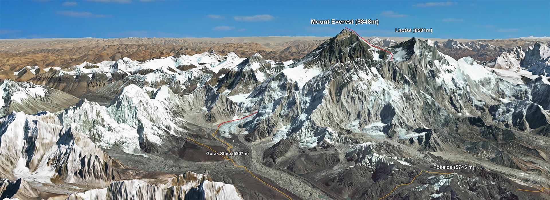
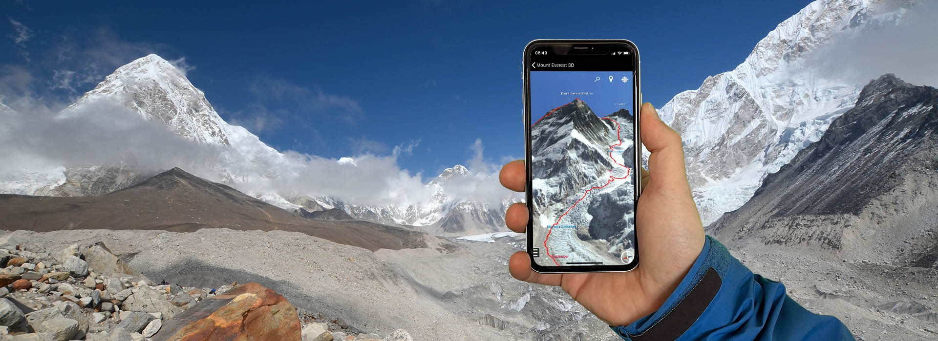
# Interactive 3D map of Mount Everest, the Himalaya and popular trekking tours
We created an interactive 3D map of Mount Everest and the Himalaya which is unique in its resolution, unparalleled in detail, and based on the latest satellite technology. The map includes the two most-travelled routes to the highest mountain on Earth, all historical routes and the most famous trekking routes in the Khumbu region. If you plan a trip to Mount Everest, then **[install the RealityMaps app version now](https://mount-everest3d.com/#app)** \!
## Video - route to the summit of Mount Everest
## Video - route to the summit of Mount Everest
The video shows the route from Lukla through the Khumbu region to the Base Camp of Mount Everest. From there, it leads through the dangerous Khumbu icefall, followed by the glacial valley of the Western Cwm, where Camp 1 and Camp 2 are located. A steep ascent then leads up Lhotse Face to Camp 4 on South Col at roughly 8000 m. On the summit day, climbers need to first need to master the Southeast ridge and Hillary Step, before they finally reach the summit. Find out more about all routes to the roof of the world and its climbing [history](https://mount-everest3d.com/history/).
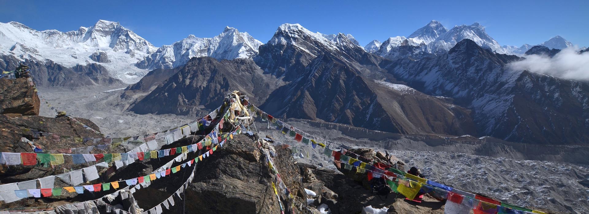
## Trekking and climbing peaks in the Everest area
The Everest region offers a multitude of trekking tours. The Earth’s ‘ceiling’ makes a profound impression on those travelling here. The local landscape is defined by its many 8,000 m peaks – Mount Everest, Lhotse and Makalu in particular- but is also appreciated for aesthetically-pleasing peaks like Ama Dablam and Pumori. Along with the classic expeditions to Everest Base Camp, plenty more trekking summits await, accessible via comfortable to demanding ascents.
[Find your adventure](https://mount-everest3d.com/tours)
## RealityMaps App - Ultra realistic 3D maps for adventurers
## RealityMaps App - Ultra realistic 3D maps for adventurers
Professional mountaineers rely on the photo-realistic, three-dimensional maps of 3D RealityMaps. If you also want to use the unique maps on tour, then download the RealityMaps App now! Get inspired by thousands hiking-, mountain- and bike routes in the Himalaya, the Alps, the Pyrenees and the Canary and Balearic Islands. More information at **[www.realitymaps.app](http://www.realitymaps.app/)**
[](https://apps.apple.com/de/app/mount-everest-3d/id6167043531)
[](https://play.google.com/store/apps/details?id=de.realitymaps.everest&hl=de&gl=US)
3D Reality Maps was single handedly the best part of my expedition for my friends and family back home. With accurate live tracking on great quality 3D maps they could truly feel part of the climb, every step of the way! I had messages from family saying that the 3D Map was the first and last thing they checked everyday as well as being able to zoom in and out and look at the other mountains in the area too

Jon GuptaHigh Altitude
Expedition Leader
Visiting the routes virtually and evaluating options step by step in combination with tour reports was very valuable for my preparation – at the same time, the 3D live tracking made communication a lot easier and helped many people to participate

Jost KobuschAlpinist
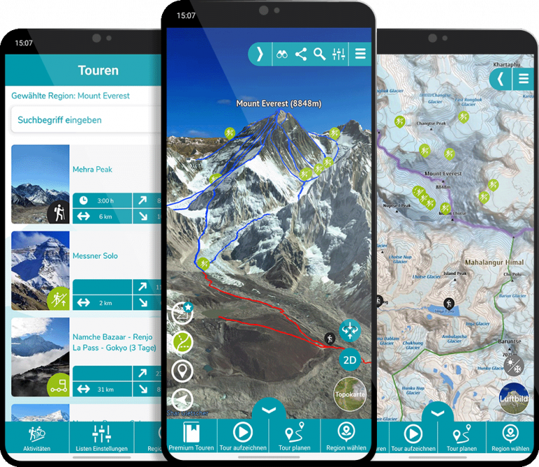
## Unique route planner and GPS navigation tool
The award-winning RealityMaps app is the perfect tool for planning your next outdoor adventure. The **ultra realistic 3D representation of the mountain landscape** allows an intuitive, realistic assessment of the terrain and the technical requirements of a tour.
On the way the digitized landscape is displayed in 3D on your smartphone. **Your current location is shown live on the map**. This this simplifies orientation on the go. You can navigate freely in the map and you can check not yet visible parts of your route. Your planned track and other important information is displayed onscreen.
## Unique route planner and GPS navigation tool
## Unique route planner and GPS navigation tool
The award-winning RealityMaps app is the perfect tool for planning your next outdoor adventure. The **ultra realistic 3D representation of the mountain landscape** allows an intuitive, realistic assessment of the terrain and the technical requirements of a tour.
On the way the digitized landscape is displayed in 3D on your smartphone. **Your current location is shown live on the map**. This this simplifies orientation on the go. You can navigate freely in the map and you can check not yet visible parts of your route. Your planned track and other important information is displayed onscreen.
## GPS tracking
3D RealityMaps GmbH offers GPS tracking services for individuals and expeditions in the Himalaya and especially Khumbu Region of Mount Everest. GPS tracking devices such as Garmin inReach or SPOT devices are supported. GPS positions are instantly displayed in the interactive 3D map. This allows followers, interested parties and family members to follow the progress of the expedition in real-time from home.
#### Contact
- 3D RealityMaps GmbH
Landsberger Str. 314
80687 Munich
\+49 (0)89 74849454
info(@)realitymaps.de
#### About
- [Legal details](https://mount-everest3d.com/imprint)
- [The company](https://www.realitymaps.de/)
#### Links
- [RealityMaps App](https://www.realitymaps.app/)
#### Keep In Touch
[Twitter](https://twitter.com/realitymaps) [Linkedin-in](https://de.linkedin.com/company/3d-realitymaps-gmbh) [Facebook-f](https://www.facebook.com/realitymaps/) [Youtube](https://www.youtube.com/channel/UCHWMvEjw9am-Q20Zc_rA3Uw) [Vimeo](https://vimeo.com/333309267) |
| Readable Markdown | 


Slider 1
3D Map of Mt. Everest & the Himalaya
[\>\> Load 3D Map](https://mount-everest3d.com/3d-map/)


Interactive 3D map of Mount Everest, the Himalaya and popular trekking tours
We created an interactive 3D map of Mount Everest and the Himalaya which is unique in its resolution, unparalleled in detail, and based on the latest satellite technology. The map includes the two most-travelled routes to the highest mountain on Earth, all historical routes and the most famous trekking routes in the Khumbu region. If you plan a trip to Mount Everest, then **[install the RealityMaps app version now](https://mount-everest3d.com/#app)** \!
Video - route to the summit of Mount Everest
Video - route to the summit of Mount Everest
The video shows the route from Lukla through the Khumbu region to the Base Camp of Mount Everest. From there, it leads through the dangerous Khumbu icefall, followed by the glacial valley of the Western Cwm, where Camp 1 and Camp 2 are located. A steep ascent then leads up Lhotse Face to Camp 4 on South Col at roughly 8000 m. On the summit day, climbers need to first need to master the Southeast ridge and Hillary Step, before they finally reach the summit. Find out more about all routes to the roof of the world and its climbing [history](https://mount-everest3d.com/history/).
Trekking and climbing peaks in the Everest area
The Everest region offers a multitude of trekking tours. The Earth’s ‘ceiling’ makes a profound impression on those travelling here. The local landscape is defined by its many 8,000 m peaks – Mount Everest, Lhotse and Makalu in particular- but is also appreciated for aesthetically-pleasing peaks like Ama Dablam and Pumori. Along with the classic expeditions to Everest Base Camp, plenty more trekking summits await, accessible via comfortable to demanding ascents.
[Find your adventure](https://mount-everest3d.com/tours)
RealityMaps App - Ultra realistic 3D maps for adventurers
RealityMaps App - Ultra realistic 3D maps for adventurers
Professional mountaineers rely on the photo-realistic, three-dimensional maps of 3D RealityMaps. If you also want to use the unique maps on tour, then download the RealityMaps App now! Get inspired by thousands hiking-, mountain- and bike routes in the Himalaya, the Alps, the Pyrenees and the Canary and Balearic Islands. More information at **[www.realitymaps.app](http://www.realitymaps.app/)**
[](https://apps.apple.com/de/app/mount-everest-3d/id6167043531)
[](https://play.google.com/store/apps/details?id=de.realitymaps.everest&hl=de&gl=US)

3D Reality Maps was single handedly the best part of my expedition for my friends and family back home. With accurate live tracking on great quality 3D maps they could truly feel part of the climb, every step of the way! I had messages from family saying that the 3D Map was the first and last thing they checked everyday as well as being able to zoom in and out and look at the other mountains in the area too

Jon GuptaHigh Altitude
Expedition Leader
Visiting the routes virtually and evaluating options step by step in combination with tour reports was very valuable for my preparation – at the same time, the 3D live tracking made communication a lot easier and helped many people to participate

Jost KobuschAlpinist
Unique route planner and GPS navigation tool
The award-winning RealityMaps app is the perfect tool for planning your next outdoor adventure. The **ultra realistic 3D representation of the mountain landscape** allows an intuitive, realistic assessment of the terrain and the technical requirements of a tour.
On the way the digitized landscape is displayed in 3D on your smartphone. **Your current location is shown live on the map**. This this simplifies orientation on the go. You can navigate freely in the map and you can check not yet visible parts of your route. Your planned track and other important information is displayed onscreen.
Unique route planner and GPS navigation tool
Unique route planner and GPS navigation tool
The award-winning RealityMaps app is the perfect tool for planning your next outdoor adventure. The **ultra realistic 3D representation of the mountain landscape** allows an intuitive, realistic assessment of the terrain and the technical requirements of a tour.
On the way the digitized landscape is displayed in 3D on your smartphone. **Your current location is shown live on the map**. This this simplifies orientation on the go. You can navigate freely in the map and you can check not yet visible parts of your route. Your planned track and other important information is displayed onscreen.
GPS tracking
3D RealityMaps GmbH offers GPS tracking services for individuals and expeditions in the Himalaya and especially Khumbu Region of Mount Everest. GPS tracking devices such as Garmin inReach or SPOT devices are supported. GPS positions are instantly displayed in the interactive 3D map. This allows followers, interested parties and family members to follow the progress of the expedition in real-time from home. |
| Shard | 41 (laksa) |
| Root Hash | 12369807173382588841 |
| Unparsed URL | com,mount-everest3d!/ s443 |