ℹ️ Skipped - page is already crawled
| Filter | Status | Condition | Details |
|---|---|---|---|
| HTTP status | PASS | download_http_code = 200 | HTTP 200 |
| Age cutoff | PASS | download_stamp > now() - 6 MONTH | 0 months ago |
| History drop | PASS | isNull(history_drop_reason) | No drop reason |
| Spam/ban | PASS | fh_dont_index != 1 AND ml_spam_score = 0 | ml_spam_score=0 |
| Canonical | PASS | meta_canonical IS NULL OR = '' OR = src_unparsed | Not set |
| Property | Value | |||||||||||||||||||||
|---|---|---|---|---|---|---|---|---|---|---|---|---|---|---|---|---|---|---|---|---|---|---|
| URL | https://gohikevirginia.com/hikes-near-richmond-va/ | |||||||||||||||||||||
| Last Crawled | 2026-04-25 09:34:32 (1 day ago) | |||||||||||||||||||||
| First Indexed | 2022-11-30 21:50:56 (3 years ago) | |||||||||||||||||||||
| HTTP Status Code | 200 | |||||||||||||||||||||
| Content | ||||||||||||||||||||||
| Meta Title | 8 Great Hikes Near Richmond, Virginia | |||||||||||||||||||||
| Meta Description | There are lots of nice hikes near Richmond, Virginia, many with forest and river views. You'll even find rock scrambles and water crossings. | |||||||||||||||||||||
| Meta Canonical | null | |||||||||||||||||||||
| Boilerpipe Text | In spite of its urban location, there are a surprising number of very nice hikes in and near Richmond, Virginia, many with forest, pond and river views.
Thanks to the celebrated James River Park System, you’ll find more than 550 acres of public green space across the capital city for outdoor recreation.
Richmond straddles the Fall Line, a 43-mile north-south spine that runs across
Central Virginia
. It’s where the Coastal Plain and Piedmont regions meet.
This means that most hiking trails are rather flat. You won’t find high peaks or much in the way of elevation changes. Nearly all hikes are considered easy.
Ordinarily, I would separate out hikes by difficulty, then by distance from a town landmark. However, every hike except the park loop is an easy hike.
However, I only tagged the
James River Park Loop
as moderate because it has a few more ups and downs, as well as some rock scrambles and water crossings.
Below I’ve sorted the hikes by distance from the Virginia State Capitol, starting with those that are closest to Richmond. Get ready to hit the hiking trails, friends.
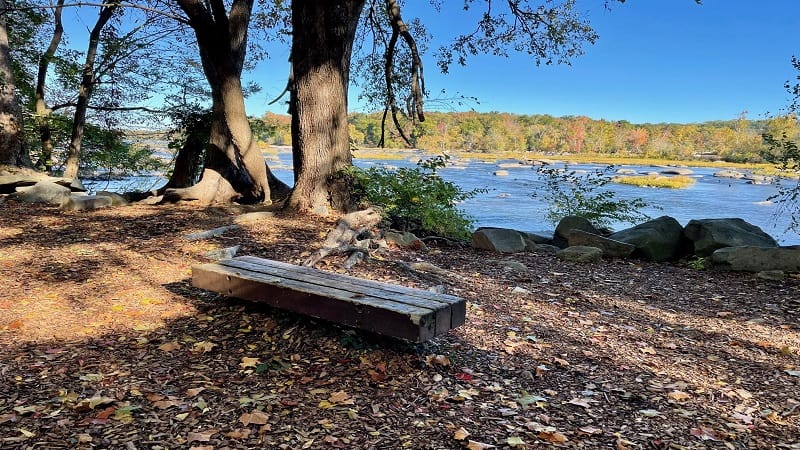
#1:
Belle Isle Trail
(5 mins)
It can be a challenge to find a satisfying hike in an urban setting, but the
Belle Isle Trail
in Richmond’s James River Park goes the extra mile.
This shaded gravel loop trail clocks in at 1.8 miles and engages visitors with historic buildings, rock scrambles, a suspension bridge and river rocks.
In summer, wade and splash in the James River. Keep your eyes open for helmet-clad groups in large inflatable rafts navigating the river rapids.
#2:
Richmond Canal Walk
(5 mins)
The in-town
Richmond Canal Walk
guides you along the James River, as well as the Kanawha Canal and Haxall Canal. I was able to get in 2.8 miles.
There are also colorful murals, including brand-new murals painted on the former hydroelectric plant near 11
th
Street in September 2022.
The open-air site has been home to murals for some time, but new murals were painted during Richmond’s annual
RVA Street Art Festival
.
#3:
Texas Beach
(10 mins)
This forested urban hike begins at the North Bank Entrance of James River Park, guiding hikers to and along the ever-flowing James River.
But first, revel in colorful Texas Beach Murals that first appeared in 2014 as a way to cover up graffiti in the stairwell that crosses over the train tracks.
Nature- and wildlife-themed murals delight day hikers. Continue on for footbridges and dam-created waterfalls before approaching the James River.
#4:
James River Park Loop
(10 mins)
It’s a cinch to piece together the Buttermilk Trail, North Bank Trail and Belle Isle Trail to create a 6.5-mile loop hike at
James River Park
.
Start at Reedy Creek, which can get busy on weekends, then hike clockwise on the Buttermilk Trail. Get ready for rock scrambles and water crossings.
Once you cross the Boulevard Bridge, you’ll pass Maymont, which includes a walk through a bamboo forest. Late in the hike, hopscotch across Dry Rocks.
#5:
Forest Hill Park Trail
(10 mins)
There is a lot of history to the 105-acre Forest Hill Park. The park land has been home to a rock quarry, an amusement park and a trolley line.
The leafy park has a 3.2-mile dirt trail that generally creates a large loop around this urban park. It’s also easy to create your own park loop.
The Forest Hill Park Trail is not well marked. Sticking close to the small lily-pad strewn lake is a good idea. Also, watch for mountain bikers on weekends.
#6:
Larus Park
(15 mins)
Larus Park
is a 106-acre public park nestled between three major roads: Stony Point Parkway, Chippenham Parkway and West Huguenot Road.
There are four wooded trails, known simply as red, green, blue and yellow. The red trail is the longest at 1.08 miles. The .6-mile green trail is the shortest.
It’s easy to create your own hike by cobbling together several different trails. On a recent visit, I found that a 2.7-mile lollipop hike was a good way to go.
#7:
Pony Pasture Rapids Park
(15 mins)
Situated on the flowing James River,
Pony Pasture Rapids Park
is among the most popular public parks within the James River Park System in Richmond.
Here you’ll find several short hiking trails, including the Riverside Trail, Center Trail and Pleasants Creek Trail. You’ll also find picnic tables and restrooms.
It’s a snap to cobble together the park trails to create a 2.3-mile double loop that includes river views and a walk through a quiet wetlands section.
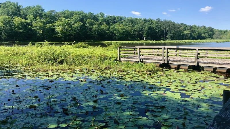
#8:
Beaver Lake Trail
(35 mins)
The walk around Beaver Lake at Pocahontas State Park is a quiet loop with mild terrain and evolving scenery, like wooden boardwalks and bridges.
The views across lily pad-strewn Beaver Lake are serene and delightful. Even better, wooden benches turn up every .5-mile along this shady hiking trail.
Late in the hike, a dam cascades water onto a scenic spillway. This is a wildly popular spot to stop for a snack break or to re-hydrate.
Erin Gifford | |||||||||||||||||||||
| Markdown | [Skip to content](https://gohikevirginia.com/hikes-near-richmond-va/#main)
[](https://gohikevirginia.com/)
### [Go Hike Virginia](https://gohikevirginia.com/ "Go Hike Virginia")
- [Start Here](https://gohikevirginia.com/start-here/)
- [My Books](https://gohikevirginia.com/hiking-books/)
- [How to Leave an Amazon Review](https://gohikevirginia.com/book-reviews-amazon/)
- [Trail Finder](https://gohikevirginia.com/map-of-virginia-hikes/)
- [Best Of Hikes](https://gohikevirginia.com/category/best-of/)
- [Shenandoah National Park](https://gohikevirginia.com/category/shenandoah-national-park/)
[Best Of](https://gohikevirginia.com/category/best-of/)
# 8 Great Hikes Near Richmond, Virginia
[November 30, 2022](https://gohikevirginia.com/hikes-near-richmond-va/ "2:49 pm")
[Erin Gifford](https://gohikevirginia.com/author/erinhike/ "Erin Gifford") [Central Virginia](https://gohikevirginia.com/tag/central-virginia/)
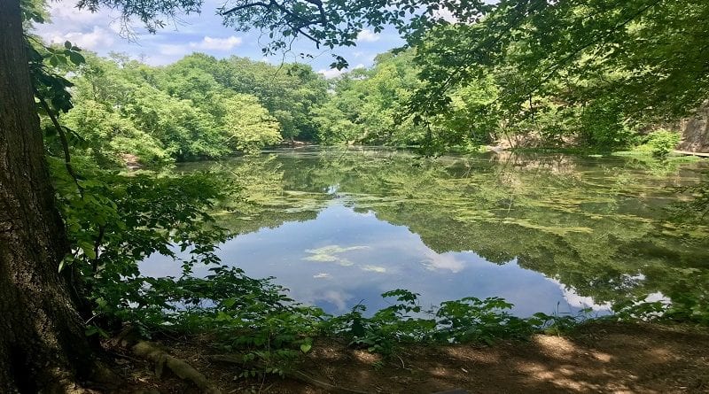
In spite of its urban location, there are a surprising number of very nice hikes in and near Richmond, Virginia, many with forest, pond and river views.
Thanks to the celebrated James River Park System, you’ll find more than 550 acres of public green space across the capital city for outdoor recreation.
Richmond straddles the Fall Line, a 43-mile north-south spine that runs across [Central Virginia](https://gohikevirginia.com/central-virginia-day-hikes/). It’s where the Coastal Plain and Piedmont regions meet.
This means that most hiking trails are rather flat. You won’t find high peaks or much in the way of elevation changes. Nearly all hikes are considered easy.
## **Hiking Near Richmond, Virginia**
Ordinarily, I would separate out hikes by difficulty, then by distance from a town landmark. However, every hike except the park loop is an easy hike.
However, I only tagged the [James River Park Loop](https://gohikevirginia.com/james-river-park-loop/) as moderate because it has a few more ups and downs, as well as some rock scrambles and water crossings.
Below I’ve sorted the hikes by distance from the Virginia State Capitol, starting with those that are closest to Richmond. Get ready to hit the hiking trails, friends.
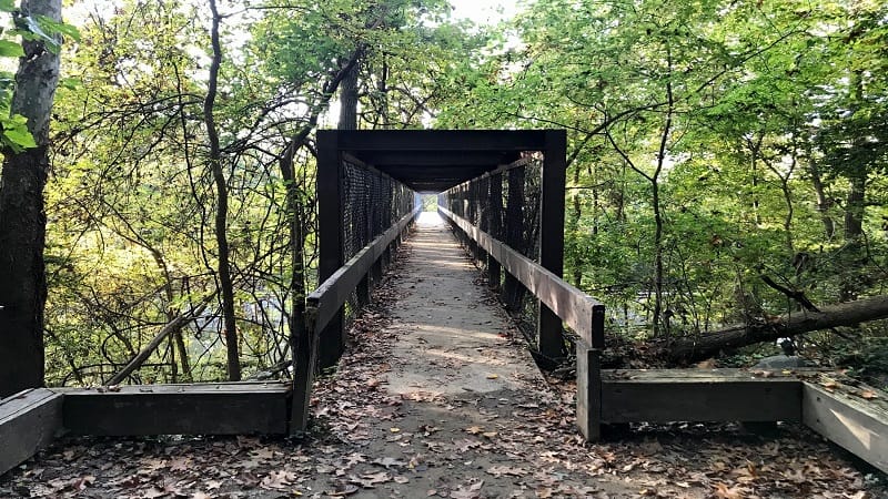
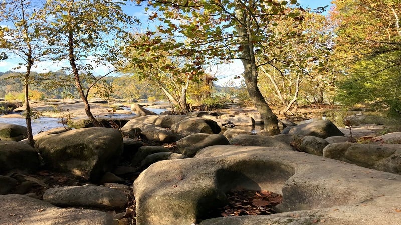
### **\#1: [Belle Isle Trail](https://gohikevirginia.com/belle-isle-trail/) (5 mins)**
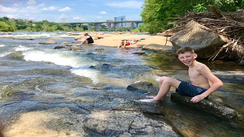
It can be a challenge to find a satisfying hike in an urban setting, but the [Belle Isle Trail](https://gohikevirginia.com/belle-isle-trail/) in Richmond’s James River Park goes the extra mile.
This shaded gravel loop trail clocks in at 1.8 miles and engages visitors with historic buildings, rock scrambles, a suspension bridge and river rocks.
In summer, wade and splash in the James River. Keep your eyes open for helmet-clad groups in large inflatable rafts navigating the river rapids.
### **\#2: [Richmond Canal Walk](https://gohikevirginia.com/richmond-canal-walk/) (5 mins)**
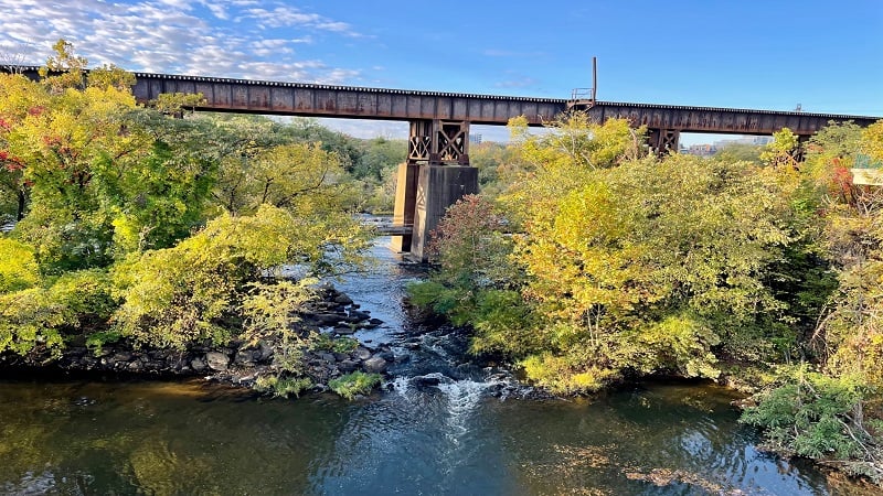
The in-town [Richmond Canal Walk](https://gohikevirginia.com/richmond-canal-walk/) guides you along the James River, as well as the Kanawha Canal and Haxall Canal. I was able to get in 2.8 miles.
There are also colorful murals, including brand-new murals painted on the former hydroelectric plant near 11th Street in September 2022.
The open-air site has been home to murals for some time, but new murals were painted during Richmond’s annual [RVA Street Art Festival](https://www.rvastreetart.com/).
### **\#3: [Texas Beach](https://gohikevirginia.com/texas-beach-trail/) (10 mins)**
This forested urban hike begins at the North Bank Entrance of James River Park, guiding hikers to and along the ever-flowing James River.
But first, revel in colorful Texas Beach Murals that first appeared in 2014 as a way to cover up graffiti in the stairwell that crosses over the train tracks.
Nature- and wildlife-themed murals delight day hikers. Continue on for footbridges and dam-created waterfalls before approaching the James River.
### **\#4: [James River Park Loop](https://gohikevirginia.com/james-river-park-loop/) (10 mins)**
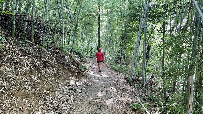
It’s a cinch to piece together the Buttermilk Trail, North Bank Trail and Belle Isle Trail to create a 6.5-mile loop hike at [James River Park](https://gohikevirginia.com/james-river-park-loop/).
Start at Reedy Creek, which can get busy on weekends, then hike clockwise on the Buttermilk Trail. Get ready for rock scrambles and water crossings.
Once you cross the Boulevard Bridge, you’ll pass Maymont, which includes a walk through a bamboo forest. Late in the hike, hopscotch across Dry Rocks.
### **\#5: [Forest Hill Park Trail](https://gohikevirginia.com/forest-hill-park-trail/) (10 mins)**
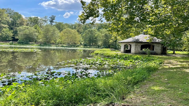
There is a lot of history to the 105-acre Forest Hill Park. The park land has been home to a rock quarry, an amusement park and a trolley line.
The leafy park has a 3.2-mile dirt trail that generally creates a large loop around this urban park. It’s also easy to create your own park loop.
The Forest Hill Park Trail is not well marked. Sticking close to the small lily-pad strewn lake is a good idea. Also, watch for mountain bikers on weekends.
### **\#6: [Larus Park](https://gohikevirginia.com/larus-park/) (15 mins)**
[Larus Park](https://gohikevirginia.com/larus-park/) is a 106-acre public park nestled between three major roads: Stony Point Parkway, Chippenham Parkway and West Huguenot Road.
There are four wooded trails, known simply as red, green, blue and yellow. The red trail is the longest at 1.08 miles. The .6-mile green trail is the shortest.
It’s easy to create your own hike by cobbling together several different trails. On a recent visit, I found that a 2.7-mile lollipop hike was a good way to go.
### **\#7: [Pony Pasture Rapids Park](https://gohikevirginia.com/pony-pasture-trails/) (15 mins)**
Situated on the flowing James River, [Pony Pasture Rapids Park](https://gohikevirginia.com/pony-pasture-trails/) is among the most popular public parks within the James River Park System in Richmond.
Here you’ll find several short hiking trails, including the Riverside Trail, Center Trail and Pleasants Creek Trail. You’ll also find picnic tables and restrooms.
It’s a snap to cobble together the park trails to create a 2.3-mile double loop that includes river views and a walk through a quiet wetlands section.
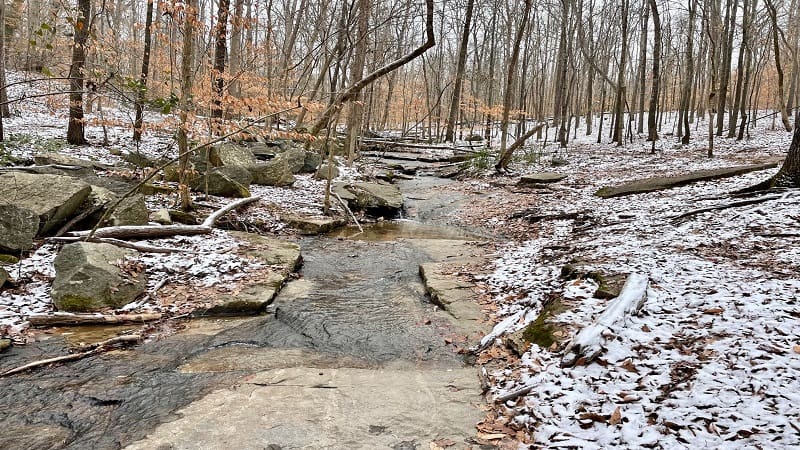
### **\#8: [Beaver Lake Trail](https://gohikevirginia.com/beaver-lake-trail-hike/) (35 mins)**
The walk around Beaver Lake at Pocahontas State Park is a quiet loop with mild terrain and evolving scenery, like wooden boardwalks and bridges.
The views across lily pad-strewn Beaver Lake are serene and delightful. Even better, wooden benches turn up every .5-mile along this shady hiking trail.
Late in the hike, a dam cascades water onto a scenic spillway. This is a wildly popular spot to stop for a snack break or to re-hydrate.
Erin Gifford
[Erin Gifford](https://gohikevirginia.com/start-here/) has completed more than 300 hikes in Virginia. She is also the author of [three hiking guidebooks](https://gohikevirginia.com/hiking-books/) from Falcon Guides. Need help finding a hike? Check out the [Trail Finder](https://gohikevirginia.com/map-of-virginia-hikes/) feature or send Erin an email at [\[email protected\]](https://gohikevirginia.com/cdn-cgi/l/email-protection#016473686f41666e69686a6477687366686f68602f626e6c).
- [← Strickler Knob: An Eye-Pleasing Rock Scramble Hike Near Luray, Virginia](https://gohikevirginia.com/strickler-knob/)
- [Appalachian Trail: Hike to the Manassas Gap Shelter in Linden, Virginia →](https://gohikevirginia.com/manassas-gap-shelter/)
#### You May Also Like
[](https://gohikevirginia.com/central-virginia-day-hikes/ "12 Best Day Hikes in Central Virginia")
### [12 Best Day Hikes in Central Virginia](https://gohikevirginia.com/central-virginia-day-hikes/ "12 Best Day Hikes in Central Virginia")
[April 23, 2021May 26, 2023](https://gohikevirginia.com/central-virginia-day-hikes/ "7:00 am")
[Erin Gifford](https://gohikevirginia.com/author/erinhike/ "Erin Gifford")
[](https://gohikevirginia.com/appalachian-trail-shelters-virginia/ "Gear Up to Hike to These 14 Appalachian Trail Shelters in Virginia")
### [Gear Up to Hike to These 14 Appalachian Trail Shelters in Virginia](https://gohikevirginia.com/appalachian-trail-shelters-virginia/ "Gear Up to Hike to These 14 Appalachian Trail Shelters in Virginia")
[August 31, 2022August 31, 2022](https://gohikevirginia.com/appalachian-trail-shelters-virginia/ "7:00 am")
[Erin Gifford](https://gohikevirginia.com/author/erinhike/ "Erin Gifford")
[](https://gohikevirginia.com/hikes-near-leesburg-va/ "10 Best Hikes Near Leesburg, Virginia")
### [10 Best Hikes Near Leesburg, Virginia](https://gohikevirginia.com/hikes-near-leesburg-va/ "10 Best Hikes Near Leesburg, Virginia")
[January 5, 2022November 26, 2023](https://gohikevirginia.com/hikes-near-leesburg-va/ "7:00 am")
[Erin Gifford](https://gohikevirginia.com/author/erinhike/ "Erin Gifford")
### SEARCH
*As an Amazon Associate I earn from qualifying purchases.*
Copyright © 2026 [Go Hike Virginia](https://gohikevirginia.com/ "Go Hike Virginia"). All rights reserved.
Theme: [ColorMag](https://themegrill.com/themes/colormag "ColorMag") by ThemeGrill. Powered by [WordPress](https://wordpress.org/ "WordPress").
This website uses cookies to improve your experience. We'll assume you're ok with this, but you can opt-out if you wish.[Accept]() [Read More](https://gohikevirginia.com/privacy-cookies-policy/)
Privacy & Cookies Policy
Close
#### Privacy Overview
This website uses cookies to improve your experience while you navigate through the website. Out of these, the cookies that are categorized as necessary are stored on your browser as they are essential for the working of basic functionalities of the website. We also use third-party cookies that help us analyze and understand how you use this website. These cookies will be stored in your browser only with your consent. You also have the option to opt-out of these cookies. But opting out of some of these cookies may affect your browsing experience.
[Necessary]()
Necessary
Always Enabled
Necessary cookies are absolutely essential for the website to function properly. These cookies ensure basic functionalities and security features of the website, anonymously.
| Cookie | Duration | Description |
|---|---|---|
| cookielawinfo-checkbox-analytics | 11 months | This cookie is set by GDPR Cookie Consent plugin. The cookie is used to store the user consent for the cookies in the category "Analytics". |
| cookielawinfo-checkbox-functional | 11 months | The cookie is set by GDPR cookie consent to record the user consent for the cookies in the category "Functional". |
| cookielawinfo-checkbox-necessary | 11 months | This cookie is set by GDPR Cookie Consent plugin. The cookies is used to store the user consent for the cookies in the category "Necessary". |
| cookielawinfo-checkbox-others | 11 months | This cookie is set by GDPR Cookie Consent plugin. The cookie is used to store the user consent for the cookies in the category "Other. |
| cookielawinfo-checkbox-performance | 11 months | This cookie is set by GDPR Cookie Consent plugin. The cookie is used to store the user consent for the cookies in the category "Performance". |
| viewed\_cookie\_policy | 11 months | The cookie is set by the GDPR Cookie Consent plugin and is used to store whether or not user has consented to the use of cookies. It does not store any personal data. |
[Functional]()
Functional
Functional cookies help to perform certain functionalities like sharing the content of the website on social media platforms, collect feedbacks, and other third-party features.
[Performance]()
Performance
Performance cookies are used to understand and analyze the key performance indexes of the website which helps in delivering a better user experience for the visitors.
[Analytics]()
Analytics
Analytical cookies are used to understand how visitors interact with the website. These cookies help provide information on metrics the number of visitors, bounce rate, traffic source, etc.
[Advertisement]()
Advertisement
Advertisement cookies are used to provide visitors with relevant ads and marketing campaigns. These cookies track visitors across websites and collect information to provide customized ads.
[Others]()
Others
Other uncategorized cookies are those that are being analyzed and have not been classified into a category as yet.
[SAVE & ACCEPT]() | |||||||||||||||||||||
| Readable Markdown | In spite of its urban location, there are a surprising number of very nice hikes in and near Richmond, Virginia, many with forest, pond and river views.
Thanks to the celebrated James River Park System, you’ll find more than 550 acres of public green space across the capital city for outdoor recreation.

Richmond straddles the Fall Line, a 43-mile north-south spine that runs across [Central Virginia](https://gohikevirginia.com/central-virginia-day-hikes/). It’s where the Coastal Plain and Piedmont regions meet.
This means that most hiking trails are rather flat. You won’t find high peaks or much in the way of elevation changes. Nearly all hikes are considered easy.
Ordinarily, I would separate out hikes by difficulty, then by distance from a town landmark. However, every hike except the park loop is an easy hike.
However, I only tagged the [James River Park Loop](https://gohikevirginia.com/james-river-park-loop/) as moderate because it has a few more ups and downs, as well as some rock scrambles and water crossings.
Below I’ve sorted the hikes by distance from the Virginia State Capitol, starting with those that are closest to Richmond. Get ready to hit the hiking trails, friends.
### **\#1: [Belle Isle Trail](https://gohikevirginia.com/belle-isle-trail/) (5 mins)**

It can be a challenge to find a satisfying hike in an urban setting, but the [Belle Isle Trail](https://gohikevirginia.com/belle-isle-trail/) in Richmond’s James River Park goes the extra mile.
This shaded gravel loop trail clocks in at 1.8 miles and engages visitors with historic buildings, rock scrambles, a suspension bridge and river rocks.
In summer, wade and splash in the James River. Keep your eyes open for helmet-clad groups in large inflatable rafts navigating the river rapids.
### **\#2: [Richmond Canal Walk](https://gohikevirginia.com/richmond-canal-walk/) (5 mins)**

The in-town [Richmond Canal Walk](https://gohikevirginia.com/richmond-canal-walk/) guides you along the James River, as well as the Kanawha Canal and Haxall Canal. I was able to get in 2.8 miles.
There are also colorful murals, including brand-new murals painted on the former hydroelectric plant near 11th Street in September 2022.
The open-air site has been home to murals for some time, but new murals were painted during Richmond’s annual [RVA Street Art Festival](https://www.rvastreetart.com/).
### **\#3: [Texas Beach](https://gohikevirginia.com/texas-beach-trail/) (10 mins)**

This forested urban hike begins at the North Bank Entrance of James River Park, guiding hikers to and along the ever-flowing James River.
But first, revel in colorful Texas Beach Murals that first appeared in 2014 as a way to cover up graffiti in the stairwell that crosses over the train tracks.
Nature- and wildlife-themed murals delight day hikers. Continue on for footbridges and dam-created waterfalls before approaching the James River.
### **\#4: [James River Park Loop](https://gohikevirginia.com/james-river-park-loop/) (10 mins)**

It’s a cinch to piece together the Buttermilk Trail, North Bank Trail and Belle Isle Trail to create a 6.5-mile loop hike at [James River Park](https://gohikevirginia.com/james-river-park-loop/).
Start at Reedy Creek, which can get busy on weekends, then hike clockwise on the Buttermilk Trail. Get ready for rock scrambles and water crossings.
Once you cross the Boulevard Bridge, you’ll pass Maymont, which includes a walk through a bamboo forest. Late in the hike, hopscotch across Dry Rocks.
### **\#5: [Forest Hill Park Trail](https://gohikevirginia.com/forest-hill-park-trail/) (10 mins)**

There is a lot of history to the 105-acre Forest Hill Park. The park land has been home to a rock quarry, an amusement park and a trolley line.
The leafy park has a 3.2-mile dirt trail that generally creates a large loop around this urban park. It’s also easy to create your own park loop.
The Forest Hill Park Trail is not well marked. Sticking close to the small lily-pad strewn lake is a good idea. Also, watch for mountain bikers on weekends.
### **\#6: [Larus Park](https://gohikevirginia.com/larus-park/) (15 mins)**

[Larus Park](https://gohikevirginia.com/larus-park/) is a 106-acre public park nestled between three major roads: Stony Point Parkway, Chippenham Parkway and West Huguenot Road.
There are four wooded trails, known simply as red, green, blue and yellow. The red trail is the longest at 1.08 miles. The .6-mile green trail is the shortest.
It’s easy to create your own hike by cobbling together several different trails. On a recent visit, I found that a 2.7-mile lollipop hike was a good way to go.
### **\#7: [Pony Pasture Rapids Park](https://gohikevirginia.com/pony-pasture-trails/) (15 mins)**

Situated on the flowing James River, [Pony Pasture Rapids Park](https://gohikevirginia.com/pony-pasture-trails/) is among the most popular public parks within the James River Park System in Richmond.
Here you’ll find several short hiking trails, including the Riverside Trail, Center Trail and Pleasants Creek Trail. You’ll also find picnic tables and restrooms.
It’s a snap to cobble together the park trails to create a 2.3-mile double loop that includes river views and a walk through a quiet wetlands section.
### **\#8: [Beaver Lake Trail](https://gohikevirginia.com/beaver-lake-trail-hike/) (35 mins)**

The walk around Beaver Lake at Pocahontas State Park is a quiet loop with mild terrain and evolving scenery, like wooden boardwalks and bridges.
The views across lily pad-strewn Beaver Lake are serene and delightful. Even better, wooden benches turn up every .5-mile along this shady hiking trail.
Late in the hike, a dam cascades water onto a scenic spillway. This is a wildly popular spot to stop for a snack break or to re-hydrate.

Erin Gifford | |||||||||||||||||||||
| ML Classification | ||||||||||||||||||||||
| ML Categories |
Raw JSON{
"/Hobbies_and_Leisure": 838,
"/Hobbies_and_Leisure/Outdoors": 838,
"/Hobbies_and_Leisure/Outdoors/Hiking_and_Camping": 835,
"/Sports": 156,
"/Sports/Individual_Sports": 150,
"/Sports/Individual_Sports/Running_and_Walking": 135,
"/Travel_and_Transportation": 108
} | |||||||||||||||||||||
| ML Page Types |
Raw JSON{
"/Article": 822,
"/Article/Roundup": 604
} | |||||||||||||||||||||
| ML Intent Types |
Raw JSON{
"Informational": 999
} | |||||||||||||||||||||
| Content Metadata | ||||||||||||||||||||||
| Language | en-us | |||||||||||||||||||||
| Author | Erin Gifford | |||||||||||||||||||||
| Publish Time | 2022-11-30 19:49:52 (3 years ago) | |||||||||||||||||||||
| Original Publish Time | 2022-11-30 19:49:52 (3 years ago) | |||||||||||||||||||||
| Republished | No | |||||||||||||||||||||
| Word Count (Total) | 1,507 | |||||||||||||||||||||
| Word Count (Content) | 850 | |||||||||||||||||||||
| Links | ||||||||||||||||||||||
| External Links | 6 | |||||||||||||||||||||
| Internal Links | 27 | |||||||||||||||||||||
| Technical SEO | ||||||||||||||||||||||
| Meta Nofollow | No | |||||||||||||||||||||
| Meta Noarchive | No | |||||||||||||||||||||
| JS Rendered | No | |||||||||||||||||||||
| Redirect Target | null | |||||||||||||||||||||
| Performance | ||||||||||||||||||||||
| Download Time (ms) | 120 | |||||||||||||||||||||
| TTFB (ms) | 97 | |||||||||||||||||||||
| Download Size (bytes) | 30,027 | |||||||||||||||||||||
| Shard | 99 (laksa) | |||||||||||||||||||||
| Root Hash | 8546664982564277699 | |||||||||||||||||||||
| Unparsed URL | com,gohikevirginia!/hikes-near-richmond-va/ s443 | |||||||||||||||||||||