ℹ️ Skipped - page is already crawled
| Filter | Status | Condition | Details |
|---|---|---|---|
| HTTP status | PASS | download_http_code = 200 | HTTP 200 |
| Age cutoff | PASS | download_stamp > now() - 6 MONTH | 0.3 months ago |
| History drop | PASS | isNull(history_drop_reason) | No drop reason |
| Spam/ban | PASS | fh_dont_index != 1 AND ml_spam_score = 0 | ml_spam_score=0 |
| Canonical | PASS | meta_canonical IS NULL OR = '' OR = src_unparsed | Not set |
| Property | Value |
|---|---|
| URL | https://en.wikivoyage.org/wiki/Everest_Base_Camp_Trek |
| Last Crawled | 2026-04-02 15:58:04 (8 days ago) |
| First Indexed | 2015-04-25 06:39:00 (10 years ago) |
| HTTP Status Code | 200 |
| Meta Title | Everest Base Camp Trek – Travel guide at Wikivoyage |
| Meta Description | null |
| Meta Canonical | null |
| Boilerpipe Text | See
Qomolangma
for routes to the Tibetan Everest Base Camp on the north side.
Everest Base Camp Trek
is a famous and moderately challenging trek in
Khumbu
,
Nepal
.
Mount Everest (centre left) from KalaPatthar with the Khumbu glacier below it and base camp just below that
Famous for its spectacular mountain peaks and the loyalty of the Sherpa people, the Khumbu region offers a deep cultural experience alongside its iconic scenery. Most Sherpas under 50 speak at least basic English, making it easy to navigate by simply asking locals for directions. While the trek does not require technical climbing skills, it demands high physical fitness for arduous mountain routes and a commitment to slow acclimatization to avoid altitude sickness.
You can hire a horse to carry you out in case of injury.
Pack animals on the way to Everest
As of
2026
, the "No Guide, No Trek" rule is strictly enforced within the Sagarmatha National Park. Trekkers must be accompanied by a government-licensed guide and possess a valid
E-TIMS digital QR code
registered through an authorized agency. These are verified alongside local permits at the
Monjo and Lukla checkpoints
. These are strictly checked at Monjo and Lukla/Toktok; failure to present them results in denied entry or fines. Bring sufficient cash in Nepalese Rupees, as local businesses do not accept foreign currency or cards. A reasonable daily budget is Rs. 3,500–4,500 per person, though costs rise significantly with altitude. Other essential preparations include booking the weather-dependent flight to Lukla and acquiring layered clothing. Comprehensive insurance covering high-altitude helicopter evacuation is mandatory.
While not mandatory, hiring guides or porters as support provides flexibility and local income. Porters (Rs. 2,500–4,500/day) carry your gear, while guides (higher, negotiated rates) manage the route and safety but do not carry bags. Most guides are Sherpa or Tamang, while porters are often Rai. It is safer to hire through lodge owners (e.g., at Eco Paradise in Lukla or Namche Hotel) rather than aggressive airport touts. Ensure terms are clear: you must generally provide meals for staff above Namche due to high food costs.
You do not need to carry a stove or heavy food supplies, as the route is dotted with tea houses offering ready meals. Food prices generally range from Rs. 700 to 1,500 per meal. While you are well-fed between trekking segments, remember that prices increase the higher you trek.
Do not drink untreated water, no matter how pristine it appears. Use iodine tablets for purification or purchase boiled water. While locals in Namche and Phortse drink directly from taps, outsiders should avoid this due to a lack of immunity, though it is generally acceptable for brushing teeth. Clean water is also available for purchase at lodges and cafés, with bottled water costing Rs. 250–450.
There is no need for a tent, as a network of lodges provides shelter. Basic rooms cost between Rs. 700 and 1,200. Be aware that amenities often cost extra: a hot shower runs Rs. 400–800, and battery charging is roughly Rs. 100–300 per hour. Conditions are basic; lodges above
Tengboche
often close in winter, and those open are very cold, necessitating a high-quality sleeping bag.
Trekking is possible year-round, but March to mid-May and September to mid-November are ideal. Spring offers blooming rhododendrons but can be dusty, while autumn provides the clearest views after the monsoon rains. Winters are harsh with deep snow often blocking paths above
Tengboche
, and summers are characterized by heavy rain and clouds that obscure the mountain peaks.
Fly to
27.6875
86.731389
1
Lukla airport
(
LUA
IATA
) from
Kathmandu
(
KTM
IATA
). There are several airlines operating dozens of flights every day. Tara Air is generally considered the most reliable. Sita Air also operates two flights every morning from Kathmandu to Lukla at 07:00 and 08:20. The flight takes around 25 minutes. During the summer rainy season, there may be substantial delays, even a wait of a week is not unheard of. For the return journey, the flights leave Lukla at 07:40 and 09:00. Helicopter charter service is also available on demand and is mostly used for rescue operations. Be aware that airline safety regulations in Nepal are poor, and as a result the country has more than its fair share of plane crashes.
Alternatives are to fly to
Phaplu
airport, which has been pushed the last few years, in part due to renovations at KTM, 2-3
trekking
days south of
Lukla
, or to walk in from
Jiri
, which is 5-7 trekking days west of Lukla. These alternatives take more time and therefore are less popular, but are very peaceful and pleasant, and safer than flying into Lukla.
Wikimedia
Mapnik
Relief map
Traffic line network
Cycling
Hiking
city
go
see
vicinity
10 km
Map of Everest Base Camp Trek
One of many suspension bridges on the way to Everest
The trail of the Everest Trek
Way to Namche
Short Rest point on Everest Base Trail
Everest Basecamp (Nepalese side) as seen from the Khumbu Icefall
Everest Base Trek Route Map, not to scale
Khumbu
is an area for trekking. The trek can be as short as a two day walk from
Lukla
to
Namche Bazaar
or an eight to ten day trip to Everest Base Camp. Irrespective of the length of the journey, as there are no roads in the area, it will definitely involve putting on hiking boots and walking the mountain paths. Below is an itinerary from Lukla Airport to Everest Base Camp and all points in between.
Lukla airport to Monju
6 mi
6.5 hr
Starting from Lukla airport, pass directly through the village of
Lukla
(there is no compelling reason to stop here, though it is a good place to have breakfast or lunch) and follow the path to Namche. There will no doubt be a string of porters carrying goods up to the Sherpa capital, so the route is easy to locate. The first village after Lukla is Chheplung, and further down the trail, you will pass through
Ghat
and
Phakding
. Both these villages have a good selection of lodges and restaurants and are conveniently located for taking a meal break. However, if you still have enough stamina, it is advisable to press on to
27.772222
86.722778
1
Monju
, at
2,800
m (9,200
ft)
and about 1.5 to 2 hr from Phakding, to spend the night as this will give you a good start for the steep ascent to Namche the following morning.
Monju to Namche
3 mi
3–4 hr
Namche Bazaar Nepal
After passing through the Sagarmatha Park entrance (3,390 Rs for foreigners), the trail passes through the village of
Jorsale
and then along the river. You will cross two bridges before beginning the steep ascent to
Namche
, which can take up to 3 hr to complete. Be aware that there are no tea houses or lodges on this path, so ensure that you have ample water to get you to the top. In addition, you are now heading into a high altitude area, so take it easy. Even the fittest people are prone to
altitude sickness
. Namche sits at around
3,440
m (11,290
ft)
, and it is recommended to take an altitude acclimatisation rest day in Namche. Although no more than a village, the Sherpa capital has two museums, several internet cafes, and, at last count, two pizza parlours and three cafes (locally known as bakeries), so there is much to keep you occupied during your stay here. Namche also has two official money changers, so it is a good place to stock up on local currency for the days ahead (lodges and restaurants in Khumbu only accept Nepali rupees). There is also a reasonable selection of English books, though the prices are higher than in Kathmandu. Namche has a post office, but there are mixed reports of letters reaching their destinations. Postage stamps are also available in local shops. Namche is also a good spot to pick up Everest Link Wi-Fi cards.
A solar cooker in Tengboche, a town on the Everest trek
During your acclimatisation rest day, you might like to visit neighbouring villages.
27.82386
86.71745
1
Khumjung
(3790m) is over the hill directly behind Namche, and takes 1.5–2 hr to reach. There are several sights in the village (See listings below) and a few lodges and cafes. Khunde is a short walk from
Khumjung
. To get there, take the Tengboche trail, then at the top of the hill above Namche, near the huge mani stone and just past the bank, head straight up the mountain; the wider path to the right goes to
Tengboche
. After a steep climb, you will arrive at an airstrip. Cross this and rejoin the path at the other side. After a short distance you'll pass a stupa. From there, take the paved path down the hill. Soon you will see the playground and school buildings of Khumjung Hillary School.
27.83
86.65
2
Thame
at
3,750
m (12,300
ft)
, is a more traditional village that is about a 2.5–3 hr walk from Namche.
To get there, leave Namche on the path that passes the ochre coloured Namche Monastery (Namche Gompa). From here, it is a relatively flat walk that takes in some very pleasant scenery. The first hamlet on the route is Phurte, identified by the forest nursery, and then Tesho. The water that runs through Tesho comes directly from Mount Khumbi Yui Lha, the most sacred mountain to the Sherpas, so there are several retreat huts built into the niches. Thame is the next village on the trail, and a good place to take lunch. Thame has a few lodges and is home to one of Khumbu's oldest monasteries. This trail was also a traditional route to Tibet; however, the border crossing has been closed for at least 20 years.
Ama Dablam
mountain as seen on the trek into Everest base camp
Namche to Tengboche
3 mi
5–6 hr
After a short but steep climb out of Namche Bazaar, then walk on a fairly level trail to the villages of Kenjuma and Sanasa. Here there are extensive displays of souvenirs to tempt you and food and drinks. The Ama Dablam Lodge in Kanjuma has some good food and the sitting area out front offers uninhibited views of Ama Dablam. In addition, the lodge reputedly has the best selection of jewellery for sale in Khumbu, so if you don't plan to return this way, pick out a few light souvenirs; they will forever remind you of this sun-blessed place and the sparkling snow capped peak of Ama Dablam. After a short while, the trail descends to the level of the Dudh Koshi River, and you will pass a few hamlets and cross several bridges.
Then at the hamlet of Phunki Thanga (marked by its water driven prayer wheels), the trail ascends steeply. There are no tea houses or lodges on this stretch, so take some refreshment in Phunki Thanga and stock up on water for the 1.5–2 hr climb to
27.836
86.763944
2
Tengboche
, at
3,870
m (12,700
ft)
. Take it easy going up here. The air is thinner than you are aware! You want to avoid mountain sickness.
Tengboche to Periche
6 mi
5–6 hr
Day six
: For those heading for
Everest
, the trail passes through the villages of
Deboche
(here, there is a small nunnery on the left - definitely worth a visit),
27.856389
86.789722
3
Pangboche
at
3,860
m (12,660
ft)
,
27.8919
86.8297
4
Dingboche
and finally
27.893561
86.819876
5
Periche
at
4,240
m (13,910
ft)
. All these villages offer food and lodgings. Pangboche (especially Upper-Pangboche, where the local monastery is located) is, however, probably the most pleasant as it is surrounded by trees. So, if you decide to take the journey slowly, this is the best place to rest and relax. For those heading for
Island Peak Trek
or the Lhotse Glacier, your final destination will be
Chukhung
. As this is further than Periche, you will definitely need to stop the night in Pangboche or Dingboche.
In Periche, you will need to take a day to acclimatise to the high altitude. Take short, slow walks around the village, marvel at the peaks and dig out the book you bought in Namche, but whatever you do, don't push it at this point. If you begin to feel unwell, inform your guide or lodge owner and return as quickly as possible to a lower altitude. The experts say hike high sleep low. So some Nepal experts recommend that if you are feeling well, to hike each day to a higher elevation than you will sleep.
Periche to Lobuche
5 mi
4–6 hr
Spend the night in
27.948056
86.810278
6
Lobuche
, at
4,930
m (16,170
ft)
, a small village packed with tourists. There are several lodges at this village but not much to do here besides eat and sleep. Often trekkers entering Lobuche will find the lodges full and may have to share a room with a stranger or sleep in the common room. Even if you have a room, you may be asked by the lodge owner to share it with someone.
Lobuche to Gorak Shep
3 mi
3 hr
You can take a short side-trip and visit the Everest Pyramid, a weather station built by Italians. In
27.980978
86.828556
7
Gorak Shep
, at
5,160
m (16,930
ft)
, there is a small, usually frozen lake. This village now has three lodges: Himalaya Lodge, Snowland Lodge and the Kala Pattar lodge. Gorak Shep will be your base to visit the
28.00722
86.85944
3
Everest Base Camp
at
5,380
m (17,650
ft)
and to climb the hill behind the lodges called
27.995833
86.828417
4
Kala Patthar
at
5,643
m (18,514
ft)
with great views of
27.988056
86.925
1
MISSING WIKILINK
Mt. Everest
and surrounding mountains.
27.925
86.833333
2
Pokalde
, at
5,806
m (19,049
ft)
is described as one of the shortest and easiest trekking peaks in the Everest Region, and can be a compelling side trip option. You can also take an alternate return trip from Lobuche by taking the trail via the pass
27.961725
86.751637
3
MISSING WIKILINK
Cho La
at
5,370
m (17,620
ft)
to the wonderful
27.954088
86.694588
8
Gokyo
valley with its glacier lakes and fine views offers some stunning scenery and is not as crowded as that to
Everest
.
Icicles at Everest Base Camp
WARNING:
Climbing to the top of Mount Everest is an
extremely dangerous
endeavour, even for experienced mountaineers led by guides and using supplemental (bottled) oxygen. Inexperienced climbers should not even think about attempting it, and deaths and serious injuries to experienced climbers, including guides and Sherpas, are common. If you decide you want to attempt the summit anyway,
always follow your guide's instructions
. Failing to do so can easily cause serious permanent injury or even death.
Mount Everest is the highest mountain in the world, at
8,848
m (29,029
ft)
. Its alternate names are Qomolangma, Sagarmatha, and Chomolungma. Mount Everest lies on the border of Nepal and China, with about half of the mountain lying on each side of the border. Sir Edmund Hillary and Tenzing Norgay first climbed it in 1953, with Hillary taking the famous photograph of Tenzing Norgay on the summit.
There are several bodies still lying on the upper portions of the mountain above the South Col on the Nepal side and the North East ridge on the Tibetan side. The Governments of Nepal and China require all prospective climbers to purchase a permit. The fees depend on the route and season of the climb. A standard Nepali permit is $USD 50,000 for 7 climbers. There are also additional bonds to ensure refuse is removed from the mountain.
There are two main routes, Southeast and Northeast, for climbing Mt. Everest. Southeast is the most frequently-used route because it is generally considered safer and has easier access.
The ascent via the southeast ridge begins with a trek to Base Camp at
5,380
m (17,650
ft)
on the south side of Everest in Nepal. Expedition members usually fly into Lukla, which sits at
2,860
m (9,380
ft)
, from Kathmandu and pass through Namche Bazaar. Climbers then hike to Base Camp, which usually takes six to eight days, allowing for proper altitude acclimatisation in order to prevent altitude sickness. Climbing equipment and supplies are carried by yaks, dzopkyos (yak hybrids) and human porters to Base Camp on the Khumbu Glacier.
When
Hillary and Tenzing
climbed Everest in 1953, they started from Kathmandu Valley, as there were no roads further east at that time.
Everest Base Camp
At Everest Base Camp, climbers will often spend 4–8 weeks, acclimatising to the altitude. During that time, the "Icefall Doctors" will set up ropes and ladders in the notoriously unstable Khumbu Icefall. Seracs, crevasses and shifting blocks of ice make the icefall one of the most dangerous sections of the route. Many climbers and Sherpas have been killed in this section. To reduce the risk, climbers will usually begin their ascent well before sunrise when the freezing temperatures glue ice blocks in place. Above the icefall is Camp I at
6,065
m (19,898
ft)
. It's mostly a temporary camp with most climbers just spending one night there.
Camp II
Base Camp II, Advanced Base Camp (ABC) is established at
6,400
m (21,000
ft)
. The Western Cwm is a relatively flat, gently rising glacial valley, marked by huge lateral crevasses in the centre which prevent direct access to the upper reaches of the Cwm. Climbers are forced to cross on the far right near the base of Nuptse to a small passageway known as the "Nuptse corner". The Western Cwm as the topography of the area generally cuts off wind from the climbing route. The high altitude and a clear, windless day can make the Western Cwm unbearably hot for climbers.
Camp III
From ABC, climbers ascend the Lhotse face on set ropes up to Camp III, situated on small ledges at approximately 7,200 m to 7,400 m. From there, it is another 500 metres to Camp IV on the South Col at
7,920
m (25,980
ft)
. From Camp III to Camp IV, mountaineers are faced with two additional obstacles: The “Geneva Spur” and The “Yellow Band”. The Geneva Spur is an anvil shaped rib of black rock named by a 1952 Swiss expedition. Fixed ropes help climbers to scramble over this snow covered rock band. The Yellow Band is a section of sedimentary sandstone. The route from the base of the Lhotse face to the Summit is almost always completely fixed with static line.
On the South Col, climbers are very close to
8,000
m (26,000
ft)
and can only spend limited time at those altitudes even with supplemental oxygen. Climbers typically only have a maximum of two or three days they can tolerate at this altitude for making peak bids. Clear weather and low winds are important factors when deciding on a summit attempt. If weather does not cooperate within these short few days, climbers are forced to move down, many all the way back to Base Camp.
Camp IV
From Camp IV, mountaineers will start their summit push from 20:00 to 02:00 with the hope of reaching the summit (still another
1,000
m (3,300
ft)
above) within 10 to 12 hr. Climbers will first reach "The Balcony" at
8,400
m (27,600
ft)
, a small platform where they can rest and gaze at peaks to the south and east in the early dawn light. Continuing up the ridge, climbers are then faced with a series of impressive rock steps which usually force them to the east into waist deep snow. At
8,750
m (28,710
ft)
, a small table-sized area of ice and snow marks the South Summit (Peak).
From the South Peak, climbers ascend the knife-edge southeast ridge, known as the "Cornice traverse" where snow covers irregular rock. This is the most exposed part of the climb, as a misstep to the left would send one
2,400
m (7,900
ft)
down the southwest face, while to the immediate right is the
3,050
m (10,010
ft)
Kangshung face. At the end of this traverse is an imposing 12 m (40 ft) rock wall called the "Hillary Step" at
8,760
m (28,740
ft)
.
Tenzing and Hillary were the first mountaineers to rise to this step and they did it with early ice climbing equipment and without fixed ropes. Now, climbers will ascend this step using fixed ropes previously set up by Sherpas. Once above the step, it is a comparatively easy climb to the top on fairly angled snow slopes, although the exposure on the ridge is extreme, especially while traversing very large cornices of snow. After the Hillary Step climbers also must traverse a very loose and rocky section that has a very large entanglement of fixed ropes that can be troublesome in bad weather. Climbers will typically spend less than a half-hour on "top of the world" as they realise the need to descend to Camp IV before darkness sets in, afternoon weather becomes a serious problem, or supplemental oxygen tanks run out.
Water Driven Prayer Wheel at Phungi Tanga
Altitude sickness
is the primary risk; it affects everyone regardless of age or fitness. If you experience dizziness, palpitations, or severe headaches, descend immediately. For medical support, the Kunde Clinic (above Namche) features a decompression chamber, while the Himalayan Rescue Association in Pheriche offers daily health lectures and oxygen checks for Rs. 100. Emergency-only centers exist in Machhermo, and basic medical stations are scattered along the trail for minor ailments like cuts.
On the trails, always yield to yaks and pack animals by standing on the upper slope (away from the cliff edge), as they can accidentally push trekkers off the path. Regarding security, keep valuables in sight to prevent opportunistic theft and be wary of helicopter evacuation scams where operators may try to overcharge or pressure you into unnecessary flights.
If the Everest trek has you hooked on the Himalayas, several other world-class treks offer different challenges and scenery.
Annapurna Circuit
– Nepal's other classic teahouse trek. It offers greater cultural and landscape diversity than the Everest region, circling the entire Annapurna massif and crossing the high Thorong La pass at 5,416 m.
Gokyo Lakes Trek – For a greater challenge within the Everest region itself, this trek explores the valley of stunning turquoise glacial lakes. The truly ambitious can link the Everest and Gokyo valleys via the Three Passes Trek, a strenuous route for experienced trekkers.
Langtang Valley Trek
– A great alternative if you are looking for fewer crowds. This trek is more accessible from Kathmandu and offers beautiful forests, traditional Tamang culture, and close-up views of the Langtang Lirung glacier.
Tackle a Trekking Peak – For a taste of real mountaineering, consider climbing a trekking peak. Island Peak (Imja Tse) is a popular next step after EBC, offering a challenging but achievable climb to over 6,100 m for a true summit experience.
This
itinerary
to
Everest Base Camp Trek
is a
usable
article. It explains how to get there and touches on all the major points along the way. An adventurous person could use this article, but please
feel free to improve
it
by editing the page
. |
| Markdown | [Jump to content](https://en.wikivoyage.org/wiki/Everest_Base_Camp_Trek#bodyContent)
Main menu
Main menu
move to sidebar
hide
Navigation
- [Main page](https://en.wikivoyage.org/wiki/Main_Page)
- [Travel destinations](https://en.wikivoyage.org/wiki/Destinations)
- [Star articles](https://en.wikivoyage.org/wiki/Star_articles)
- [What's nearby?](https://en.wikivoyage.org/wiki/Special:Nearby)
- [Travel forum](https://en.wikivoyage.org/wiki/Wikivoyage:Travel_forum)
- [Arrivals lounge](https://en.wikivoyage.org/wiki/Wikivoyage:Arrivals_lounge)
- [Random page](https://en.wikivoyage.org/wiki/Special:Random "Load a random page [alt-x]")
Get involved
- [Travellers' pub](https://en.wikivoyage.org/wiki/Wikivoyage:Travellers%27_pub)
- [Recent changes](https://en.wikivoyage.org/wiki/Special:RecentChanges "A list of recent changes in the wiki [alt-r]")
- [Community portal](https://en.wikivoyage.org/wiki/Wikivoyage:Community_portal "About the project, what you can do, where to find things")
- [Maintenance panel](https://en.wikivoyage.org/wiki/Wikivoyage:Maintenance_panel)
- [Policies](https://en.wikivoyage.org/wiki/Wikivoyage:Policies)
- [Help](https://en.wikivoyage.org/wiki/Wikivoyage:Help "The place to find out")
- [Interlingual lounge](https://meta.wikimedia.org/wiki/Wikivoyage/Lounge)
[ ](https://en.wikivoyage.org/wiki/Main_Page)
[Search](https://en.wikivoyage.org/wiki/Special:Search "Search Wikivoyage [alt-f]")
Appearance
Appearance
move to sidebar
hide
Text
This page always uses small font size
Width
The content is as wide as possible for your browser window.
Color (beta)
This page is always in light mode.
- [Donate](https://donate.wikimedia.org/?wmf_source=donate&wmf_medium=sidebar&wmf_campaign=en.wikivoyage.org&uselang=en)
- [Create account](https://en.wikivoyage.org/w/index.php?title=Special:CreateAccount&returnto=Everest+Base+Camp+Trek "You are encouraged to create an account and log in; however, it is not mandatory")
- [Log in](https://en.wikivoyage.org/w/index.php?title=Special:UserLogin&returnto=Everest+Base+Camp+Trek "You are encouraged to log in; however, it is not mandatory [alt-o]")
Personal tools
- [Donate](https://donate.wikimedia.org/?wmf_source=donate&wmf_medium=sidebar&wmf_campaign=en.wikivoyage.org&uselang=en)
- [Create account](https://en.wikivoyage.org/w/index.php?title=Special:CreateAccount&returnto=Everest+Base+Camp+Trek "You are encouraged to create an account and log in; however, it is not mandatory")
- [Log in](https://en.wikivoyage.org/w/index.php?title=Special:UserLogin&returnto=Everest+Base+Camp+Trek "You are encouraged to log in; however, it is not mandatory [alt-o]")
\[[dismiss]()\]
Join us at the [travel forum](https://en.wikivoyage.org/wiki/Wikivoyage:Travel_forum "Wikivoyage:Travel forum"), where you can share your upcoming travel plans, travel experiences or discuss anything about travel.
Toggle the table of contents
## Contents
move to sidebar
hide
- [Beginning](https://en.wikivoyage.org/wiki/Everest_Base_Camp_Trek)
- [1 Understand](https://en.wikivoyage.org/wiki/Everest_Base_Camp_Trek#Understand)
- [2 Prepare](https://en.wikivoyage.org/wiki/Everest_Base_Camp_Trek#Prepare)
Toggle Prepare subsection
- [2\.1 Eat](https://en.wikivoyage.org/wiki/Everest_Base_Camp_Trek#Eat)
- [2\.2 Drink](https://en.wikivoyage.org/wiki/Everest_Base_Camp_Trek#Drink)
- [2\.3 Sleep](https://en.wikivoyage.org/wiki/Everest_Base_Camp_Trek#Sleep)
- [2\.4 Climate](https://en.wikivoyage.org/wiki/Everest_Base_Camp_Trek#Climate)
- [3 Get in](https://en.wikivoyage.org/wiki/Everest_Base_Camp_Trek#Get_in)
- [4 Walk](https://en.wikivoyage.org/wiki/Everest_Base_Camp_Trek#Walk)
Toggle Walk subsection
- [4\.1 Mount Everest](https://en.wikivoyage.org/wiki/Everest_Base_Camp_Trek#Mount_Everest)
- [5 Stay safe](https://en.wikivoyage.org/wiki/Everest_Base_Camp_Trek#Stay_safe)
- [6 Go next](https://en.wikivoyage.org/wiki/Everest_Base_Camp_Trek#Go_next)
#
4 languages
- [বাংলা](https://bn.wikivoyage.org/wiki/%E0%A6%8F%E0%A6%AD%E0%A6%BE%E0%A6%B0%E0%A7%87%E0%A6%B8%E0%A7%8D%E0%A6%9F_%E0%A6%AC%E0%A7%87%E0%A6%B8_%E0%A6%95%E0%A7%8D%E0%A6%AF%E0%A6%BE%E0%A6%AE%E0%A7%8D%E0%A6%AA_%E0%A6%9F%E0%A7%8D%E0%A6%B0%E0%A7%87%E0%A6%95 "এভারেস্ট বেস ক্যাম্প ট্রেক – Bangla")
- [Deutsch](https://de.wikivoyage.org/wiki/Everest_Basecamp_Trek "Everest Basecamp Trek – German")
- [עברית](https://he.wikivoyage.org/wiki/%D7%98%D7%A8%D7%A7_%D7%90%D7%9C_%D7%9E%D7%97%D7%A0%D7%94_%D7%94%D7%91%D7%A1%D7%99%D7%A1_%D7%94%D7%93%D7%A8%D7%95%D7%9E%D7%99_%D7%A9%D7%9C_%D7%94%D7%A8_%D7%90%D7%95%D7%95%D7%A8%D7%A1%D7%98 "טרק אל מחנה הבסיס הדרומי של הר אוורסט – Hebrew")
- [Italiano](https://it.wikivoyage.org/wiki/Trekking_al_Campo_Base_dell%27Everest "Trekking al Campo Base dell'Everest – Italian")
[Edit links](https://www.wikidata.org/wiki/Special:EntityPage/Q1950455#sitelinks-wikivoyage "Edit interlanguage links")
- [Page](https://en.wikivoyage.org/wiki/Everest_Base_Camp_Trek "View the content page [alt-c]")
- [Discussion](https://en.wikivoyage.org/wiki/Talk:Everest_Base_Camp_Trek "Discussion about the content page [alt-t]")
English
- [Read](https://en.wikivoyage.org/wiki/Everest_Base_Camp_Trek)
- [Edit](https://en.wikivoyage.org/w/index.php?title=Everest_Base_Camp_Trek&action=edit "Edit the source code of this page [alt-e]")
- [View history](https://en.wikivoyage.org/w/index.php?title=Everest_Base_Camp_Trek&action=history "Past revisions of this page [alt-h]")
Tools
Tools
move to sidebar
hide
Actions
- [Read](https://en.wikivoyage.org/wiki/Everest_Base_Camp_Trek)
- [Edit](https://en.wikivoyage.org/w/index.php?title=Everest_Base_Camp_Trek&action=edit "Edit the source code of this page [alt-e]")
- [View history](https://en.wikivoyage.org/w/index.php?title=Everest_Base_Camp_Trek&action=history)
General
- [What links here](https://en.wikivoyage.org/wiki/Special:WhatLinksHere/Everest_Base_Camp_Trek "A list of all wiki pages that link here [alt-j]")
- [Related changes](https://en.wikivoyage.org/wiki/Special:RecentChangesLinked/Everest_Base_Camp_Trek "Recent changes in pages linked from this page [alt-k]")
- [Upload file](https://en.wikivoyage.org/wiki/Wikivoyage:Upload_file "Upload files [alt-u]")
- [Permanent link](https://en.wikivoyage.org/w/index.php?title=Everest_Base_Camp_Trek&oldid=5232847 "Permanent link to this revision of this page")
- [Page information](https://en.wikivoyage.org/w/index.php?title=Everest_Base_Camp_Trek&action=info "More information about this page")
- [Cite this page](https://en.wikivoyage.org/w/index.php?title=Special:CiteThisPage&page=Everest_Base_Camp_Trek&id=5232847&wpFormIdentifier=titleform "Information on how to cite this page")
- [Get shortened URL](https://en.wikivoyage.org/w/index.php?title=Special:UrlShortener&url=https%3A%2F%2Fen.wikivoyage.org%2Fwiki%2FEverest_Base_Camp_Trek)
- [Switch to legacy parser](https://en.wikivoyage.org/w/index.php?title=Everest_Base_Camp_Trek&useparsoid=0)
- [Edit interlanguage links](https://www.wikidata.org/wiki/Special:EntityPage/Q1950455#sitelinks-wikivoyage "Edit interlanguage links")
Print/export
- [Create a book](https://en.wikivoyage.org/w/index.php?title=Special:Book&bookcmd=book_creator&referer=Everest+Base+Camp+Trek)
- [Download as PDF](https://en.wikivoyage.org/w/index.php?title=Special:DownloadAsPdf&page=Everest_Base_Camp_Trek&action=show-download-screen)
- [Printable version](https://en.wikivoyage.org/w/index.php?title=Everest_Base_Camp_Trek&printable=yes "Printable version of this page [alt-p]")
In other projects
- [Wikimedia Commons](https://commons.wikimedia.org/wiki/Category:Sagarmatha_Trek)
- [Wikidata item](https://www.wikidata.org/wiki/Special:EntityPage/Q1950455 "Link to connected data repository item [alt-g]")
[](https://tools.wmflabs.org/wikivoyage/w/poi2gpx.php?print=gpx&lang=en&name=Everest_Base_Camp_Trek "Download GPX file for this article")
From Wikivoyage
[Itineraries](https://en.wikivoyage.org/wiki/Itineraries "Itineraries")
\>
[Asia itineraries](https://en.wikivoyage.org/wiki/Asia_itineraries "Asia itineraries")
\>
[South Asia itineraries](https://en.wikivoyage.org/wiki/South_Asia_itineraries "South Asia itineraries")
\>
Everest Base Camp Trek
# Everest Base Camp Trek
[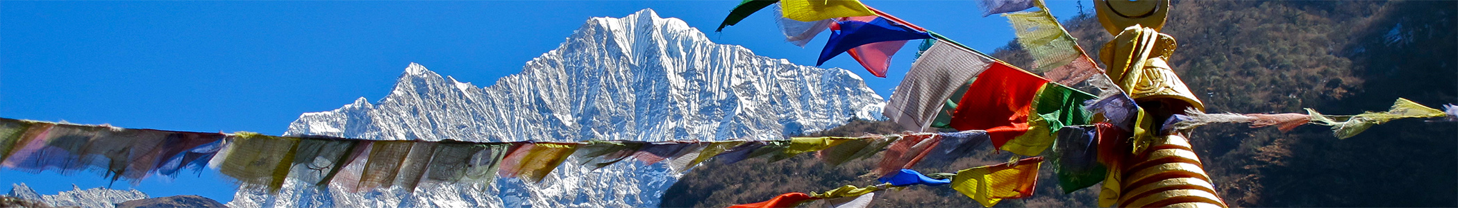](https://en.wikivoyage.org/wiki/File:Everest_Base_Camp_Trek_banne.jpg "Everest Base Camp Trek") [For Sale](https://en.wikivoyage.org/wiki/World_Sale "Click here for the World Sale")
## Contents
- [1 Understand](https://en.wikivoyage.org/wiki/Everest_Base_Camp_Trek#Understand)
- [2 Prepare](https://en.wikivoyage.org/wiki/Everest_Base_Camp_Trek#Prepare)
- [2\.1 Eat](https://en.wikivoyage.org/wiki/Everest_Base_Camp_Trek#Eat)
- [2\.2 Drink](https://en.wikivoyage.org/wiki/Everest_Base_Camp_Trek#Drink)
- [2\.3 Sleep](https://en.wikivoyage.org/wiki/Everest_Base_Camp_Trek#Sleep)
- [2\.4 Climate](https://en.wikivoyage.org/wiki/Everest_Base_Camp_Trek#Climate)
- [3 Get in](https://en.wikivoyage.org/wiki/Everest_Base_Camp_Trek#Get_in)
- [4 Walk](https://en.wikivoyage.org/wiki/Everest_Base_Camp_Trek#Walk)
- [4\.1 Mount Everest](https://en.wikivoyage.org/wiki/Everest_Base_Camp_Trek#Mount_Everest)
- [5 Stay safe](https://en.wikivoyage.org/wiki/Everest_Base_Camp_Trek#Stay_safe)
- [6 Go next](https://en.wikivoyage.org/wiki/Everest_Base_Camp_Trek#Go_next)
See [Qomolangma](https://en.wikivoyage.org/wiki/Qomolangma "Qomolangma") for routes to the Tibetan Everest Base Camp on the north side.
**Everest Base Camp Trek** is a famous and moderately challenging trek in [Khumbu](https://en.wikivoyage.org/wiki/Khumbu "Khumbu"), [Nepal](https://en.wikivoyage.org/wiki/Nepal "Nepal").
## Understand
\[[edit source](https://en.wikivoyage.org/w/index.php?title=Everest_Base_Camp_Trek&action=edit§ion=1 "Edit section's source code: Understand")\]
See also: [Trekking in Nepal](https://en.wikivoyage.org/wiki/Trekking_in_Nepal "Trekking in Nepal")
[](https://en.wikivoyage.org/wiki/File:Everest_from_Khala_Phthar.JPG)
Mount Everest (centre left) from KalaPatthar with the Khumbu glacier below it and base camp just below that
Famous for its spectacular mountain peaks and the loyalty of the Sherpa people, the Khumbu region offers a deep cultural experience alongside its iconic scenery. Most Sherpas under 50 speak at least basic English, making it easy to navigate by simply asking locals for directions. While the trek does not require technical climbing skills, it demands high physical fitness for arduous mountain routes and a commitment to slow acclimatization to avoid altitude sickness.
## Prepare
\[[edit source](https://en.wikivoyage.org/w/index.php?title=Everest_Base_Camp_Trek&action=edit§ion=2 "Edit section's source code: Prepare")\]
[](https://en.wikivoyage.org/wiki/File:HorseEverest.JPG)
You can hire a horse to carry you out in case of injury.
[](https://en.wikivoyage.org/wiki/File:PackanimalsEverest.JPG)
Pack animals on the way to Everest
As of **2026**, the "No Guide, No Trek" rule is strictly enforced within the Sagarmatha National Park. Trekkers must be accompanied by a government-licensed guide and possess a valid **E-TIMS digital QR code** registered through an authorized agency. These are verified alongside local permits at the **Monjo and Lukla checkpoints**. These are strictly checked at Monjo and Lukla/Toktok; failure to present them results in denied entry or fines. Bring sufficient cash in Nepalese Rupees, as local businesses do not accept foreign currency or cards. A reasonable daily budget is Rs. 3,500–4,500 per person, though costs rise significantly with altitude. Other essential preparations include booking the weather-dependent flight to Lukla and acquiring layered clothing. Comprehensive insurance covering high-altitude helicopter evacuation is mandatory.
While not mandatory, hiring guides or porters as support provides flexibility and local income. Porters (Rs. 2,500–4,500/day) carry your gear, while guides (higher, negotiated rates) manage the route and safety but do not carry bags. Most guides are Sherpa or Tamang, while porters are often Rai. It is safer to hire through lodge owners (e.g., at Eco Paradise in Lukla or Namche Hotel) rather than aggressive airport touts. Ensure terms are clear: you must generally provide meals for staff above Namche due to high food costs.
### Eat
\[[edit source](https://en.wikivoyage.org/w/index.php?title=Everest_Base_Camp_Trek&action=edit§ion=3 "Edit section's source code: Eat")\]
You do not need to carry a stove or heavy food supplies, as the route is dotted with tea houses offering ready meals. Food prices generally range from Rs. 700 to 1,500 per meal. While you are well-fed between trekking segments, remember that prices increase the higher you trek.
### Drink
\[[edit source](https://en.wikivoyage.org/w/index.php?title=Everest_Base_Camp_Trek&action=edit§ion=4 "Edit section's source code: Drink")\]
Do not drink untreated water, no matter how pristine it appears. Use iodine tablets for purification or purchase boiled water. While locals in Namche and Phortse drink directly from taps, outsiders should avoid this due to a lack of immunity, though it is generally acceptable for brushing teeth. Clean water is also available for purchase at lodges and cafés, with bottled water costing Rs. 250–450.
### Sleep
\[[edit source](https://en.wikivoyage.org/w/index.php?title=Everest_Base_Camp_Trek&action=edit§ion=5 "Edit section's source code: Sleep")\]
There is no need for a tent, as a network of lodges provides shelter. Basic rooms cost between Rs. 700 and 1,200. Be aware that amenities often cost extra: a hot shower runs Rs. 400–800, and battery charging is roughly Rs. 100–300 per hour. Conditions are basic; lodges above [Tengboche](https://en.wikivoyage.org/wiki/Tengboche "Tengboche") often close in winter, and those open are very cold, necessitating a high-quality sleeping bag.
### Climate
\[[edit source](https://en.wikivoyage.org/w/index.php?title=Everest_Base_Camp_Trek&action=edit§ion=6 "Edit section's source code: Climate")\]
Trekking is possible year-round, but March to mid-May and September to mid-November are ideal. Spring offers blooming rhododendrons but can be dusty, while autumn provides the clearest views after the monsoon rains. Winters are harsh with deep snow often blocking paths above [Tengboche](https://en.wikivoyage.org/wiki/Tengboche "Tengboche"), and summers are characterized by heavy rain and clouds that obscure the mountain peaks.
## Get in
\[[edit source](https://en.wikivoyage.org/w/index.php?title=Everest_Base_Camp_Trek&action=edit§ion=7 "Edit section's source code: Get in")\][add listing]()
Fly to 27\.6875 86\.731389 [1](https://en.wikivoyage.org/wiki/Everest_Base_Camp_Trek#/maplink/0) Lukla airport [](https://en.wikivoyage.org/wiki/w:Tenzing-Hillary_Airport "Tenzing-Hillary Airport on Wikipedia") (**[LUA](https://en.wikivoyage.org/wiki/Lukla#By_plane "Lukla")**[IATA](https://en.wikivoyage.org/wiki/IATA "IATA")) from [Kathmandu](https://en.wikivoyage.org/wiki/Kathmandu "Kathmandu") (**[KTM](https://en.wikivoyage.org/wiki/Kathmandu#By_plane "Kathmandu")**[IATA](https://en.wikivoyage.org/wiki/IATA "IATA")). There are several airlines operating dozens of flights every day. Tara Air is generally considered the most reliable. Sita Air also operates two flights every morning from Kathmandu to Lukla at 07:00 and 08:20. The flight takes around 25 minutes. During the summer rainy season, there may be substantial delays, even a wait of a week is not unheard of. For the return journey, the flights leave Lukla at 07:40 and 09:00. Helicopter charter service is also available on demand and is mostly used for rescue operations. Be aware that airline safety regulations in Nepal are poor, and as a result the country has more than its fair share of plane crashes.
Alternatives are to fly to [Phaplu](https://en.wikivoyage.org/wiki/Phaplu?action=edit&redlink=1 "Phaplu (page does not exist)") airport, which has been pushed the last few years, in part due to renovations at KTM, 2-3 [trekking](https://nepaltrekkingroutes.com/) days south of [Lukla](https://en.wikivoyage.org/wiki/Lukla "Lukla"), or to walk in from [Jiri](https://en.wikivoyage.org/wiki/Jiri "Jiri"), which is 5-7 trekking days west of Lukla. These alternatives take more time and therefore are less popular, but are very peaceful and pleasant, and safer than flying into Lukla.
## Walk
\[[edit source](https://en.wikivoyage.org/w/index.php?title=Everest_Base_Camp_Trek&action=edit§ion=8 "Edit section's source code: Walk")\]
[ ]()
[\+](https://en.wikivoyage.org/wiki/Everest_Base_Camp_Trek "Zoom in")[−](https://en.wikivoyage.org/wiki/Everest_Base_Camp_Trek "Zoom out")
Wikimedia 
Mapnik
Relief map
Traffic line network
Cycling
Hiking
city
go
see
vicinity
10 km
5 mi
[Wikimedia maps](https://foundation.wikimedia.org/wiki/Maps_Terms_of_Use) \| Map data © [OpenStreetMap contributors](https://www.openstreetmap.org/copyright)
Map of Everest Base Camp Trek
[](https://en.wikivoyage.org/wiki/File:EverestBridge.JPG)
One of many suspension bridges on the way to Everest
[](https://en.wikivoyage.org/wiki/File:TrailCondition.JPG)
The trail of the Everest Trek
[](https://en.wikivoyage.org/wiki/File:Way_to_Namche.jpg)
Way to Namche
[](https://en.wikivoyage.org/wiki/File:Short_Rest_on_Everest_Base_Trail.jpg)
Short Rest point on Everest Base Trail
[](https://en.wikivoyage.org/wiki/File:Everest-BC-North.jpg)
Everest Basecamp (Nepalese side) as seen from the Khumbu Icefall
[](https://en.wikivoyage.org/wiki/File:Everest_Base_Trek_Route_Map.svg)
Everest Base Trek Route Map, not to scale
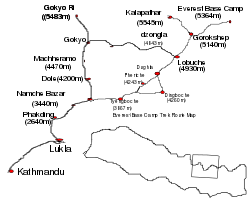
[Khumbu](https://en.wikivoyage.org/wiki/Khumbu "Khumbu") is an area for trekking. The trek can be as short as a two day walk from [Lukla](https://en.wikivoyage.org/wiki/Lukla "Lukla") to [Namche Bazaar](https://en.wikivoyage.org/wiki/Namche_Bazaar "Namche Bazaar") or an eight to ten day trip to Everest Base Camp. Irrespective of the length of the journey, as there are no roads in the area, it will definitely involve putting on hiking boots and walking the mountain paths. Below is an itinerary from Lukla Airport to Everest Base Camp and all points in between.
Lukla airport to Monju
 6 mi 6\.5 hr
Starting from Lukla airport, pass directly through the village of [Lukla](https://en.wikivoyage.org/wiki/Lukla "Lukla") (there is no compelling reason to stop here, though it is a good place to have breakfast or lunch) and follow the path to Namche. There will no doubt be a string of porters carrying goods up to the Sherpa capital, so the route is easy to locate. The first village after Lukla is Chheplung, and further down the trail, you will pass through **[Ghat](https://en.wikivoyage.org/wiki/Ghat_\(Nepal\) "Ghat (Nepal)")** and **[Phakding](https://en.wikivoyage.org/wiki/Phakding?action=edit&redlink=1 "Phakding (page does not exist)")**. Both these villages have a good selection of lodges and restaurants and are conveniently located for taking a meal break. However, if you still have enough stamina, it is advisable to press on to 27\.772222 86\.722778 [1](https://en.wikivoyage.org/wiki/Everest_Base_Camp_Trek#/maplink/5) [Monju](https://en.wikivoyage.org/wiki/Monju "Monju"), at 2,800 m (9,200 ft) and about 1.5 to 2 hr from Phakding, to spend the night as this will give you a good start for the steep ascent to Namche the following morning.
Monju to Namche
 3 mi 3–4 hr
[](https://en.wikivoyage.org/wiki/File:Namche_Bazaar_Nepal.jpg)
Namche Bazaar Nepal
After passing through the Sagarmatha Park entrance (3,390 Rs for foreigners), the trail passes through the village of **[Jorsale](https://en.wikivoyage.org/wiki/Jorsale?action=edit&redlink=1 "Jorsale (page does not exist)")** and then along the river. You will cross two bridges before beginning the steep ascent to [Namche](https://en.wikivoyage.org/wiki/Namche "Namche"), which can take up to 3 hr to complete. Be aware that there are no tea houses or lodges on this path, so ensure that you have ample water to get you to the top. In addition, you are now heading into a high altitude area, so take it easy. Even the fittest people are prone to **[altitude sickness](https://en.wikivoyage.org/wiki/Altitude_sickness "Altitude sickness")**. Namche sits at around 3,440 m (11,290 ft), and it is recommended to take an altitude acclimatisation rest day in Namche. Although no more than a village, the Sherpa capital has two museums, several internet cafes, and, at last count, two pizza parlours and three cafes (locally known as bakeries), so there is much to keep you occupied during your stay here. Namche also has two official money changers, so it is a good place to stock up on local currency for the days ahead (lodges and restaurants in Khumbu only accept Nepali rupees). There is also a reasonable selection of English books, though the prices are higher than in Kathmandu. Namche has a post office, but there are mixed reports of letters reaching their destinations. Postage stamps are also available in local shops. Namche is also a good spot to pick up Everest Link Wi-Fi cards.
[](https://en.wikivoyage.org/wiki/File:SolarCookerEverest.JPG)
A solar cooker in Tengboche, a town on the Everest trek
During your acclimatisation rest day, you might like to visit neighbouring villages. 27\.82386 86\.71745 [1](https://en.wikivoyage.org/wiki/Everest_Base_Camp_Trek#/maplink/6) [Khumjung](https://en.wikivoyage.org/wiki/Khumjung "Khumjung") (3790m) is over the hill directly behind Namche, and takes 1.5–2 hr to reach. There are several sights in the village (See listings below) and a few lodges and cafes. Khunde is a short walk from [Khumjung](https://en.wikivoyage.org/wiki/Khumjung "Khumjung"). To get there, take the Tengboche trail, then at the top of the hill above Namche, near the huge mani stone and just past the bank, head straight up the mountain; the wider path to the right goes to [Tengboche](https://en.wikivoyage.org/wiki/Tengboche "Tengboche"). After a steep climb, you will arrive at an airstrip. Cross this and rejoin the path at the other side. After a short distance you'll pass a stupa. From there, take the paved path down the hill. Soon you will see the playground and school buildings of Khumjung Hillary School. 27\.83 86\.65 [2](https://en.wikivoyage.org/wiki/Everest_Base_Camp_Trek#/maplink/7) [Thame](https://en.wikivoyage.org/wiki/Thame_\(Nepal\) "Thame (Nepal)") at 3,750 m (12,300 ft), is a more traditional village that is about a 2.5–3 hr walk from Namche.
To get there, leave Namche on the path that passes the ochre coloured Namche Monastery (Namche Gompa). From here, it is a relatively flat walk that takes in some very pleasant scenery. The first hamlet on the route is Phurte, identified by the forest nursery, and then Tesho. The water that runs through Tesho comes directly from Mount Khumbi Yui Lha, the most sacred mountain to the Sherpas, so there are several retreat huts built into the niches. Thame is the next village on the trail, and a good place to take lunch. Thame has a few lodges and is home to one of Khumbu's oldest monasteries. This trail was also a traditional route to Tibet; however, the border crossing has been closed for at least 20 years.
[](https://en.wikivoyage.org/wiki/File:AmaDabEvertTrek.JPG)
[Ama Dablam](https://en.wikivoyage.org/wiki/Ama_Dablam?action=edit&redlink=1 "Ama Dablam (page does not exist)") mountain as seen on the trek into Everest base camp
Namche to Tengboche
 3 mi 5–6 hr
After a short but steep climb out of Namche Bazaar, then walk on a fairly level trail to the villages of Kenjuma and Sanasa. Here there are extensive displays of souvenirs to tempt you and food and drinks. The Ama Dablam Lodge in Kanjuma has some good food and the sitting area out front offers uninhibited views of Ama Dablam. In addition, the lodge reputedly has the best selection of jewellery for sale in Khumbu, so if you don't plan to return this way, pick out a few light souvenirs; they will forever remind you of this sun-blessed place and the sparkling snow capped peak of Ama Dablam. After a short while, the trail descends to the level of the Dudh Koshi River, and you will pass a few hamlets and cross several bridges.
Then at the hamlet of Phunki Thanga (marked by its water driven prayer wheels), the trail ascends steeply. There are no tea houses or lodges on this stretch, so take some refreshment in Phunki Thanga and stock up on water for the 1.5–2 hr climb to 27\.836 86\.763944 [2](https://en.wikivoyage.org/wiki/Everest_Base_Camp_Trek#/maplink/8) [Tengboche](https://en.wikivoyage.org/wiki/Tengboche "Tengboche"), at 3,870 m (12,700 ft). Take it easy going up here. The air is thinner than you are aware! You want to avoid mountain sickness.
Tengboche to Periche
 6 mi 5–6 hr
**Day six**: For those heading for **Everest**, the trail passes through the villages of **[Deboche](https://en.wikivoyage.org/wiki/Deboche "Deboche")** (here, there is a small nunnery on the left - definitely worth a visit), 27\.856389 86\.789722 [3](https://en.wikivoyage.org/wiki/Everest_Base_Camp_Trek#/maplink/9) [Pangboche](https://en.wikivoyage.org/wiki/Pangboche "Pangboche") at 3,860 m (12,660 ft), 27\.8919 86\.8297 [4](https://en.wikivoyage.org/wiki/Everest_Base_Camp_Trek#/maplink/10) [Dingboche](https://en.wikivoyage.org/wiki/Dingboche "Dingboche") and finally 27\.893561 86\.819876 [5](https://en.wikivoyage.org/wiki/Everest_Base_Camp_Trek#/maplink/11) [Periche](https://en.wikivoyage.org/wiki/Periche "Periche") at 4,240 m (13,910 ft). All these villages offer food and lodgings. Pangboche (especially Upper-Pangboche, where the local monastery is located) is, however, probably the most pleasant as it is surrounded by trees. So, if you decide to take the journey slowly, this is the best place to rest and relax. For those heading for [Island Peak Trek](https://en.wikivoyage.org/wiki/Island_Peak_Trek "Island Peak Trek") or the Lhotse Glacier, your final destination will be **[Chukhung](https://en.wikivoyage.org/wiki/Chukhung "Chukhung")**. As this is further than Periche, you will definitely need to stop the night in Pangboche or Dingboche.
In Periche, you will need to take a day to acclimatise to the high altitude. Take short, slow walks around the village, marvel at the peaks and dig out the book you bought in Namche, but whatever you do, don't push it at this point. If you begin to feel unwell, inform your guide or lodge owner and return as quickly as possible to a lower altitude. The experts say hike high sleep low. So some Nepal experts recommend that if you are feeling well, to hike each day to a higher elevation than you will sleep.
Periche to Lobuche
 5 mi 4–6 hr
Spend the night in 27\.948056 86\.810278 [6](https://en.wikivoyage.org/wiki/Everest_Base_Camp_Trek#/maplink/12) Lobuche [](https://en.wikivoyage.org/wiki/w:Lobuche,_Nepal "Lobuche, Nepal on Wikipedia"), at 4,930 m (16,170 ft), a small village packed with tourists. There are several lodges at this village but not much to do here besides eat and sleep. Often trekkers entering Lobuche will find the lodges full and may have to share a room with a stranger or sleep in the common room. Even if you have a room, you may be asked by the lodge owner to share it with someone.
Lobuche to Gorak Shep
 3 mi 3 hr
You can take a short side-trip and visit the Everest Pyramid, a weather station built by Italians. In 27\.980978 86\.828556 [7](https://en.wikivoyage.org/wiki/Everest_Base_Camp_Trek#/maplink/13) Gorak Shep [](https://en.wikivoyage.org/wiki/w:Gorakshep "Gorakshep on Wikipedia"), at 5,160 m (16,930 ft), there is a small, usually frozen lake. This village now has three lodges: Himalaya Lodge, Snowland Lodge and the Kala Pattar lodge. Gorak Shep will be your base to visit the 28\.00722 86\.85944 [3](https://en.wikivoyage.org/wiki/Everest_Base_Camp_Trek#/maplink/14) Everest Base Camp at 5,380 m (17,650 ft) and to climb the hill behind the lodges called 27\.995833 86\.828417 [4](https://en.wikivoyage.org/wiki/Everest_Base_Camp_Trek#/maplink/15) Kala Patthar [](https://en.wikivoyage.org/wiki/w:Kala_Patthar "Kala Patthar on Wikipedia") at 5,643 m (18,514 ft) with great views of 27\.988056 86\.925 [1](https://en.wikivoyage.org/wiki/Everest_Base_Camp_Trek#/maplink/16)MISSING WIKILINK Mt. Everest and surrounding mountains.
27\.925 86\.833333 [2](https://en.wikivoyage.org/wiki/Everest_Base_Camp_Trek#/maplink/17) Pokalde [](https://en.wikivoyage.org/wiki/w:Pokalde "Pokalde on Wikipedia"), at 5,806 m (19,049 ft) is described as one of the shortest and easiest trekking peaks in the Everest Region, and can be a compelling side trip option. You can also take an alternate return trip from Lobuche by taking the trail via the pass 27\.961725 86\.751637 [3](https://en.wikivoyage.org/wiki/Everest_Base_Camp_Trek#/maplink/18)MISSING WIKILINK Cho La at 5,370 m (17,620 ft) to the wonderful 27\.954088 86\.694588 [8](https://en.wikivoyage.org/wiki/Everest_Base_Camp_Trek#/maplink/19) [Gokyo](https://en.wikivoyage.org/wiki/Gokyo "Gokyo") valley with its glacier lakes and fine views offers some stunning scenery and is not as crowded as that to **Everest**.
### Mount Everest
\[[edit source](https://en.wikivoyage.org/w/index.php?title=Everest_Base_Camp_Trek&action=edit§ion=9 "Edit section's source code: Mount Everest")\]
[](https://en.wikivoyage.org/wiki/File:Icicles_Formation_at_Everest_Base_Camp.jpg)
Icicles at Everest Base Camp
| | |
|---|---|
|  | **WARNING:** Climbing to the top of Mount Everest is an **extremely dangerous** endeavour, even for experienced mountaineers led by guides and using supplemental (bottled) oxygen. Inexperienced climbers should not even think about attempting it, and deaths and serious injuries to experienced climbers, including guides and Sherpas, are common. If you decide you want to attempt the summit anyway, **always follow your guide's instructions**. Failing to do so can easily cause serious permanent injury or even death. |
Mount Everest is the highest mountain in the world, at 8,848 m (29,029 ft). Its alternate names are Qomolangma, Sagarmatha, and Chomolungma. Mount Everest lies on the border of Nepal and China, with about half of the mountain lying on each side of the border. Sir Edmund Hillary and Tenzing Norgay first climbed it in 1953, with Hillary taking the famous photograph of Tenzing Norgay on the summit.
There are several bodies still lying on the upper portions of the mountain above the South Col on the Nepal side and the North East ridge on the Tibetan side. The Governments of Nepal and China require all prospective climbers to purchase a permit. The fees depend on the route and season of the climb. A standard Nepali permit is \$USD 50,000 for 7 climbers. There are also additional bonds to ensure refuse is removed from the mountain.
There are two main routes, Southeast and Northeast, for climbing Mt. Everest. Southeast is the most frequently-used route because it is generally considered safer and has easier access.
The ascent via the southeast ridge begins with a trek to Base Camp at 5,380 m (17,650 ft) on the south side of Everest in Nepal. Expedition members usually fly into Lukla, which sits at 2,860 m (9,380 ft), from Kathmandu and pass through Namche Bazaar. Climbers then hike to Base Camp, which usually takes six to eight days, allowing for proper altitude acclimatisation in order to prevent altitude sickness. Climbing equipment and supplies are carried by yaks, dzopkyos (yak hybrids) and human porters to Base Camp on the Khumbu Glacier.
When [Hillary and Tenzing](https://en.wikivoyage.org/wiki/In_the_footsteps_of_explorers#Edmund_Hillary_and_Tenzing_Norgay "In the footsteps of explorers") climbed Everest in 1953, they started from Kathmandu Valley, as there were no roads further east at that time.
**Everest Base Camp**
At Everest Base Camp, climbers will often spend 4–8 weeks, acclimatising to the altitude. During that time, the "Icefall Doctors" will set up ropes and ladders in the notoriously unstable Khumbu Icefall. Seracs, crevasses and shifting blocks of ice make the icefall one of the most dangerous sections of the route. Many climbers and Sherpas have been killed in this section. To reduce the risk, climbers will usually begin their ascent well before sunrise when the freezing temperatures glue ice blocks in place. Above the icefall is Camp I at 6,065 m (19,898 ft). It's mostly a temporary camp with most climbers just spending one night there.
**Camp II**
Base Camp II, Advanced Base Camp (ABC) is established at 6,400 m (21,000 ft). The Western Cwm is a relatively flat, gently rising glacial valley, marked by huge lateral crevasses in the centre which prevent direct access to the upper reaches of the Cwm. Climbers are forced to cross on the far right near the base of Nuptse to a small passageway known as the "Nuptse corner". The Western Cwm as the topography of the area generally cuts off wind from the climbing route. The high altitude and a clear, windless day can make the Western Cwm unbearably hot for climbers.
**Camp III**
From ABC, climbers ascend the Lhotse face on set ropes up to Camp III, situated on small ledges at approximately 7,200 m to 7,400 m. From there, it is another 500 metres to Camp IV on the South Col at 7,920 m (25,980 ft). From Camp III to Camp IV, mountaineers are faced with two additional obstacles: The “Geneva Spur” and The “Yellow Band”. The Geneva Spur is an anvil shaped rib of black rock named by a 1952 Swiss expedition. Fixed ropes help climbers to scramble over this snow covered rock band. The Yellow Band is a section of sedimentary sandstone. The route from the base of the Lhotse face to the Summit is almost always completely fixed with static line.
On the South Col, climbers are very close to 8,000 m (26,000 ft) and can only spend limited time at those altitudes even with supplemental oxygen. Climbers typically only have a maximum of two or three days they can tolerate at this altitude for making peak bids. Clear weather and low winds are important factors when deciding on a summit attempt. If weather does not cooperate within these short few days, climbers are forced to move down, many all the way back to Base Camp.
**Camp IV**
From Camp IV, mountaineers will start their summit push from 20:00 to 02:00 with the hope of reaching the summit (still another 1,000 m (3,300 ft) above) within 10 to 12 hr. Climbers will first reach "The Balcony" at 8,400 m (27,600 ft), a small platform where they can rest and gaze at peaks to the south and east in the early dawn light. Continuing up the ridge, climbers are then faced with a series of impressive rock steps which usually force them to the east into waist deep snow. At 8,750 m (28,710 ft), a small table-sized area of ice and snow marks the South Summit (Peak).
From the South Peak, climbers ascend the knife-edge southeast ridge, known as the "Cornice traverse" where snow covers irregular rock. This is the most exposed part of the climb, as a misstep to the left would send one 2,400 m (7,900 ft) down the southwest face, while to the immediate right is the 3,050 m (10,010 ft) Kangshung face. At the end of this traverse is an imposing 12 m (40 ft) rock wall called the "Hillary Step" at 8,760 m (28,740 ft).
Tenzing and Hillary were the first mountaineers to rise to this step and they did it with early ice climbing equipment and without fixed ropes. Now, climbers will ascend this step using fixed ropes previously set up by Sherpas. Once above the step, it is a comparatively easy climb to the top on fairly angled snow slopes, although the exposure on the ridge is extreme, especially while traversing very large cornices of snow. After the Hillary Step climbers also must traverse a very loose and rocky section that has a very large entanglement of fixed ropes that can be troublesome in bad weather. Climbers will typically spend less than a half-hour on "top of the world" as they realise the need to descend to Camp IV before darkness sets in, afternoon weather becomes a serious problem, or supplemental oxygen tanks run out.
## Stay safe
\[[edit source](https://en.wikivoyage.org/w/index.php?title=Everest_Base_Camp_Trek&action=edit§ion=10 "Edit section's source code: Stay safe")\]
[](https://en.wikivoyage.org/wiki/File:Water_Driven_Prayer_Wheel.jpg)
Water Driven Prayer Wheel at Phungi Tanga
[Altitude sickness](https://en.wikivoyage.org/wiki/Altitude_sickness "Altitude sickness") is the primary risk; it affects everyone regardless of age or fitness. If you experience dizziness, palpitations, or severe headaches, descend immediately. For medical support, the Kunde Clinic (above Namche) features a decompression chamber, while the Himalayan Rescue Association in Pheriche offers daily health lectures and oxygen checks for Rs. 100. Emergency-only centers exist in Machhermo, and basic medical stations are scattered along the trail for minor ailments like cuts.
On the trails, always yield to yaks and pack animals by standing on the upper slope (away from the cliff edge), as they can accidentally push trekkers off the path. Regarding security, keep valuables in sight to prevent opportunistic theft and be wary of helicopter evacuation scams where operators may try to overcharge or pressure you into unnecessary flights.
## Go next
\[[edit source](https://en.wikivoyage.org/w/index.php?title=Everest_Base_Camp_Trek&action=edit§ion=11 "Edit section's source code: Go next")\]
If the Everest trek has you hooked on the Himalayas, several other world-class treks offer different challenges and scenery.
- [Annapurna Circuit](https://en.wikivoyage.org/wiki/Annapurna_Circuit "Annapurna Circuit") – Nepal's other classic teahouse trek. It offers greater cultural and landscape diversity than the Everest region, circling the entire Annapurna massif and crossing the high Thorong La pass at 5,416 m.
- Gokyo Lakes Trek – For a greater challenge within the Everest region itself, this trek explores the valley of stunning turquoise glacial lakes. The truly ambitious can link the Everest and Gokyo valleys via the Three Passes Trek, a strenuous route for experienced trekkers.
- [Langtang Valley Trek](https://en.wikivoyage.org/wiki/Langtang_Valley_Trek "Langtang Valley Trek") – A great alternative if you are looking for fewer crowds. This trek is more accessible from Kathmandu and offers beautiful forests, traditional Tamang culture, and close-up views of the Langtang Lirung glacier.
- Tackle a Trekking Peak – For a taste of real mountaineering, consider climbing a trekking peak. Island Peak (Imja Tse) is a popular next step after EBC, offering a challenging but achievable climb to over 6,100 m for a true summit experience.
| |
|---|
| This [itinerary](https://en.wikivoyage.org/wiki/Wikivoyage:Itineraries "Wikivoyage:Itineraries") to **Everest Base Camp Trek** is a **[usable](https://en.wikivoyage.org/wiki/Wikivoyage:Usable_articles "Wikivoyage:Usable articles")** article. It explains how to get there and touches on all the major points along the way. An adventurous person could use this article, but please [feel free to improve](https://en.wikivoyage.org/wiki/Wikivoyage:Plunge_forward "Wikivoyage:Plunge forward") it [by editing the page](https://en.wikivoyage.org/wiki/Wikivoyage:How_to_edit_a_page "Wikivoyage:How to edit a page"). |

Retrieved from "<https://en.wikivoyage.org/w/index.php?title=Everest_Base_Camp_Trek&oldid=5232847>"
Hidden categories:
- [Articles without Wikipedia links (via Wikidata)](https://en.wikivoyage.org/wiki/Category:Articles_without_Wikipedia_links_\(via_Wikidata\) "Category:Articles without Wikipedia links (via Wikidata)")
- [Has custom banner](https://en.wikivoyage.org/wiki/Category:Has_custom_banner "Category:Has custom banner")
- [Has map markers](https://en.wikivoyage.org/wiki/Category:Has_map_markers "Category:Has map markers")
- [Has mapframe](https://en.wikivoyage.org/wiki/Category:Has_mapframe "Category:Has mapframe")
- [Marker with Wikivoyage article but no wikilink](https://en.wikivoyage.org/wiki/Category:Marker_with_Wikivoyage_article_but_no_wikilink "Category:Marker with Wikivoyage article but no wikilink")
- [Has warning box](https://en.wikivoyage.org/wiki/Category:Has_warning_box "Category:Has warning box")
- [Usable itineraries](https://en.wikivoyage.org/wiki/Category:Usable_itineraries "Category:Usable itineraries")
- [Usable articles](https://en.wikivoyage.org/wiki/Category:Usable_articles "Category:Usable articles")
- [South Asia itineraries](https://en.wikivoyage.org/wiki/Category:South_Asia_itineraries "Category:South Asia itineraries")
- [Itineraries](https://en.wikivoyage.org/wiki/Category:Itineraries "Category:Itineraries")
- [Pages using the Kartographer extension](https://en.wikivoyage.org/wiki/Category:Pages_using_the_Kartographer_extension "Category:Pages using the Kartographer extension")
- This article is partly based on [Creative Commons Attribution-ShareAlike 3.0 Licensed](https://creativecommons.org/licenses/by-sa/3.0/) work from other websites. Details of contributors can be found in the [article history](https://en.wikivoyage.org/w/index.php?title=Everest_Base_Camp_Trek&action=history).
- Page was rendered with [Parsoid](https://www.mediawiki.org/wiki/Special:MyLanguage/Parsoid "mw:Special:MyLanguage/Parsoid").
- Text is available under the [Creative Commons Attribution-ShareAlike License](https://creativecommons.org/licenses/by-sa/4.0/); additional terms may apply. By using this site, you agree to the [Terms of Use](https://foundation.wikimedia.org/wiki/Special:MyLanguage/Policy:Terms_of_Use) and [Privacy Policy.](https://foundation.wikimedia.org/wiki/Special:MyLanguage/Policy:Privacy_policy)
- [Privacy policy](https://foundation.wikimedia.org/wiki/Special:MyLanguage/Policy:Privacy_policy)
- [About Wikivoyage](https://en.wikivoyage.org/wiki/Wikivoyage:About)
- [Disclaimer](https://en.wikivoyage.org/wiki/Wikivoyage:Disclaimer)
- [Code of Conduct](https://foundation.wikimedia.org/wiki/Special:MyLanguage/Policy:Universal_Code_of_Conduct)
- [Developers](https://developer.wikimedia.org/)
- [Statistics](https://stats.wikimedia.org/#/en.wikivoyage.org)
- [Cookie statement](https://foundation.wikimedia.org/wiki/Special:MyLanguage/Policy:Cookie_statement)
- [Mobile view](https://en.wikivoyage.org/w/index.php?title=Everest_Base_Camp_Trek&mobileaction=toggle_view_mobile)
- [Edit preview settings](https://en.wikivoyage.org/wiki/Everest_Base_Camp_Trek)
- [](https://www.wikimedia.org/)
- [](https://www.mediawiki.org/)
Search
Toggle the table of contents
4 languages
[Add topic](https://en.wikivoyage.org/wiki/Everest_Base_Camp_Trek) |
| Readable Markdown | See [Qomolangma](https://en.wikivoyage.org/wiki/Qomolangma "Qomolangma") for routes to the Tibetan Everest Base Camp on the north side.
**Everest Base Camp Trek** is a famous and moderately challenging trek in [Khumbu](https://en.wikivoyage.org/wiki/Khumbu "Khumbu"), [Nepal](https://en.wikivoyage.org/wiki/Nepal "Nepal").
[](https://en.wikivoyage.org/wiki/File:Everest_from_Khala_Phthar.JPG)
Mount Everest (centre left) from KalaPatthar with the Khumbu glacier below it and base camp just below that
Famous for its spectacular mountain peaks and the loyalty of the Sherpa people, the Khumbu region offers a deep cultural experience alongside its iconic scenery. Most Sherpas under 50 speak at least basic English, making it easy to navigate by simply asking locals for directions. While the trek does not require technical climbing skills, it demands high physical fitness for arduous mountain routes and a commitment to slow acclimatization to avoid altitude sickness.
[](https://en.wikivoyage.org/wiki/File:HorseEverest.JPG)
You can hire a horse to carry you out in case of injury.
[](https://en.wikivoyage.org/wiki/File:PackanimalsEverest.JPG)
Pack animals on the way to Everest
As of **2026**, the "No Guide, No Trek" rule is strictly enforced within the Sagarmatha National Park. Trekkers must be accompanied by a government-licensed guide and possess a valid **E-TIMS digital QR code** registered through an authorized agency. These are verified alongside local permits at the **Monjo and Lukla checkpoints**. These are strictly checked at Monjo and Lukla/Toktok; failure to present them results in denied entry or fines. Bring sufficient cash in Nepalese Rupees, as local businesses do not accept foreign currency or cards. A reasonable daily budget is Rs. 3,500–4,500 per person, though costs rise significantly with altitude. Other essential preparations include booking the weather-dependent flight to Lukla and acquiring layered clothing. Comprehensive insurance covering high-altitude helicopter evacuation is mandatory.
While not mandatory, hiring guides or porters as support provides flexibility and local income. Porters (Rs. 2,500–4,500/day) carry your gear, while guides (higher, negotiated rates) manage the route and safety but do not carry bags. Most guides are Sherpa or Tamang, while porters are often Rai. It is safer to hire through lodge owners (e.g., at Eco Paradise in Lukla or Namche Hotel) rather than aggressive airport touts. Ensure terms are clear: you must generally provide meals for staff above Namche due to high food costs.
You do not need to carry a stove or heavy food supplies, as the route is dotted with tea houses offering ready meals. Food prices generally range from Rs. 700 to 1,500 per meal. While you are well-fed between trekking segments, remember that prices increase the higher you trek.
Do not drink untreated water, no matter how pristine it appears. Use iodine tablets for purification or purchase boiled water. While locals in Namche and Phortse drink directly from taps, outsiders should avoid this due to a lack of immunity, though it is generally acceptable for brushing teeth. Clean water is also available for purchase at lodges and cafés, with bottled water costing Rs. 250–450.
There is no need for a tent, as a network of lodges provides shelter. Basic rooms cost between Rs. 700 and 1,200. Be aware that amenities often cost extra: a hot shower runs Rs. 400–800, and battery charging is roughly Rs. 100–300 per hour. Conditions are basic; lodges above [Tengboche](https://en.wikivoyage.org/wiki/Tengboche "Tengboche") often close in winter, and those open are very cold, necessitating a high-quality sleeping bag.
Trekking is possible year-round, but March to mid-May and September to mid-November are ideal. Spring offers blooming rhododendrons but can be dusty, while autumn provides the clearest views after the monsoon rains. Winters are harsh with deep snow often blocking paths above [Tengboche](https://en.wikivoyage.org/wiki/Tengboche "Tengboche"), and summers are characterized by heavy rain and clouds that obscure the mountain peaks.
Fly to 27\.6875 86\.731389 [1](https://en.wikivoyage.org/wiki/Everest_Base_Camp_Trek#/maplink/0) Lukla airport [](https://en.wikivoyage.org/wiki/w:Tenzing-Hillary_Airport "Tenzing-Hillary Airport on Wikipedia") (**[LUA](https://en.wikivoyage.org/wiki/Lukla#By_plane "Lukla")**[IATA](https://en.wikivoyage.org/wiki/IATA "IATA")) from [Kathmandu](https://en.wikivoyage.org/wiki/Kathmandu "Kathmandu") (**[KTM](https://en.wikivoyage.org/wiki/Kathmandu#By_plane "Kathmandu")**[IATA](https://en.wikivoyage.org/wiki/IATA "IATA")). There are several airlines operating dozens of flights every day. Tara Air is generally considered the most reliable. Sita Air also operates two flights every morning from Kathmandu to Lukla at 07:00 and 08:20. The flight takes around 25 minutes. During the summer rainy season, there may be substantial delays, even a wait of a week is not unheard of. For the return journey, the flights leave Lukla at 07:40 and 09:00. Helicopter charter service is also available on demand and is mostly used for rescue operations. Be aware that airline safety regulations in Nepal are poor, and as a result the country has more than its fair share of plane crashes.
Alternatives are to fly to [Phaplu](https://en.wikivoyage.org/wiki/Phaplu?action=edit&redlink=1 "Phaplu (page does not exist)") airport, which has been pushed the last few years, in part due to renovations at KTM, 2-3 [trekking](https://nepaltrekkingroutes.com/) days south of [Lukla](https://en.wikivoyage.org/wiki/Lukla "Lukla"), or to walk in from [Jiri](https://en.wikivoyage.org/wiki/Jiri "Jiri"), which is 5-7 trekking days west of Lukla. These alternatives take more time and therefore are less popular, but are very peaceful and pleasant, and safer than flying into Lukla.
Wikimedia MapnikRelief map
Traffic line networkCyclingHikingcitygoseevicinity
10 km
Map of Everest Base Camp Trek
[](https://en.wikivoyage.org/wiki/File:EverestBridge.JPG)
One of many suspension bridges on the way to Everest
[](https://en.wikivoyage.org/wiki/File:TrailCondition.JPG)
The trail of the Everest Trek
[](https://en.wikivoyage.org/wiki/File:Way_to_Namche.jpg)
Way to Namche
[](https://en.wikivoyage.org/wiki/File:Short_Rest_on_Everest_Base_Trail.jpg)
Short Rest point on Everest Base Trail
[](https://en.wikivoyage.org/wiki/File:Everest-BC-North.jpg)
Everest Basecamp (Nepalese side) as seen from the Khumbu Icefall
[](https://en.wikivoyage.org/wiki/File:Everest_Base_Trek_Route_Map.svg)
Everest Base Trek Route Map, not to scale
[Khumbu](https://en.wikivoyage.org/wiki/Khumbu "Khumbu") is an area for trekking. The trek can be as short as a two day walk from [Lukla](https://en.wikivoyage.org/wiki/Lukla "Lukla") to [Namche Bazaar](https://en.wikivoyage.org/wiki/Namche_Bazaar "Namche Bazaar") or an eight to ten day trip to Everest Base Camp. Irrespective of the length of the journey, as there are no roads in the area, it will definitely involve putting on hiking boots and walking the mountain paths. Below is an itinerary from Lukla Airport to Everest Base Camp and all points in between.
Lukla airport to Monju
 6 mi 6\.5 hr
Starting from Lukla airport, pass directly through the village of [Lukla](https://en.wikivoyage.org/wiki/Lukla "Lukla") (there is no compelling reason to stop here, though it is a good place to have breakfast or lunch) and follow the path to Namche. There will no doubt be a string of porters carrying goods up to the Sherpa capital, so the route is easy to locate. The first village after Lukla is Chheplung, and further down the trail, you will pass through **[Ghat](https://en.wikivoyage.org/wiki/Ghat_\(Nepal\) "Ghat (Nepal)")** and **[Phakding](https://en.wikivoyage.org/wiki/Phakding?action=edit&redlink=1 "Phakding (page does not exist)")**. Both these villages have a good selection of lodges and restaurants and are conveniently located for taking a meal break. However, if you still have enough stamina, it is advisable to press on to 27\.772222 86\.722778 [1](https://en.wikivoyage.org/wiki/Everest_Base_Camp_Trek#/maplink/5) [Monju](https://en.wikivoyage.org/wiki/Monju "Monju"), at 2,800 m (9,200 ft) and about 1.5 to 2 hr from Phakding, to spend the night as this will give you a good start for the steep ascent to Namche the following morning.
Monju to Namche
 3 mi 3–4 hr
[](https://en.wikivoyage.org/wiki/File:Namche_Bazaar_Nepal.jpg)
Namche Bazaar Nepal
After passing through the Sagarmatha Park entrance (3,390 Rs for foreigners), the trail passes through the village of **[Jorsale](https://en.wikivoyage.org/wiki/Jorsale?action=edit&redlink=1 "Jorsale (page does not exist)")** and then along the river. You will cross two bridges before beginning the steep ascent to [Namche](https://en.wikivoyage.org/wiki/Namche "Namche"), which can take up to 3 hr to complete. Be aware that there are no tea houses or lodges on this path, so ensure that you have ample water to get you to the top. In addition, you are now heading into a high altitude area, so take it easy. Even the fittest people are prone to **[altitude sickness](https://en.wikivoyage.org/wiki/Altitude_sickness "Altitude sickness")**. Namche sits at around 3,440 m (11,290 ft), and it is recommended to take an altitude acclimatisation rest day in Namche. Although no more than a village, the Sherpa capital has two museums, several internet cafes, and, at last count, two pizza parlours and three cafes (locally known as bakeries), so there is much to keep you occupied during your stay here. Namche also has two official money changers, so it is a good place to stock up on local currency for the days ahead (lodges and restaurants in Khumbu only accept Nepali rupees). There is also a reasonable selection of English books, though the prices are higher than in Kathmandu. Namche has a post office, but there are mixed reports of letters reaching their destinations. Postage stamps are also available in local shops. Namche is also a good spot to pick up Everest Link Wi-Fi cards.
[](https://en.wikivoyage.org/wiki/File:SolarCookerEverest.JPG)
A solar cooker in Tengboche, a town on the Everest trek
During your acclimatisation rest day, you might like to visit neighbouring villages. 27\.82386 86\.71745 [1](https://en.wikivoyage.org/wiki/Everest_Base_Camp_Trek#/maplink/6) [Khumjung](https://en.wikivoyage.org/wiki/Khumjung "Khumjung") (3790m) is over the hill directly behind Namche, and takes 1.5–2 hr to reach. There are several sights in the village (See listings below) and a few lodges and cafes. Khunde is a short walk from [Khumjung](https://en.wikivoyage.org/wiki/Khumjung "Khumjung"). To get there, take the Tengboche trail, then at the top of the hill above Namche, near the huge mani stone and just past the bank, head straight up the mountain; the wider path to the right goes to [Tengboche](https://en.wikivoyage.org/wiki/Tengboche "Tengboche"). After a steep climb, you will arrive at an airstrip. Cross this and rejoin the path at the other side. After a short distance you'll pass a stupa. From there, take the paved path down the hill. Soon you will see the playground and school buildings of Khumjung Hillary School. 27\.83 86\.65 [2](https://en.wikivoyage.org/wiki/Everest_Base_Camp_Trek#/maplink/7) [Thame](https://en.wikivoyage.org/wiki/Thame_\(Nepal\) "Thame (Nepal)") at 3,750 m (12,300 ft), is a more traditional village that is about a 2.5–3 hr walk from Namche.
To get there, leave Namche on the path that passes the ochre coloured Namche Monastery (Namche Gompa). From here, it is a relatively flat walk that takes in some very pleasant scenery. The first hamlet on the route is Phurte, identified by the forest nursery, and then Tesho. The water that runs through Tesho comes directly from Mount Khumbi Yui Lha, the most sacred mountain to the Sherpas, so there are several retreat huts built into the niches. Thame is the next village on the trail, and a good place to take lunch. Thame has a few lodges and is home to one of Khumbu's oldest monasteries. This trail was also a traditional route to Tibet; however, the border crossing has been closed for at least 20 years.
[](https://en.wikivoyage.org/wiki/File:AmaDabEvertTrek.JPG)
[Ama Dablam](https://en.wikivoyage.org/wiki/Ama_Dablam?action=edit&redlink=1 "Ama Dablam (page does not exist)") mountain as seen on the trek into Everest base camp
Namche to Tengboche
 3 mi 5–6 hr
After a short but steep climb out of Namche Bazaar, then walk on a fairly level trail to the villages of Kenjuma and Sanasa. Here there are extensive displays of souvenirs to tempt you and food and drinks. The Ama Dablam Lodge in Kanjuma has some good food and the sitting area out front offers uninhibited views of Ama Dablam. In addition, the lodge reputedly has the best selection of jewellery for sale in Khumbu, so if you don't plan to return this way, pick out a few light souvenirs; they will forever remind you of this sun-blessed place and the sparkling snow capped peak of Ama Dablam. After a short while, the trail descends to the level of the Dudh Koshi River, and you will pass a few hamlets and cross several bridges.
Then at the hamlet of Phunki Thanga (marked by its water driven prayer wheels), the trail ascends steeply. There are no tea houses or lodges on this stretch, so take some refreshment in Phunki Thanga and stock up on water for the 1.5–2 hr climb to 27\.836 86\.763944 [2](https://en.wikivoyage.org/wiki/Everest_Base_Camp_Trek#/maplink/8) [Tengboche](https://en.wikivoyage.org/wiki/Tengboche "Tengboche"), at 3,870 m (12,700 ft). Take it easy going up here. The air is thinner than you are aware! You want to avoid mountain sickness.
Tengboche to Periche
 6 mi 5–6 hr
**Day six**: For those heading for **Everest**, the trail passes through the villages of **[Deboche](https://en.wikivoyage.org/wiki/Deboche "Deboche")** (here, there is a small nunnery on the left - definitely worth a visit), 27\.856389 86\.789722 [3](https://en.wikivoyage.org/wiki/Everest_Base_Camp_Trek#/maplink/9) [Pangboche](https://en.wikivoyage.org/wiki/Pangboche "Pangboche") at 3,860 m (12,660 ft), 27\.8919 86\.8297 [4](https://en.wikivoyage.org/wiki/Everest_Base_Camp_Trek#/maplink/10) [Dingboche](https://en.wikivoyage.org/wiki/Dingboche "Dingboche") and finally 27\.893561 86\.819876 [5](https://en.wikivoyage.org/wiki/Everest_Base_Camp_Trek#/maplink/11) [Periche](https://en.wikivoyage.org/wiki/Periche "Periche") at 4,240 m (13,910 ft). All these villages offer food and lodgings. Pangboche (especially Upper-Pangboche, where the local monastery is located) is, however, probably the most pleasant as it is surrounded by trees. So, if you decide to take the journey slowly, this is the best place to rest and relax. For those heading for [Island Peak Trek](https://en.wikivoyage.org/wiki/Island_Peak_Trek "Island Peak Trek") or the Lhotse Glacier, your final destination will be **[Chukhung](https://en.wikivoyage.org/wiki/Chukhung "Chukhung")**. As this is further than Periche, you will definitely need to stop the night in Pangboche or Dingboche.
In Periche, you will need to take a day to acclimatise to the high altitude. Take short, slow walks around the village, marvel at the peaks and dig out the book you bought in Namche, but whatever you do, don't push it at this point. If you begin to feel unwell, inform your guide or lodge owner and return as quickly as possible to a lower altitude. The experts say hike high sleep low. So some Nepal experts recommend that if you are feeling well, to hike each day to a higher elevation than you will sleep.
Periche to Lobuche
 5 mi 4–6 hr
Spend the night in 27\.948056 86\.810278 [6](https://en.wikivoyage.org/wiki/Everest_Base_Camp_Trek#/maplink/12) Lobuche [](https://en.wikivoyage.org/wiki/w:Lobuche,_Nepal "Lobuche, Nepal on Wikipedia"), at 4,930 m (16,170 ft), a small village packed with tourists. There are several lodges at this village but not much to do here besides eat and sleep. Often trekkers entering Lobuche will find the lodges full and may have to share a room with a stranger or sleep in the common room. Even if you have a room, you may be asked by the lodge owner to share it with someone.
Lobuche to Gorak Shep
 3 mi 3 hr
You can take a short side-trip and visit the Everest Pyramid, a weather station built by Italians. In 27\.980978 86\.828556 [7](https://en.wikivoyage.org/wiki/Everest_Base_Camp_Trek#/maplink/13) Gorak Shep [](https://en.wikivoyage.org/wiki/w:Gorakshep "Gorakshep on Wikipedia"), at 5,160 m (16,930 ft), there is a small, usually frozen lake. This village now has three lodges: Himalaya Lodge, Snowland Lodge and the Kala Pattar lodge. Gorak Shep will be your base to visit the 28\.00722 86\.85944 [3](https://en.wikivoyage.org/wiki/Everest_Base_Camp_Trek#/maplink/14) Everest Base Camp at 5,380 m (17,650 ft) and to climb the hill behind the lodges called 27\.995833 86\.828417 [4](https://en.wikivoyage.org/wiki/Everest_Base_Camp_Trek#/maplink/15) Kala Patthar [](https://en.wikivoyage.org/wiki/w:Kala_Patthar "Kala Patthar on Wikipedia") at 5,643 m (18,514 ft) with great views of 27\.988056 86\.925 [1](https://en.wikivoyage.org/wiki/Everest_Base_Camp_Trek#/maplink/16)MISSING WIKILINK Mt. Everest and surrounding mountains.
27\.925 86\.833333 [2](https://en.wikivoyage.org/wiki/Everest_Base_Camp_Trek#/maplink/17) Pokalde [](https://en.wikivoyage.org/wiki/w:Pokalde "Pokalde on Wikipedia"), at 5,806 m (19,049 ft) is described as one of the shortest and easiest trekking peaks in the Everest Region, and can be a compelling side trip option. You can also take an alternate return trip from Lobuche by taking the trail via the pass 27\.961725 86\.751637 [3](https://en.wikivoyage.org/wiki/Everest_Base_Camp_Trek#/maplink/18)MISSING WIKILINK Cho La at 5,370 m (17,620 ft) to the wonderful 27\.954088 86\.694588 [8](https://en.wikivoyage.org/wiki/Everest_Base_Camp_Trek#/maplink/19) [Gokyo](https://en.wikivoyage.org/wiki/Gokyo "Gokyo") valley with its glacier lakes and fine views offers some stunning scenery and is not as crowded as that to **Everest**.
[](https://en.wikivoyage.org/wiki/File:Icicles_Formation_at_Everest_Base_Camp.jpg)
Icicles at Everest Base Camp
| | |
|---|---|
|  | **WARNING:** Climbing to the top of Mount Everest is an **extremely dangerous** endeavour, even for experienced mountaineers led by guides and using supplemental (bottled) oxygen. Inexperienced climbers should not even think about attempting it, and deaths and serious injuries to experienced climbers, including guides and Sherpas, are common. If you decide you want to attempt the summit anyway, **always follow your guide's instructions**. Failing to do so can easily cause serious permanent injury or even death. |
Mount Everest is the highest mountain in the world, at 8,848 m (29,029 ft). Its alternate names are Qomolangma, Sagarmatha, and Chomolungma. Mount Everest lies on the border of Nepal and China, with about half of the mountain lying on each side of the border. Sir Edmund Hillary and Tenzing Norgay first climbed it in 1953, with Hillary taking the famous photograph of Tenzing Norgay on the summit.
There are several bodies still lying on the upper portions of the mountain above the South Col on the Nepal side and the North East ridge on the Tibetan side. The Governments of Nepal and China require all prospective climbers to purchase a permit. The fees depend on the route and season of the climb. A standard Nepali permit is \$USD 50,000 for 7 climbers. There are also additional bonds to ensure refuse is removed from the mountain.
There are two main routes, Southeast and Northeast, for climbing Mt. Everest. Southeast is the most frequently-used route because it is generally considered safer and has easier access.
The ascent via the southeast ridge begins with a trek to Base Camp at 5,380 m (17,650 ft) on the south side of Everest in Nepal. Expedition members usually fly into Lukla, which sits at 2,860 m (9,380 ft), from Kathmandu and pass through Namche Bazaar. Climbers then hike to Base Camp, which usually takes six to eight days, allowing for proper altitude acclimatisation in order to prevent altitude sickness. Climbing equipment and supplies are carried by yaks, dzopkyos (yak hybrids) and human porters to Base Camp on the Khumbu Glacier.
When [Hillary and Tenzing](https://en.wikivoyage.org/wiki/In_the_footsteps_of_explorers#Edmund_Hillary_and_Tenzing_Norgay "In the footsteps of explorers") climbed Everest in 1953, they started from Kathmandu Valley, as there were no roads further east at that time.
**Everest Base Camp**
At Everest Base Camp, climbers will often spend 4–8 weeks, acclimatising to the altitude. During that time, the "Icefall Doctors" will set up ropes and ladders in the notoriously unstable Khumbu Icefall. Seracs, crevasses and shifting blocks of ice make the icefall one of the most dangerous sections of the route. Many climbers and Sherpas have been killed in this section. To reduce the risk, climbers will usually begin their ascent well before sunrise when the freezing temperatures glue ice blocks in place. Above the icefall is Camp I at 6,065 m (19,898 ft). It's mostly a temporary camp with most climbers just spending one night there.
**Camp II**
Base Camp II, Advanced Base Camp (ABC) is established at 6,400 m (21,000 ft). The Western Cwm is a relatively flat, gently rising glacial valley, marked by huge lateral crevasses in the centre which prevent direct access to the upper reaches of the Cwm. Climbers are forced to cross on the far right near the base of Nuptse to a small passageway known as the "Nuptse corner". The Western Cwm as the topography of the area generally cuts off wind from the climbing route. The high altitude and a clear, windless day can make the Western Cwm unbearably hot for climbers.
**Camp III**
From ABC, climbers ascend the Lhotse face on set ropes up to Camp III, situated on small ledges at approximately 7,200 m to 7,400 m. From there, it is another 500 metres to Camp IV on the South Col at 7,920 m (25,980 ft). From Camp III to Camp IV, mountaineers are faced with two additional obstacles: The “Geneva Spur” and The “Yellow Band”. The Geneva Spur is an anvil shaped rib of black rock named by a 1952 Swiss expedition. Fixed ropes help climbers to scramble over this snow covered rock band. The Yellow Band is a section of sedimentary sandstone. The route from the base of the Lhotse face to the Summit is almost always completely fixed with static line.
On the South Col, climbers are very close to 8,000 m (26,000 ft) and can only spend limited time at those altitudes even with supplemental oxygen. Climbers typically only have a maximum of two or three days they can tolerate at this altitude for making peak bids. Clear weather and low winds are important factors when deciding on a summit attempt. If weather does not cooperate within these short few days, climbers are forced to move down, many all the way back to Base Camp.
**Camp IV**
From Camp IV, mountaineers will start their summit push from 20:00 to 02:00 with the hope of reaching the summit (still another 1,000 m (3,300 ft) above) within 10 to 12 hr. Climbers will first reach "The Balcony" at 8,400 m (27,600 ft), a small platform where they can rest and gaze at peaks to the south and east in the early dawn light. Continuing up the ridge, climbers are then faced with a series of impressive rock steps which usually force them to the east into waist deep snow. At 8,750 m (28,710 ft), a small table-sized area of ice and snow marks the South Summit (Peak).
From the South Peak, climbers ascend the knife-edge southeast ridge, known as the "Cornice traverse" where snow covers irregular rock. This is the most exposed part of the climb, as a misstep to the left would send one 2,400 m (7,900 ft) down the southwest face, while to the immediate right is the 3,050 m (10,010 ft) Kangshung face. At the end of this traverse is an imposing 12 m (40 ft) rock wall called the "Hillary Step" at 8,760 m (28,740 ft).
Tenzing and Hillary were the first mountaineers to rise to this step and they did it with early ice climbing equipment and without fixed ropes. Now, climbers will ascend this step using fixed ropes previously set up by Sherpas. Once above the step, it is a comparatively easy climb to the top on fairly angled snow slopes, although the exposure on the ridge is extreme, especially while traversing very large cornices of snow. After the Hillary Step climbers also must traverse a very loose and rocky section that has a very large entanglement of fixed ropes that can be troublesome in bad weather. Climbers will typically spend less than a half-hour on "top of the world" as they realise the need to descend to Camp IV before darkness sets in, afternoon weather becomes a serious problem, or supplemental oxygen tanks run out.
[](https://en.wikivoyage.org/wiki/File:Water_Driven_Prayer_Wheel.jpg)
Water Driven Prayer Wheel at Phungi Tanga
[Altitude sickness](https://en.wikivoyage.org/wiki/Altitude_sickness "Altitude sickness") is the primary risk; it affects everyone regardless of age or fitness. If you experience dizziness, palpitations, or severe headaches, descend immediately. For medical support, the Kunde Clinic (above Namche) features a decompression chamber, while the Himalayan Rescue Association in Pheriche offers daily health lectures and oxygen checks for Rs. 100. Emergency-only centers exist in Machhermo, and basic medical stations are scattered along the trail for minor ailments like cuts.
On the trails, always yield to yaks and pack animals by standing on the upper slope (away from the cliff edge), as they can accidentally push trekkers off the path. Regarding security, keep valuables in sight to prevent opportunistic theft and be wary of helicopter evacuation scams where operators may try to overcharge or pressure you into unnecessary flights.
If the Everest trek has you hooked on the Himalayas, several other world-class treks offer different challenges and scenery.
- [Annapurna Circuit](https://en.wikivoyage.org/wiki/Annapurna_Circuit "Annapurna Circuit") – Nepal's other classic teahouse trek. It offers greater cultural and landscape diversity than the Everest region, circling the entire Annapurna massif and crossing the high Thorong La pass at 5,416 m.
- Gokyo Lakes Trek – For a greater challenge within the Everest region itself, this trek explores the valley of stunning turquoise glacial lakes. The truly ambitious can link the Everest and Gokyo valleys via the Three Passes Trek, a strenuous route for experienced trekkers.
- [Langtang Valley Trek](https://en.wikivoyage.org/wiki/Langtang_Valley_Trek "Langtang Valley Trek") – A great alternative if you are looking for fewer crowds. This trek is more accessible from Kathmandu and offers beautiful forests, traditional Tamang culture, and close-up views of the Langtang Lirung glacier.
- Tackle a Trekking Peak – For a taste of real mountaineering, consider climbing a trekking peak. Island Peak (Imja Tse) is a popular next step after EBC, offering a challenging but achievable climb to over 6,100 m for a true summit experience.
This [itinerary](https://en.wikivoyage.org/wiki/Wikivoyage:Itineraries "Wikivoyage:Itineraries") to **Everest Base Camp Trek** is a **[usable](https://en.wikivoyage.org/wiki/Wikivoyage:Usable_articles "Wikivoyage:Usable articles")** article. It explains how to get there and touches on all the major points along the way. An adventurous person could use this article, but please [feel free to improve](https://en.wikivoyage.org/wiki/Wikivoyage:Plunge_forward "Wikivoyage:Plunge forward") it [by editing the page](https://en.wikivoyage.org/wiki/Wikivoyage:How_to_edit_a_page "Wikivoyage:How to edit a page"). |
| Shard | 141 (laksa) |
| Root Hash | 6859955402249968941 |
| Unparsed URL | org,wikivoyage!en,/wiki/Everest_Base_Camp_Trek s443 |